Chapter 10
Key Growth Areas & Neighbourhood Development Sites
Main points
- We find the Tivoli area development plan to be of the highest quality, vision and detail. It is suitable as a model of best practice
- We particularly want to praise the mobility hub concept which seeks to decouple parking from individual residential units and we feel this is a model which should be applied throughout Cork City
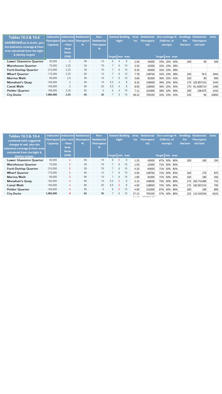
- The floor area ratio and dwelling units/ha figures for the City docks are far too low for the indicated building heights as it yields an anomalously low site coverage figure and therefore should raised to a more appropriate level
- We support the clear streets hierarchy and use of pedestrian/cycle streets in the City docks but oppose the routeing of through motor traffic over the new bridge and along Monahan Rd.
- We support the vision for mobility hubs in the city docks but feel that the proposed provision of 300 car parking spaces at each is an order of magnitude too many spaces and parking should be limited to circa 30 car sharing space at each mobility hub and drop-off loading zones in the rest of the city docks.
- The proposed total parking maximum in the city docklands is an order of magnitude to large at 10,280 it greater then the proposed total number of dwellings, this needs to be radically reduced.
- Cork airport business park is not a suitable location for office developments as it is in an isolated location which relies on a single congested public transport link and is inaccessible by walking or cycling
Overview
If time and resources were not an issue we would have liked to have given as much time and gone into as much detail on the city centre, City docks and Tivoli area plans as we have for each other chapter in this plan. We would have also like to have had written a substantial submission on each of the other area plans in this chapter.
However, as our time and resources are finite, we have only been able to produce the most cursory and incomplete submission on the detail of this chapter and hope to comment more fully on the area plans in due course.
Section 2. City Docks
Overview
The general vision and intent of the plan, such as the clear streets hierarchy and use of pedestrian/cycle streets is to be commended and has our support as it is in line with the commitments 2 compact growth and a 15-minute City. However, there are a number of details which are in conflict with these objectives. Including that the total number of Dwellings proposed is far below what can be achieved on the site at the intensity of development which is outlined in the plan, the amount of car parking to be provided vastly exceeds the requirements of the site even assuming no reduction in-car use by residents or workers in the new development compared to the present city centre situation and the routing of arterial motor traffic through the site is of concern.
We Strongly support the following objectives unchanged as they are in the current draft
Objective 10.17
Objective 10.18
Objective 10.19
Objective 10.20
Objective 10.23
Objective 10.24
Objective 10.25
Objective 10.27
Objective 10.28
Objective 10.29
Objective 10.30
Objective 10.32
Objective 10.33
Objective 10.34
Objective 10.35
Objective 10.36
Objective 10.37
Objective 10.26
We support the following objectives and suggest the following modification/additions to strengthen their effectiveness in achieving the Strategic objectives laid out at the beginning of Chapter 2
Objective 10.26
Specific Land Use Objectives
Existing text
Objective 10.26
Specific Land Use Objectives
It is an objective of Cork City Council to ensure that:
• The western neighbourhood / local centre is centred upon the western City Docks LRT stop.
• Live ground floor uses are provided in appropriate locations and restricted in all other areas to ensure a good quality of residential amenity in the new residential neighbourhood.
Suggested Strengthening
Objective 10.26
Specific Land Use Objectives
It is an objective of Cork City Council to ensure that:
• The western neighbourhood / local centre is centred upon the western City Docks LRT stop.
• Live ground floor uses are encouraged with appropriate uses confined to appropriate locations and restricted to 9 to 9 uses in all other areas to ensure a good quality of residential amenity in the new residential neighbourhood.
Objective 10.31
Draft Cork City Docks Area-Based Transport Assessment (ABTA)
Existing text
Objective 10.31
Draft Cork City Docks Area-Based Transport Assessment (ABTA)
To implement the Draft Cork City Docks ABTA and its key recommendations, including:
• Achieving a 75:25 modal split in favour of sustainable transport modes.
• The delivery of the City Docks Transport Network and a clear street hierarchy that confines vehicular access to the City Docks within traffic cells in order to optimise the placemaking and public realm potential of the City Docks.
• High quality walking / cycling streets and strategic routes along the quays, including improvements to the pedestrian / cycle realm at Albert Quay / Eamon de Valera Bridge (as illustrated in Volume 2: Mapped Objectives).
• Transit orientated development, including the phased delivery of improvements to public transport from bus services, high quality bus services and the LRT.
• City Docks Bridge delivery.
• The provision of new pedestrian / cycle streets between Monahan’s Road and Blackrock Road.
• Demand Management measures including maximum car parking standards.
• Preparation of a Mobility Hub Feasibility Study during the lifetime of this Plan.
Suggested Strengthening
Objective 10.31
Draft Cork City Docks Area-Based Transport Assessment (ABTA)
To implement the Draft Cork City Docks ABTA and its key recommendations, including:
• Achieving a 90:10 or greater modal split in favour of sustainable transport modes.
• The delivery of the City Docks Transport Network and a clear street hierarchy that confines vehicular access to the City Docks within traffic cells in order to optimise the placemaking and public realm potential of the City Docks.
• High quality walking / cycling streets and strategic routes along the quays, including improvements to the pedestrian / cycle realm at Albert Quay / Eamon de Valera Bridge (as illustrated in Volume 2: Mapped Objectives).
• Transit orientated development, including the phased delivery of improvements to public transport from bus services, high quality bus services and the LRT.
• City Docks Bridge delivery as a dedicated active and public transport link.
• The provision of new pedestrian / cycle streets between Monahan’s Road and Blackrock Road.
• Demand Management measures including maximum car parking standards.
• Preparation of a Mobility Hub Feasibility Study during the lifetime of this Plan.
We believe that the following objectives need modification to avoid conflict with the Strategic objectives laid out at the beginning of Chapter 2 and we cannot support without the following modifications.
Possible serious conflict between the figures in tables 10.3 and 10.4 the vision outlined in the other objectives and the figures in objective 10.32
We support the indicative height laid out in tables 10.3 and table 10.4, we strongly support the maximum hights in conjunction with the separate provision for tall builds, while we would be open to increasing the minimum guidance to 5 stories in all areas.
Given these indicative Heights and the commitment in objective 10.32 to a 15% minimum public open space/public realm space the floor area ratios in 10.3 to do not appear correct. Combining the indicative Heights and the FAR figures from tables 10.3 and 10.4 suggests a site coverage percentage in the region of 33% an extremely low figure in an urban context usually accosated to the use of significant space by parking.
An urban development this we would expect site area to be broken down into to public realm, access, car parking, technical/logistical spaces and the area covered by buildings. Given that access in the majority of cases is from pedestrian/cycle streets and we are assuming that no surface parking is allowed in this area that yields an almost 85% site coverage available for buildings plus technical/logistical spaces.
The difference between this 85% figure and the 33% in figure implied from the FAR figures in table 10.3 is over 50% of the total site area! This is far too large an area to be accounted for by access or logistic/technical space. Is this space to be dedicated to car parking or are the figures in error?
We would strongly suggest that the floor area ratios be modified to reflect indicative site coverage percentages of circa 70-75% building coverage and circa 25% public open space/public realm/access space with no less than 15% public open space and no more than 5% of site area allowed for technical logistics or parking use. Any reduction in built site coverage should be used as extra public open space.
Mobility hubs
We strongly support the provision of the proposed mobility hubs in the area plan.
However, we are extremely concerned at the proposal that the mobility hubs consist of circa 300 parking spaces. A mobility Hub should be multimodal, allowing access to public transport and micro mobility such as the public bike scheme, parcel pick up and drop off as well as an interchange with motorised transport such as van to cargo bike for last mile delivery in more suburban locations the provision of a limited number of private car parking spaces in such mobility hubs is appropriate. Given the central City location of the city docks we would propose that any car parking provided should be wholly or at least majority car share rather than private car parking spaces.
The provision of 300 car parking spaces at a single hub is grossly disproportionate and would transform the mobility hub into a park and ride at best and simple a car park at worst while the other features are eclipsed and overshadowed rather than a multimodal mobility hub. The number of car parking spaces in each mobility hub should be limited to no more than 25/30. Ideally the space dedicated to car parking including access for the car parking spaces should not exceed 50% of the area of the mobility hub.
Section 3. Tivoli
If time and resources
Section 4. Cork Airport
If time and resources
-