Built Heritage Objectives Part 1: Architectural Conservation Areas
Existing Architectural Conservation Areas |
| Albert Quay |
| Albert Road |
| Ballinlough Road (Annville / Ardeevin group) |
| Bandon Road 38-43 and Lough Road 58-60 |
| Barrett’s Buildings, off Blarney Street |
| Bethesda Row, Old Blackrock Road |
| Bishopstown Park |
| Blackpool |
| Castleview Terrace 1-11, Lower Glanmire Road |
| Coburg Street and Saint Patrick’s Hill |
| Corporation Buildings, Saint Paul’s Avenue |
| Douglas Road-Northwest |
| Former Ford Factory (Marina Commercial Park) |
| Friar Street |
| Grattan Hill, Lincoln Place, Hackett’s Terrace and Mahony’s Avenue |
| Greenmount |
| Lower Glanmire Road |
| The Mardyke |
| Marie Place 1-12, Windmill Road |
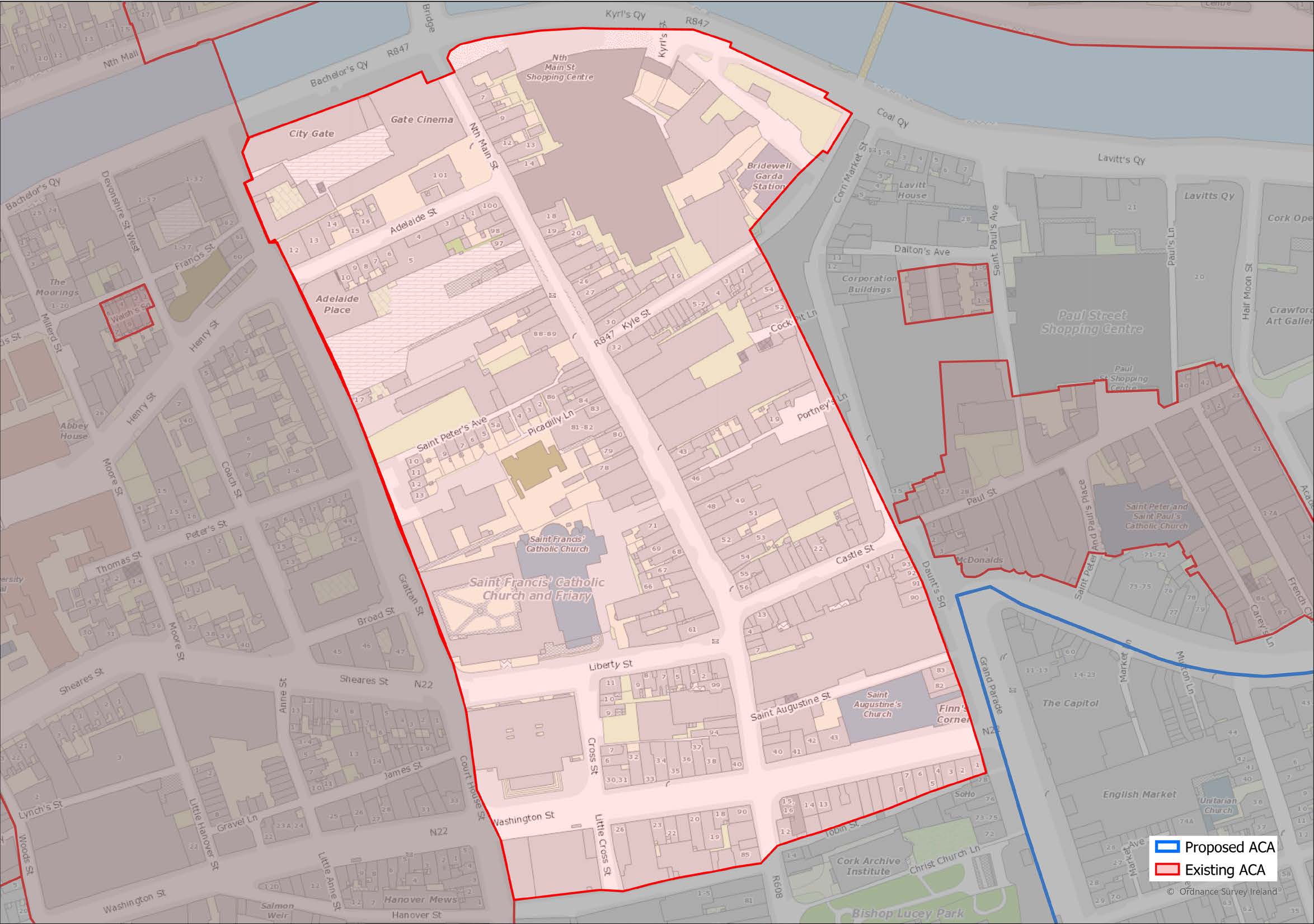
| North Main Street |
| North Mall / The Marsh |
| Paul Street |
| Railway Cottages 1-13, Anglesea Street |
| Rockboro Road 18-20 |
| Shandon |
| South Parish |
| Vandeville 1-4, Ballinlough Road |
| Victoria Road |
| Walsh’s Square, Devonshire Street West |
ACA
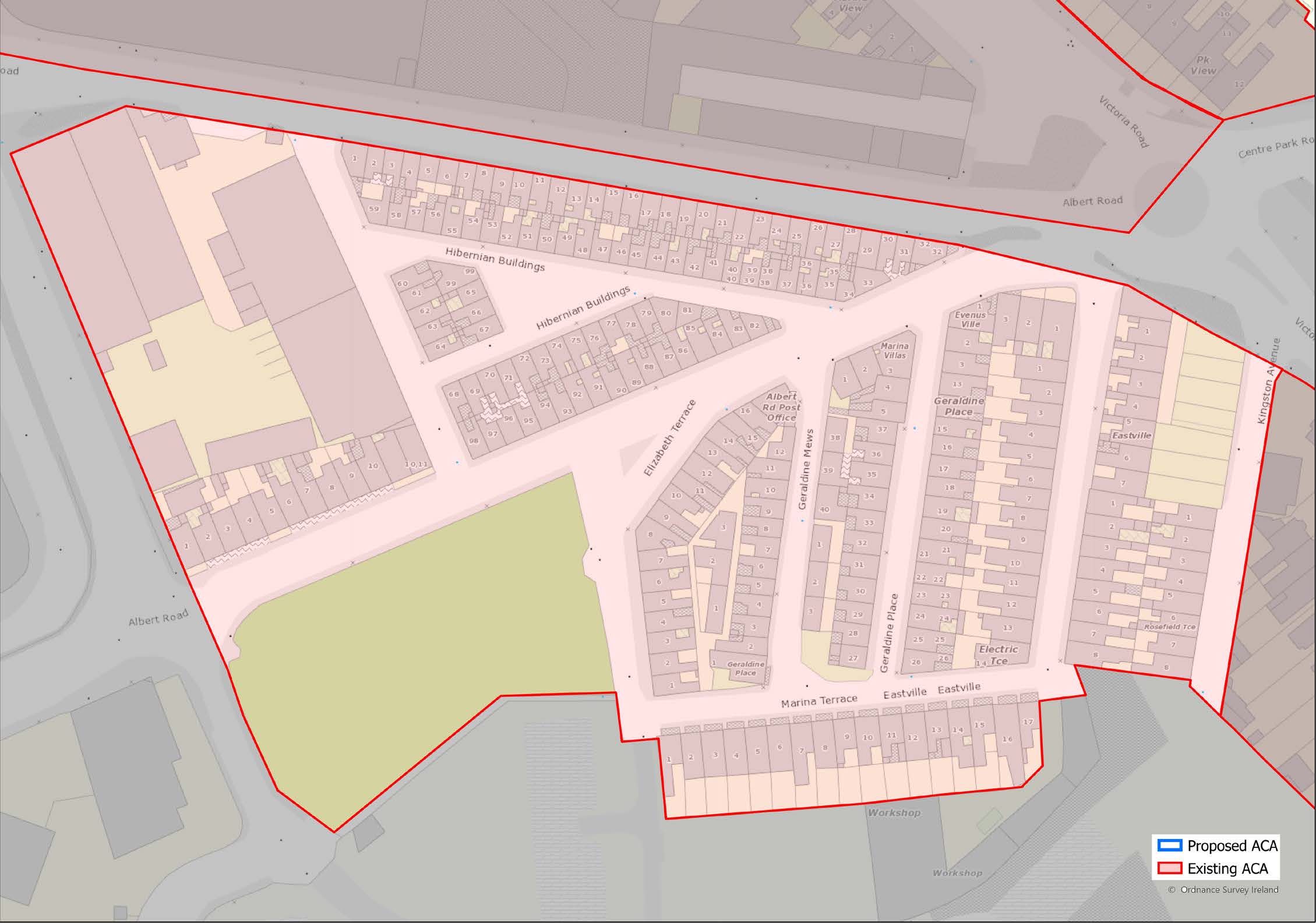
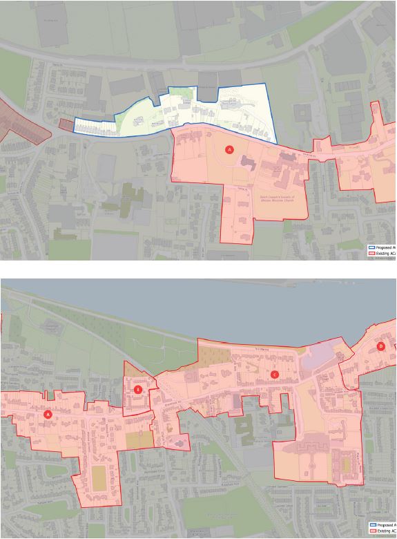
Albert Quay, Albert Road and Victoria Road

(Click on Map for High Resolution Image)

1.08
The area is bounded by Albert Quay, Victoria Road, Albert Road and Albert Street. It is contiguous with the Albert Road ACA to the south and the Park View ACA to the east.
1.09
The area is located within the South Docks immediately to the east of the city centre. It contains extensive areas of both undeveloped lands and under-used low-rise buildings, mainly single storey, and is likely to be redeveloped during the life of the present Development Plan. It is part of an area identified in “Cork City Harbour – Unlocking Cork Docklands” and the City Centre Strategy as an appropriate location for large floor plate offices, which are of strategic importance for Cork. This strategic need will be taken into account in assessing development proposals. The aim should not be to retain all existing buildings and features but to encourage appropriate development of vacant land and under-used buildings by retaining the most significant elements of heritage interest as an integral part of the evolving character of the area.

1.10
In addition to the attractive painted plastered classical buildings of the former CBP Railway, the area contains a mix of large scale former industrial and warehouse buildings with both cut- and rubble limestone facades and smaller-scale painted, plastered public houses, office buildings and blocks of brick and painted, plastered houses. Where buildings retain original elevational features, they have timber sliding sash windows, roofs of natural stone slate and cast-iron rainwater goods.

1.11
The area is located within the South Docks immediately to the east of the city centre; it contains extensive areas of both undeveloped land and under-used low-rise buildings, many single-storeys, and is likely to be developed during the life of the present Development Plan. The aim should not be to retain all existing buildings and features but to encourage appropriate development of vacant land and underused buildings by retaining the most significant elements of heritage interest as an integral part of the evolving character of the area.
ACA
Albert Road
1.12
In the late 19th century, a considerable population of Lithuanian Jews settled in the Albert Road area that subsequently became known as ‘Jewtown’. The area consists of a collection of six terraces comprising a total of 99 two-bay single-storey with attic houses called Hibernian Buildings. The Jewish heritage sets it apart from anywhere else in the city, whilst the modest artisan dwellings are an excellent reminder of the city’s industrial heritage.
(Click on Map for High Resolution Image)
ACA
Ballinlough Road
(Annville / Ardeevin
Group)
1.13

(Click on Map for High Resolution Image)
ACA
Bandon Road 38-43
& Lough Road 58-60
1.14
A prominent corner group of one-and-a-half storey artisan housing, built c.1889, fronting onto Bandon Road and Lough Road, with a two-storey corner-sited three-bay two-storey purpose-built commercial premises and house linking the two terraces. Particularly distinctive due to the quality of materials used in the construction, such as red-brick, natural slate & limestone.

(Click on Map for High Resolution Image)
ACA
Barrett’s Buildings,
Off Blarney Street
1.15
Consists of 6 parallel terraces of two-storey, two-bay artisan houses built in 1906 by Cork Corporation. The houses retain many of their original features and their uniformity gives the area a distinctive character.

(Click on Map for High Resolution Image)
ACA
Bethesda Row,
Old Blackrock Road
1.16
Little-altered terrace of 4 three-bay, single-storey over basement houses, built in1896 and located on the north side of Old Blackrock Road. This row is significant as part of a group retaining timber sash windows, hood mouldings to the front elevation of all four and with consistent scale and roofline.

(Click on Map for High Resolution Image)
ACA
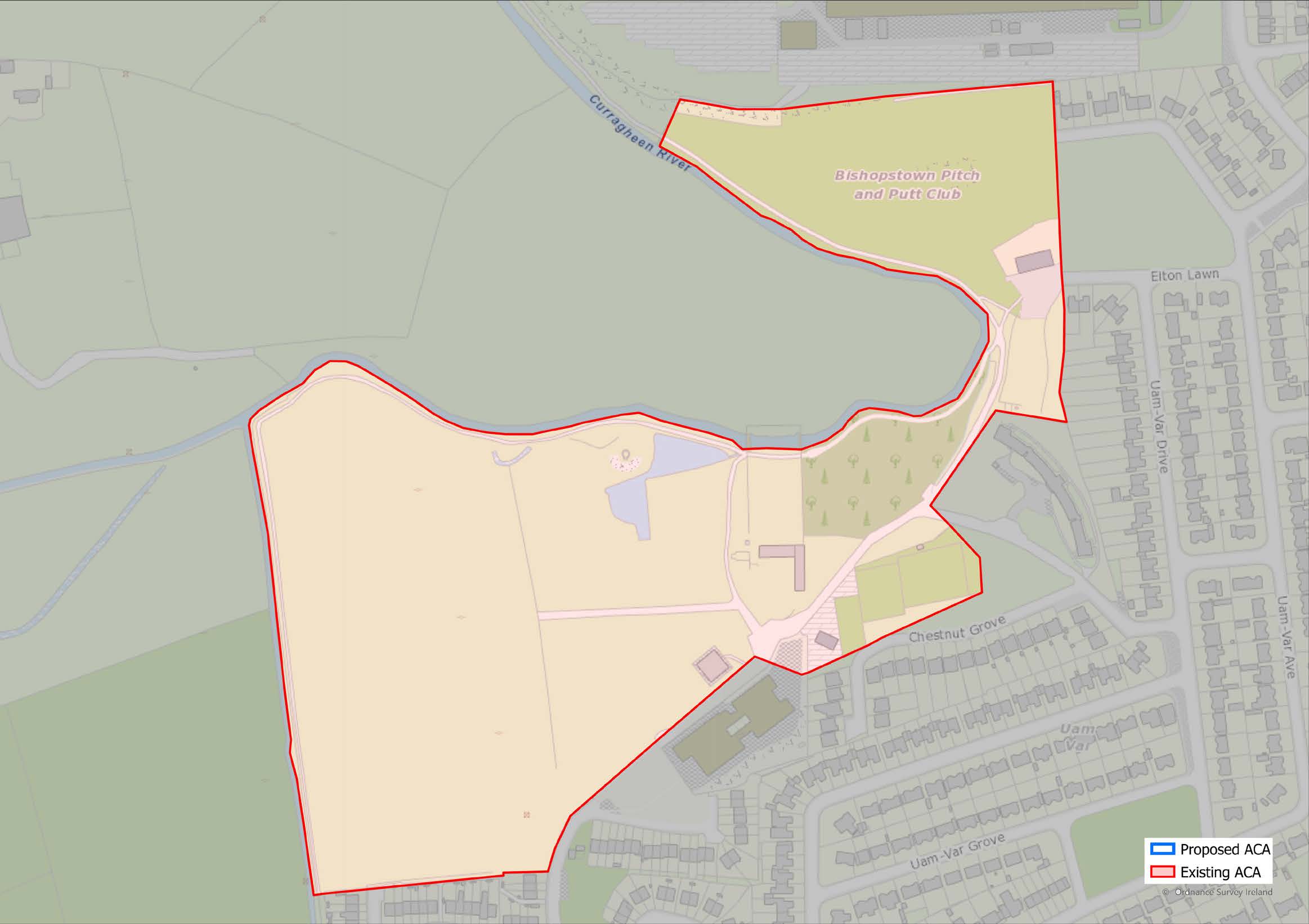
Bishopstown Park
(Click on Map for High Resolution Image)

1.17
Bishopstown Park, known as ‘Murphy’s Farm’, locally is located on the western fringe of Cork City. The Curragheen River forms a natural boundary of Bishopstown Park ACA, while the administrative boundary between Cork City and Cork County is also a defining factor in its irregular form. It is bound to the east by the Riverside Pitch and Putt course. This northern boundary is located adjacent to CIT, while to the south the ACA is bound by Bishopstown Tennis Club and Scoil Naomh Therésé. The walkway which follows the natural pattern of the Curragheen River defines the western boundary.

1.18
The area within the boundary maintains the character of a traditional demesne landscape with its combination of undulating terrain, flat open spaces and more formal designed areas with orthogonal stands of trees and shrubs. Consistent with the primary usage of the land, the area is recreational in character. This relatively compact ACA comprises of three distinct visual sections:
1.19
The Pitch and Putt course is separated from the rest of the ACA by a thin band of land created by the boundary with Elton Lawn and the arc of the Curragheen River. Characterised by a rolling topography, the land flows naturally in a series of crests and troughs before falling gently to meet the walkway and the edge of the river. It also houses the site of the former 18th century limestone quarry which, although now hidden by overgrown vegetation, still maintains a prominent position at the centre of the course.
1.20
The area central to the ACA is that of the walled garden, buildings and courtyard as well as its immediate surroundings. This sub-area has a traditional demesne feel, with more formal spaces contained by walls, planned ponds, vegetation and contouring. The main approach to the park via the road maintains the same character as it did when the manor house was first built in the 18th century. Framed by trees, the view of the community centre is gradually revealed along the gently curving avenue. Water bodies such as the Curragheen River, the canal and the L-shaped pond add visual and aural interest.
1.21
The playing fields to the west are uniquely different in character with its open flat terrain bounded by elongated contours and orthogonal lines of trees. When approached from the east, the combination of trees with the designed soil mounds, frame the view and through visual contrast, further enhance the character of this sub-area.

1.22
There is a mixture of buildings on site, mostly centred on the courtyard. These include the chapel and the privy, both of which are 18th century structures built of random rubble sandstone with limestone details, with direct associations with the original mansion house. Despite the effects of vandalism and the invasion of vegetation, the chapel retains many of its architectural details including limestone sills and quoins, cut-stone walls and pediment containing green and red sandstone as well as some slate. The late 20th century farmhouse, now home to the Scout Hall and Community Centre, utilises the surviving cut limestone plinth-moulding which served as a retaining wall as well as the base of the original mansion house. The eastern elevation contains the limestone door surround of the original house and is the last remaining remnant of the original mansion house for which the park was created, with its prominent key stone and consoles supporting projecting cornice. It is a visual representation of the finely detailed masonry and craftsmanship associated with 18th century mansion houses.
1.23
The Shell House, which sits on an outcrop of rock over-looking the river and ornamental ponds, takes advantage of natural and artificial vistas. Having also felt the effects of vandalism and weathering, it retains many of its details such as the fireplace on its northern wall, glassy slag plinth, crenelated walls and beehive porch. The 18th century limekiln which is now hidden from view due to overgrowth of vegetation sits into the side of a hill and uses the topography to its advantage in order to minimise the amount of brickwork or masonry in its construction.
1.24
Although many boundaries on site are created naturally through the use of trees and shrubbery, there are a number of manmade features that create more formal spaces within the park. The 18th century Walled Garden is unique as its clearly defined boundary of cut limestone walls and footbridges, frames the view towards the river.

1.25
Currently, Bishopstown Park is an underutilised public amenity with immense recreational potential. It has suffered significant damage in recent year from vandalism and overgrowth of vegetation, especially with regard to the shell house, chapel and limekiln. Sections of the park such as the courtyard and its surrounding community buildings would benefit from an improvement in aesthetic quality to increase the amenity for local residents and recreational users. Improvement to the public realm such as the addition of benches and litter bins would do much to enhance the environmental quality and to improve the parks character.
ACA
Blackpool
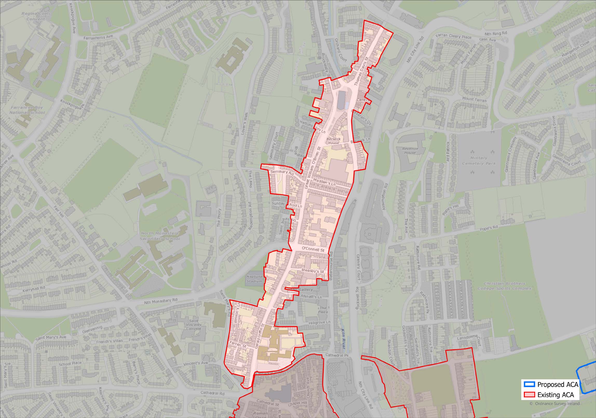
(Click on Map for High Resolution Image)

1.26
The area is centred on the main thoroughfare running south-north from Old Chapel Lane and Cathedral Street to Thomas Davis Street and the Link Road. It is bounded to the east by the western boundary of Watercourse Road and to the west by the rear of properties fronting onto the area’s central spine of Gerald Griffin Street, Great William O’Brien Street and Thomas Davis Street.
1.27
It also takes in the terraces and narrow laneways of the area’s south-western section radiating out from Farren Street, the buildings fronting onto Seminary Road, Arthur Villas and Foley’s Row to the east of Watercourse Road, and the buildings to the east of Thomas Davis Street.

1.28
The character of the area, of architectural, archaeological, historical, and social significance, varies as you move northwards away from the city centre. It is made up of three sections, firstly: Gerald Griffin Street to the south, secondly: the central section of Great William O’Brien Street and thirdly: Blackpool Village centre, situated in the area focused around the church in the north. Collectively, the streets formed the principalroute from the city leading north for hundreds of years, the urban form of which has remained largely unchanged. The area was the industrial centre of the city in the 19th century, evident by the high concentration of tanneries, distilleries, mills, maltings and breweries that once occupied it. This has resulted in a rich legacy of industrial archaeology within the area.
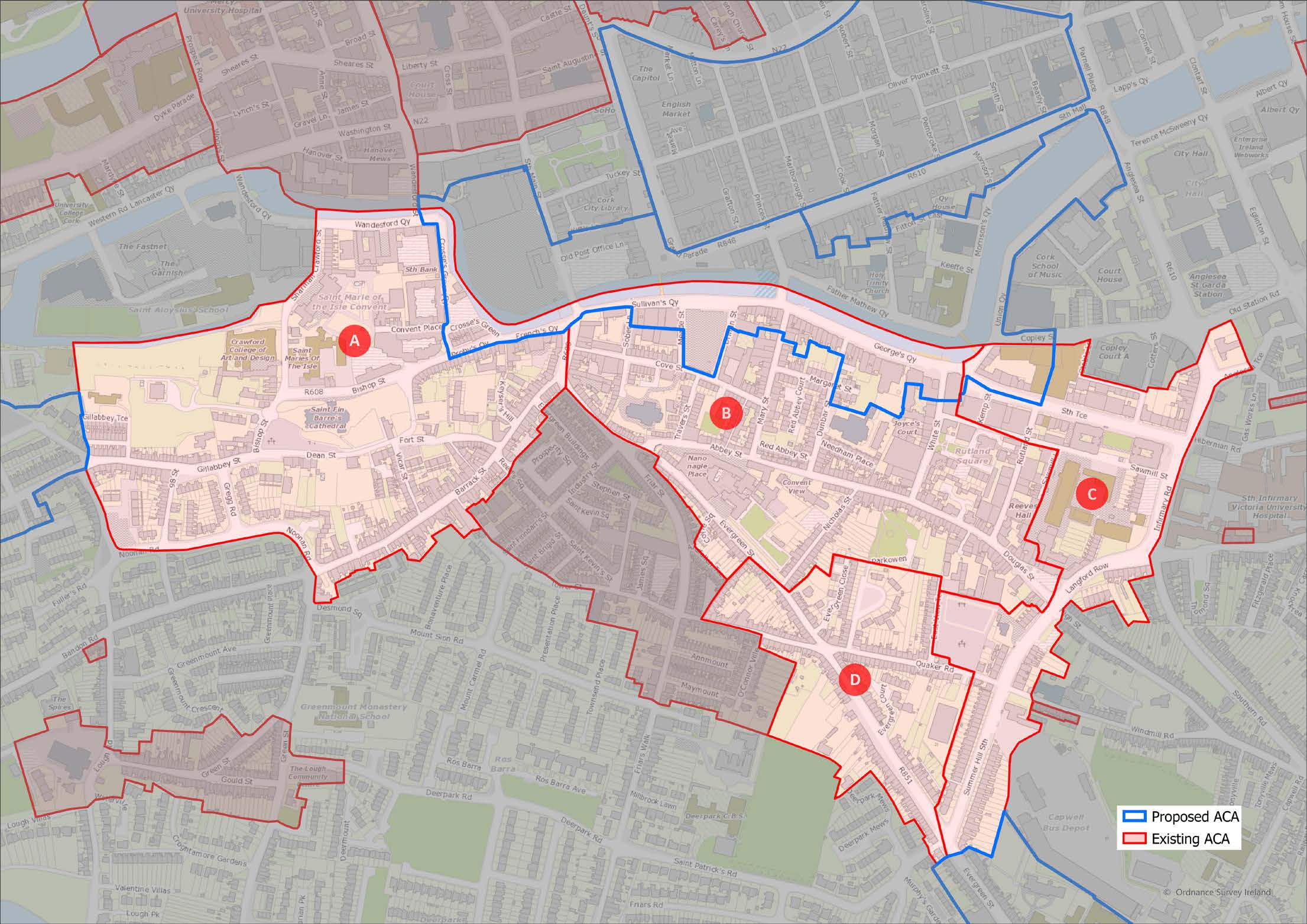
1.29
The first, southern, sub-area has a mix of uses but is mainly residential in character, with two and three-storey, mainly two-bay dwellings lining Gerald Griffin Street. Commercial and institutional buildings are largely located at the southern end of the area. The North Presentation Convent, associated with the area since the late 18th century, dominates the south-eastern section of the sub area, while there is a high-density residential area to the south-west located around Farren Street. These are laneways of one and two-storey houses, typical of the historic urban patterns prevalent in the area in the 18th and 19th centuries.
1.30
The second middle sub-area of the area along Great William O’Brien Street is largely residential in character consisting mainly of 19th century housing. There are a number of examples of 18th century buildings, notably at No.54, possibly the earliest building in the area, notable for its simple vernacular quality. The first example of modern social housing in Cork is found on the eastern side of the road in the form of Madden’s Buildings, which were built by Cork Corporation in 1886. These are an important part of Cork’s social heritage.
1.31
The third sub-area is centred on Blackpool Village, the area surrounding the church, the site of the original marketplace. This area has retained its historic street pattern resembling an elongated ‘X’. This unusual layout was dictated by the waterways that subsequently influenced the layout of the streets. Buildings have generally commercial and/or residential uses, are two and three-storeys in height, of two or three-bays, and largely date from the 19th and 20th centuries. Mature trees line the western side of the road leading to the village centre from the south. The attractive pair of 18th century buildings at Nos. 96 and 97 (Dennehy’s Fish Shop and adjacent building) terminate the northern vista from Great William O’Brien Street and provide an attractive bookend to the street.

1.32
The area’s building stock ranges from the 18th to 20th century but is mainly characterised by the 19th century residential two and three-storey buildings that line the principal thoroughfare. Several examples of 18th century buildings, are also evident, identified by their steeply pitched roofs and narrower openings on the upper floors. As is traditional in the area, buildings are generally constructed of rubble-stone or brick, usually rendered and painted. Smaller one and two-storey dwellings are located in the laneways off the main street, indicative of the type of building and plot layout prevalent in the 18th and 19th centuries.
1.33
The Church of the Annunciation dominates the streetscape of the village centre and is significant as the work of the sculptor Seamus Murphy who served his apprenticeship in a Blackpool stone yard. There are a number of traditional timber shopfronts in the area that have been retained even in cases where the buildings no longer serve as commercial premises. Where buildings have retained their original features and finishes, they have painted plastered facades, roofs of natural stone slate, castiron rainwater goods, and painted timber doors and sash windows.

1.34
The area around Blackpool Village centre and the northern part of Great William O’Brien Street benefitted greatly from the Blackpool Renewal Scheme which improved the aesthetic quality of the streetscape by introducing features such as mature trees, attractive iron lamp standards, and simple, well-designed paving and soft landscaping. Other sections of the street would benefit from a similar scheme both to enhance their environmental quality and to emphasise the continuity of the character of the historic route. The retention of the traditional timber shopfronts in the southern part of the area should be encouraged as they provide a social narrative on the street’s former commercial viability at one time and are in themselves often of good quality.
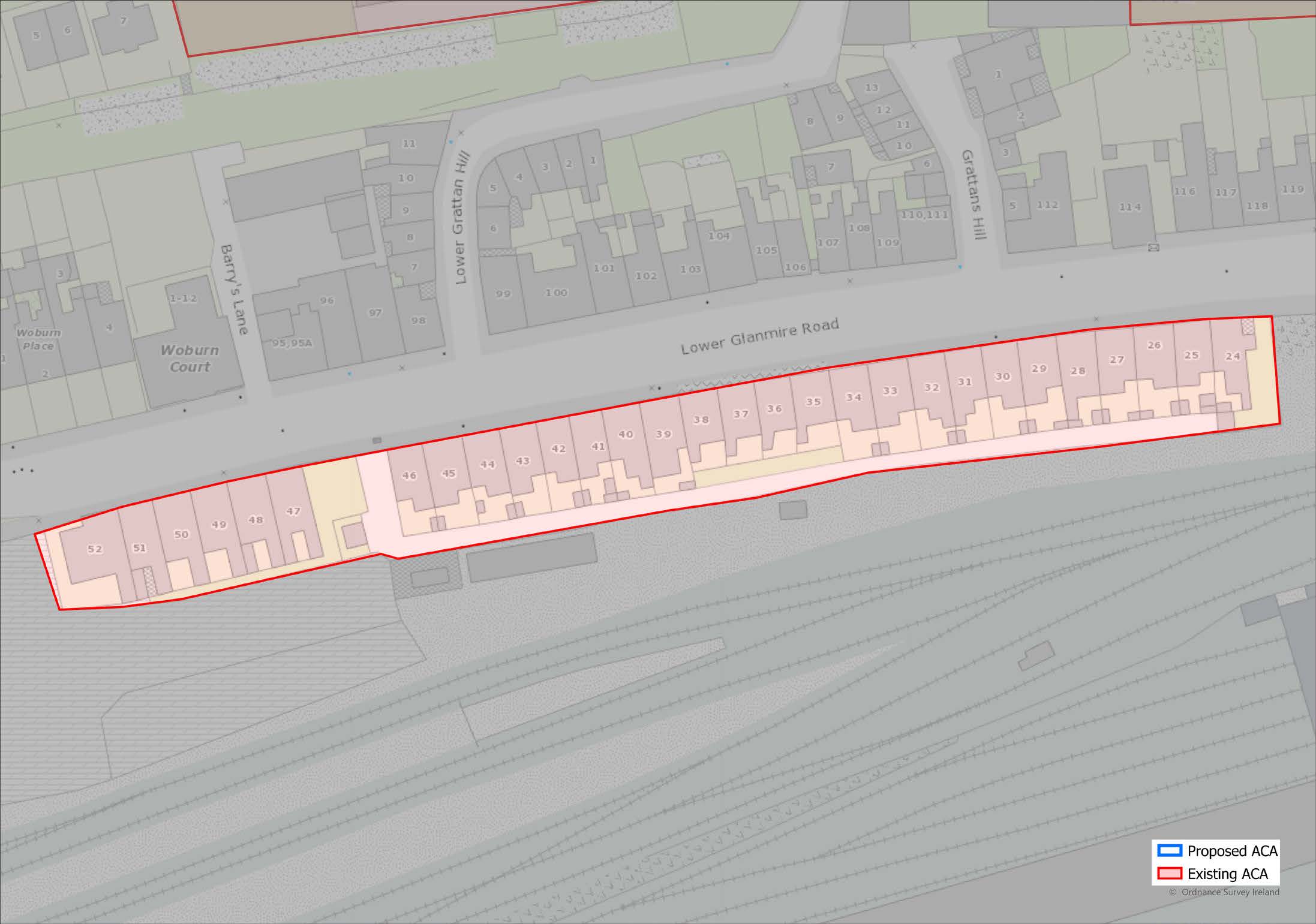
ACA
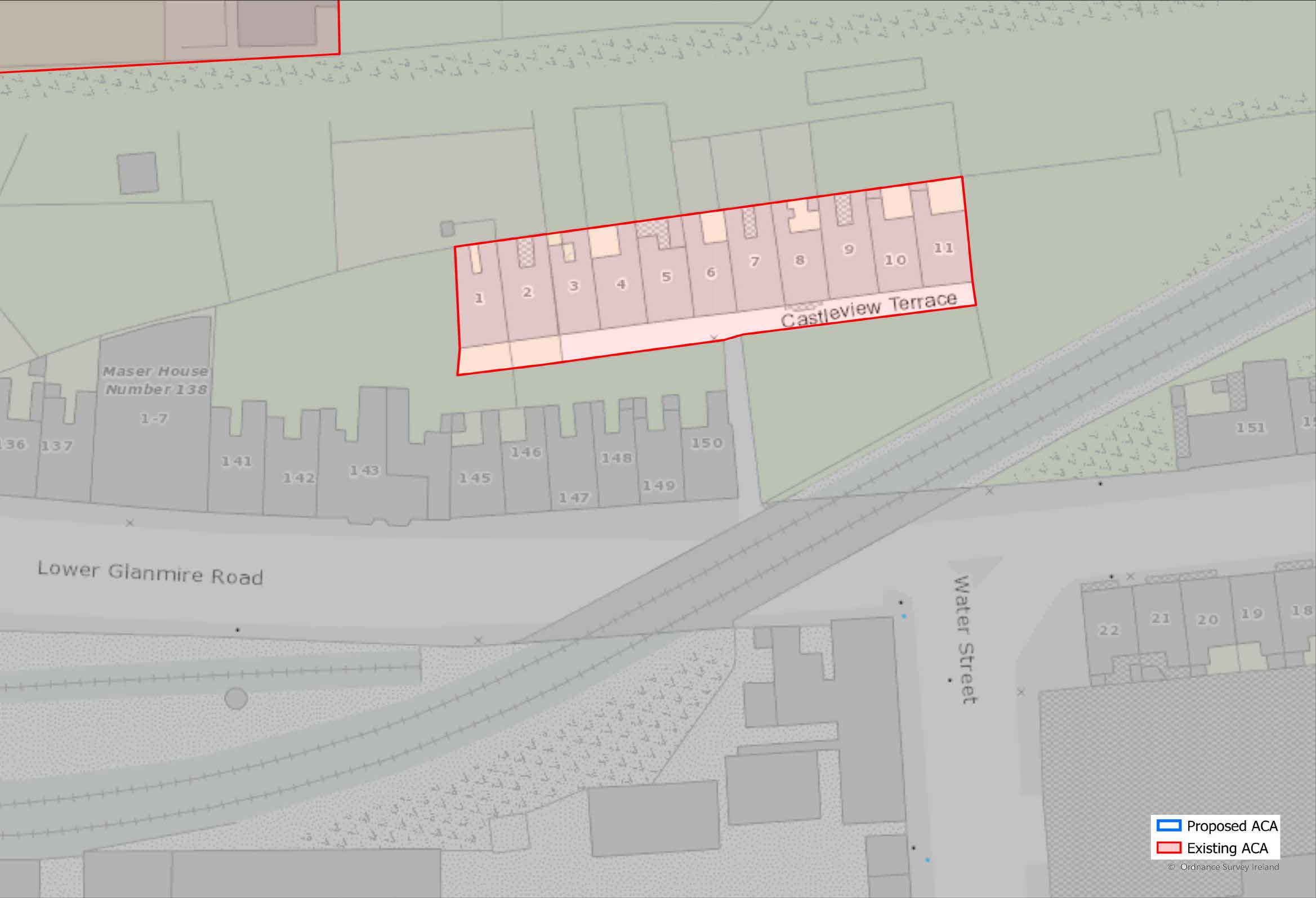
Castleview Terrace
1-11, Lower Glanmire
Road
1.35
Castleview Terrace consists of eleven red-brick two-bay, two-storey houses, built c. 1868, on a secluded height above the Lower Glanmire Road with a view of Blackrock Castle. It is one of the earliest examples of this type of red-brick terraced housing in Cork.
(Click on Map for High Resolution Image)
ACA
Coburg Street and Saint Patrick’s Hill
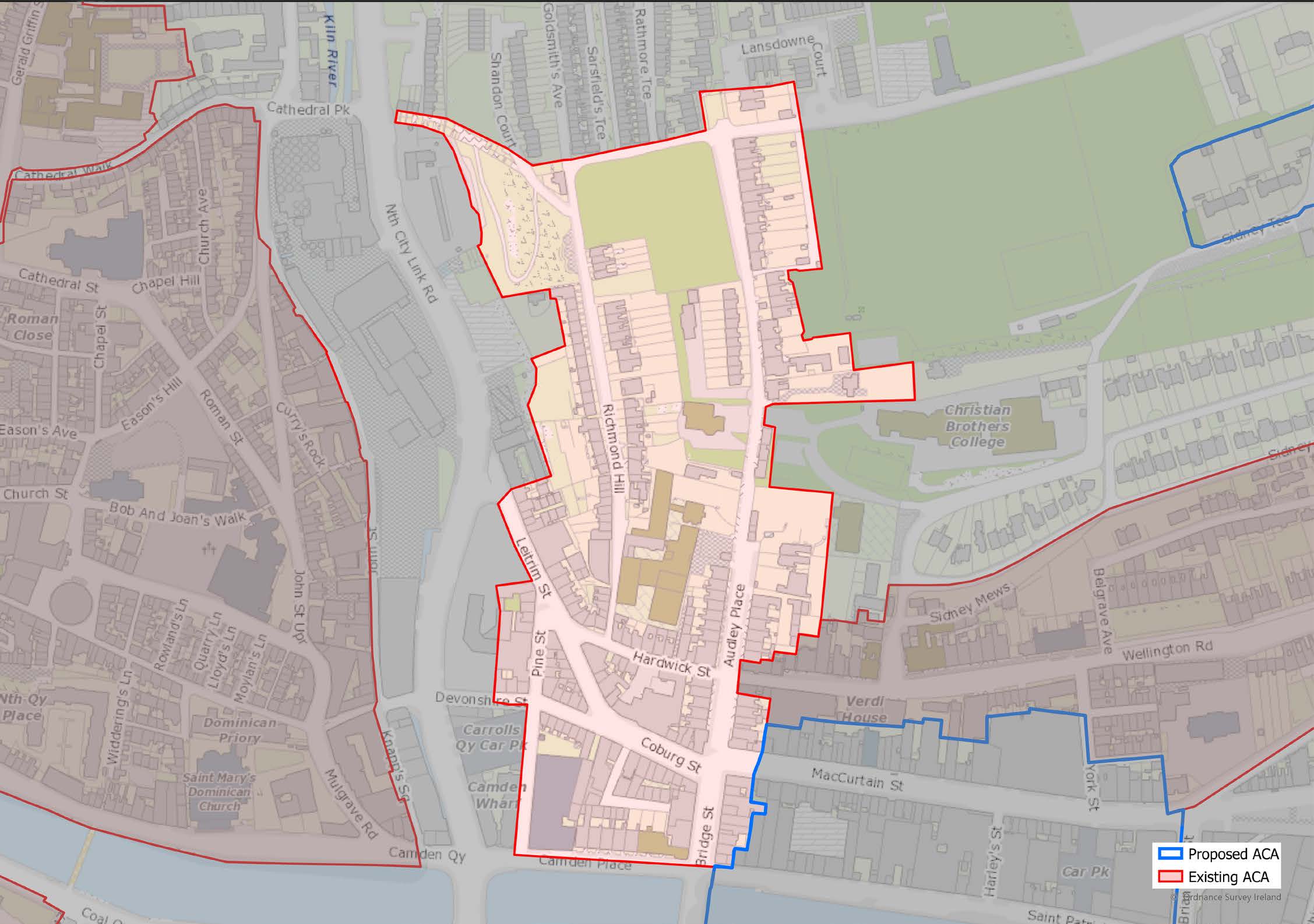
(Click on Map for High Resolution Image)

1.36
The Coburg Street and Saint Patrick’s Hill Architectural Conservation Area is located north of the North Channel of the River Lee directly opposite the commercial core of the city centre, on rising south- and west-facing ground. It is mixeduse in terms of character and combines retail and commercial uses with a residential function. The area is located outside the walled medieval city of Cork, situated a short distance to the southwest on the north and south islands of the River Lee. It developed from the mid-18th century when the land bounded by Carroll’s Quay, Leitrim Street, Coburg Street, and the River Lee was reclaimed and subsequently laid out with streets and buildings and commercial quaysides.

1.37
The overlapping street layout given by the intersection of the steeply sloping north-south streets, Richmond Hill and St. Patrick’s Hill with McCurtain St., the intersection of Coburg St. and McCurtain St. and the quays running east-west provides a strong urban framework to contain the varied styles of architecture constructed as the area evolved from the mid-18th century to the present.
1.38
Buildings on the higher levels of the hillside such as the detached villas at the top of St. Patrick’s Hill, or the terraces of Audley Place, have a tendency to orientate themselves towards the west or southwest taking advantage of the views over the Kiln river valley towards Shandon and the hillsides beyond. Even where the front elevations face eastwards, many houses, e.g., on the west side of Richmond Hill, make use of the falling ground to take advantage of these views. The west facing upper slopes of the hillside provide an important historical amenity area and open spaces such as Lady’s Well (containing a post medieval holy well) and Bell’s Field, from which there are panoramic views of the city.
1.39
The area is of archaeological significance because it is partially situated within the Zone of Archaeological Potential (ZAP) for Cork City (CO074-122). A holy well (CO074-062), situated at Lady’s Well, is also listed on the Record of Monuments and Places. The area is of historical and architectural significance because of its street layout and for its stock of buildings from the 18th to 20th centuries which provide evidence of its evolving urban character over three centuries.
1.40
There are a number of buildings which are included on the Record of Protected Structures (RPS) and also identified on the National Inventory of Architectural Heritage (NIAH) as being of regional significance. These include terraced Georgian buildings on Camden Place, the ashlar limestone quay walls at Camden Quay, terraced housing on Devonshire Street, housing on Saint Patrick’s Hill and Richmond Hill, the Ursuline Convent and St. Angela’s College.

1.41
Traditionally, the area’s buildings, whether domestic, commercial, or industrial, and dating from the early 18th to the early 20th centuries, are generally constructed of painted plastered rubble-stone or brick walls. Where they retain original finishes and features, they have roofs of natural stone slate, robust cast-metal rainwater gutters and downpipes and painted timber doors and windows, and many good examples of iron railings and gates. Where historic street furniture or paving survives, such as limestone steps or kerbing, iron handrails etc. it is important for the character of the area that these are retained.

1.42
The area has a wide range of house types and local facilities including shops, pubs, schools, and recreation spaces. However, the area is under increasing pressure from traffic and has a poorquality public realm which detracts from its amenity for residents and businesses. It is important that this be improved to encourage greater use of the existing building stock in a way that makes best use of its potential. There are also some vacant and under-utilised plots in the area, with scope for development to support and reinforce the strong existing character of the area.
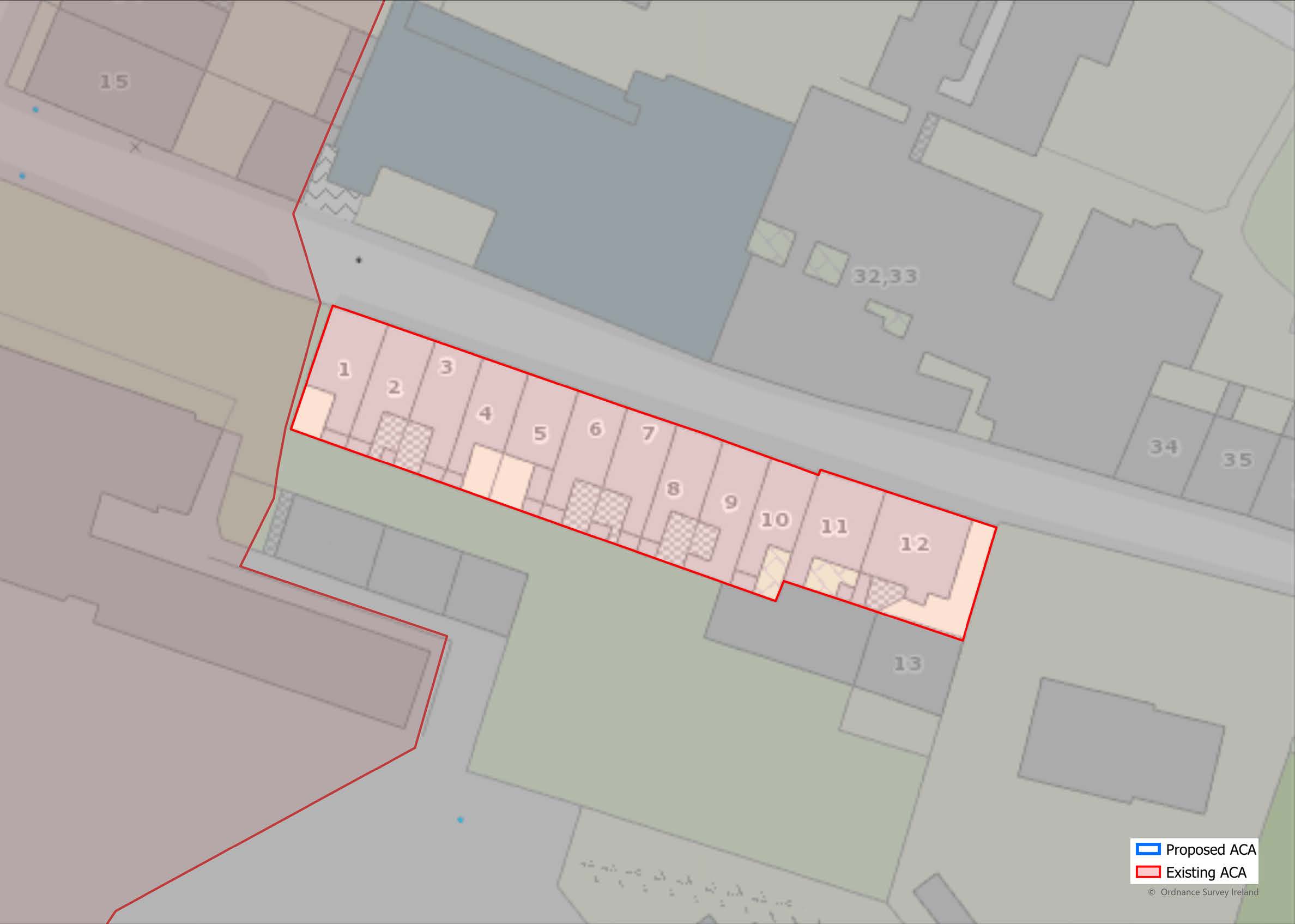
ACA
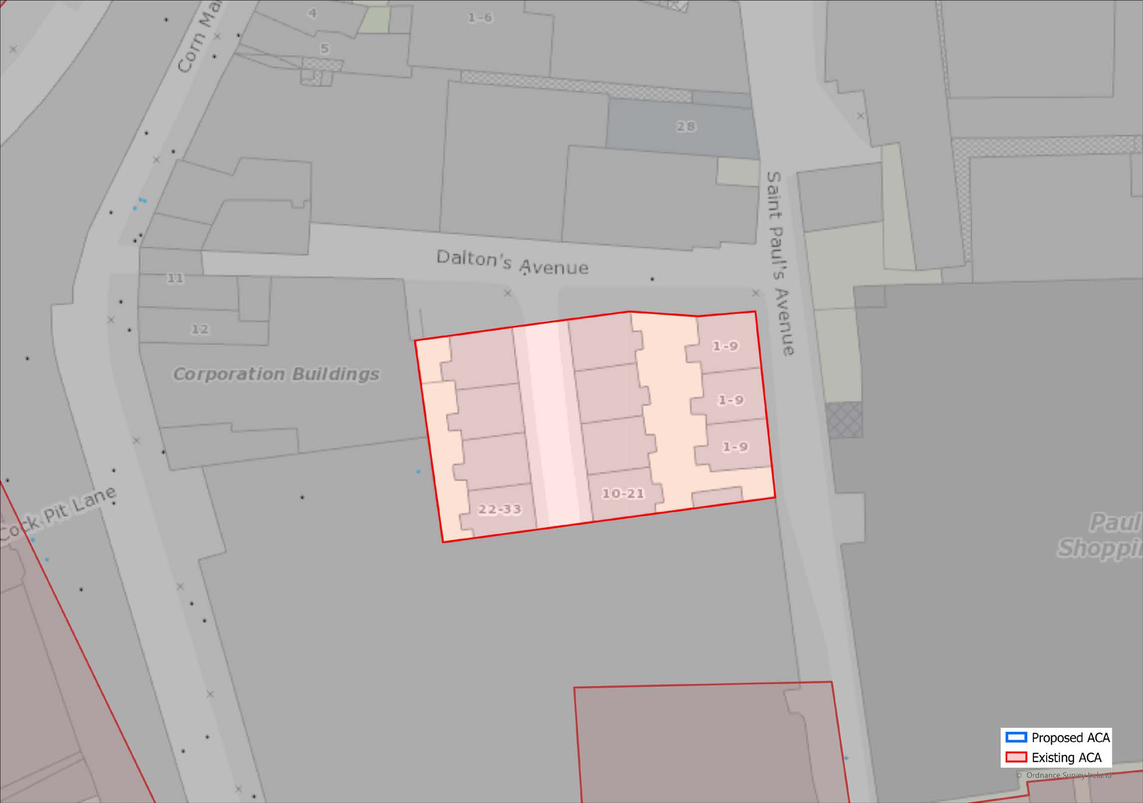
Corporation Buildings,
St. Paul’s Avenue
1.43
A residential enclave of 11 three-storey, four-bay buildings, organised into three terraces. They were built in 1900 as ‘Corporation of Cork’ labourers dwellings. These buildings are a good example of the quality of architectural design employed by the local authority at the beginning of the 20th century.
(Click on Map for High Resolution Image)
ACA
Douglas Road -
Northwest
1.44
This ACA is comprised of 6 terraces of painted rendered houses lining the southern side of the northwest part of Douglas road namely Beechwood Place, Eldred Terrace, Fernwood, Belmont Place, Laurel Wood and Pinewood. They date from the late 19th and early 20th centuries and are an attractive group example of middle-class suburban development of the time.

(Click on Map for High Resolution Image)
ACA
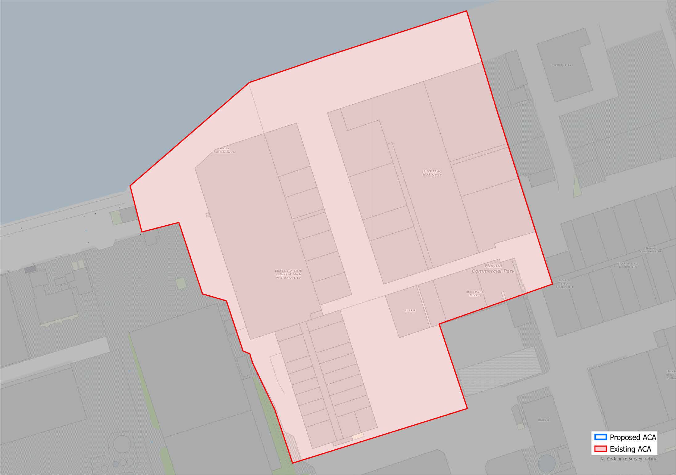
Former Ford Factory Site,
Marina Commercial Park
(Click on Map for High Resolution Image)

1.45
The area is bounded by the River Lee to the north, the extensive grain silos and fertiliser plants to the west, and the later re-development at the former Dunlop site and more recent Ford buildings to the east and south. The Architectural Conservation Area extends to contain the 1917 tractor plant, the 1929 extensions to east and west, and the electrical plant from the early 1930s.

1.46
The tractor plant, a protected structure PS1135, is the oldest structure on the site built between 1917 and 1919. It is of international historical, industrial archaeological, technical, and architectural significance as one of the first single-storey reinforced-concrete vehicle assembly plants in the world. It was designed and built by Ford engineers from Detroit where Henry Ford had developed the modern assembly-line production process and his designers were creating a new kind of industrial architecture to house it. The later structures on the site, of historical, architectural, and industrial archaeological significance, reflect the evolution of industrial architectural design.
1.47
The structures are located on a large flat site, essentially a polder reclaimed from the river, the lower section to the south set below the tidal highwater level, rising as it meets the river’s edge where the original Fordson tractor plant and concrete quayside have been constructed at a higher level to avoid flooding and to protect the lower land running back towards Centre Park Road.
1.48
The present character of extensive low-rise structures set in an orthogonal arrangement in a flat industrial landscape will change as the area is redeveloped and the uses are intensified.

1.49
The challenge is not to resist change but to ensure that new, higher density redevelopment reflects the industrial and historical origins of the site and retains its significance as part of a new conception for what will be a new urban quarter by the banks of the River Lee.
1.50
It is important to emphasise that the retention of the historical, architectural, industrial archaeological and technical significance of the site does not imply the retention of the entire extent of the low-rise historic industrial structures: rather that the retention of their significance places these significant structures at the centre of a new instensified spatial and architectural conception for the development of the site, as exemplified in the recent planning application for the site which the City Council granted in 2012.
ACA
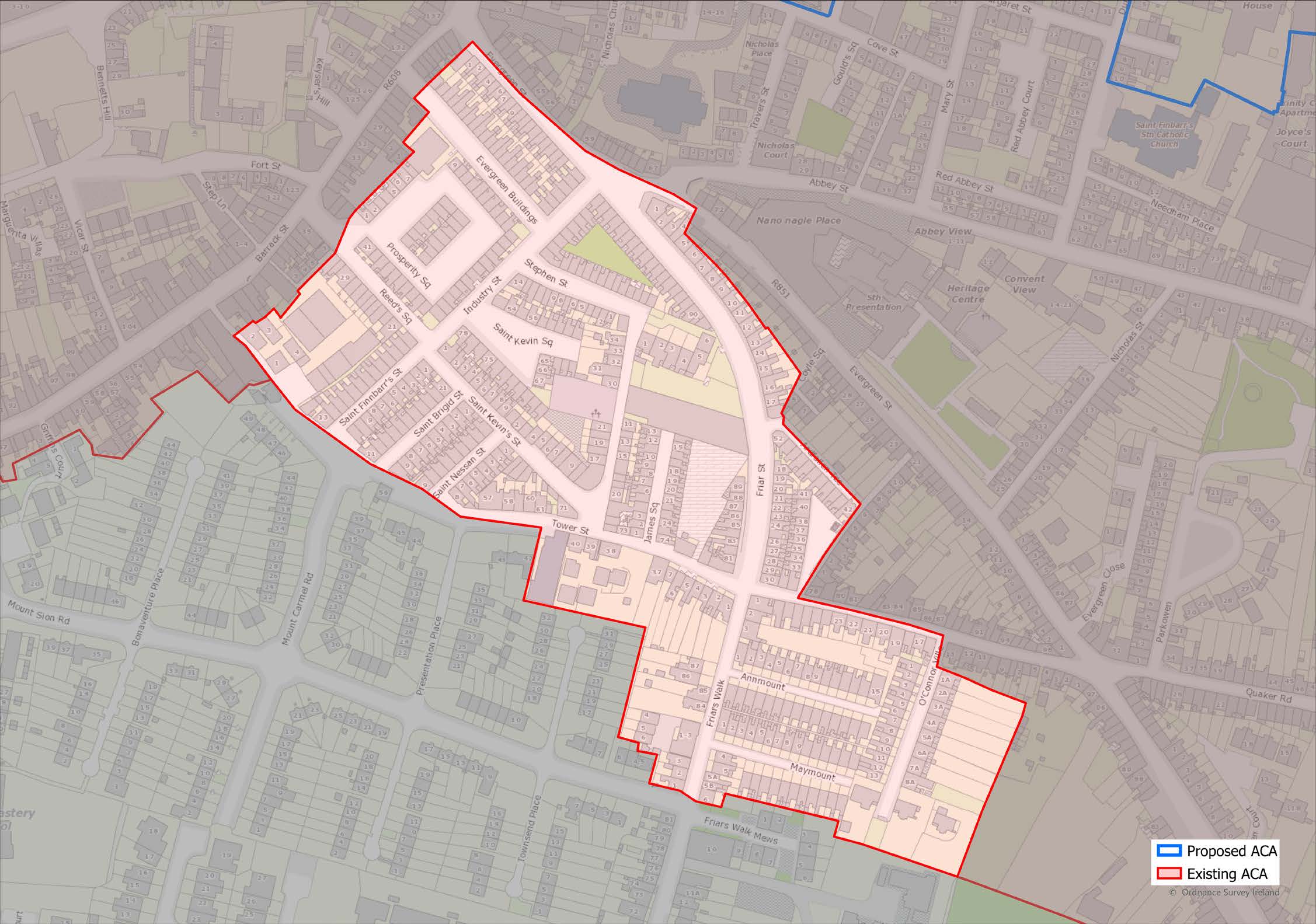
Friar Street Area
1.51
This area contains groups of improved housing schemes from the late 19th & early 20th centuries located to the south of Evergreen St. and to the east of Barrack St. They were built as a concerted effort to improve the standard of housing in the overcrowded traditional parts of Cork City. Many of the houses have attractive details typical of the architectural style of their time while others are simple and straightforward. All are generally formally designed in groups, are two-storey or one and a half-storey in height, of brick construction,(though many have been subsequently plastered) originally with natural stone slate roofs and timber windows.
(Click on Map for High Resolution Image)
ACA
Grattan Hill, Lincoln Place, Hackett’s Terrace
and Mahony’s Avenue

(Click on Map for High Resolution Image)

1.52
The area is located to the south of Middle Glanmire Road and to the north of the former railway corridor behind the Lower Glanmire Road. It is bounded on the west by the boundaries of St. Luke’s Church, Victoria Terrace, and Clarence Terrace, Lodge and Court; on the north and east by the large gardens of the houses entered off Middle Glanmire Road. The only one of these houses set in their own grounds, Westboro, extends from Middle Glanmire Road to Mahony’s Avenue, and is therefore included within the boundary of the area.

1.53
The area, of architectural and historical significance, comprises three distinct sections: Mahony’s Avenue, Hackett’s Terrace, entered between a gap in the houses of the lower part of Mahony’s Avenue,and Grattan’s Hill/Wellington Terrace/Lincoln Place and Riverview Terrace. The area within the boundary is overwhelmingly residential in character, one commercial user and a primary school being the only exceptions.
1.54
Mahony’s Avenue is the principal throughway in the area, off which Grattan Hill and Hackett’s Terrace are accessed. It is a single-sided street with grouped terraces of mainly 2-storey, 2-bay houses set behind walls and railings on the southwest side of the street. On the opposite, north-east side is the stone-boundary wall of the gardens of Westboro House, a Protected Structure, with extensive gardens containing mature trees and shrubs. At the upper end of the Avenue are structures originally associated with St. Luke’s Church - the Church of Ireland primary school and the former rectory.
1.55
Hackett’s Terrace is entered from the lower end of Mahony’s Avenue. Entered via a narrow entrance between the houses, it opens out on the south side of the homogenous terrace of south-facing 2-bay, 2-storey houses. The houses are in singleoccupancy residential use.
1.56
The area comprising Grattan Hill, Wellington Terrace, Lincoln Place and Riverview Terrace is located on the east side of Mahony’s Avenue and just to the north of the former railway corridor. It comprises principally 2 and 3 storey late Georgian and Victorian terraced houses, some in single-family occupancy, some sub-divided into self-contained units.
1.57
The blocks of houses are designed to face south, although the principal access is generally, but not always, from the street side irrespective of whether the house is on the north or south side. Many of the buildings are designed to look out over and be seen from a distance from the city centre and the south side of the river. The late-Georgian houses were built in the grounds of an older 18th Century house which was itself divided into two houses (now nos.1 & 2 Lincoln Place).

1.58
The buildings which make up most of the area are built of brick or stone, usually rendered in lime or old cement. Where houses retain original elevational features, they have timber sliding sash windows, roofs of natural stone slate and cast-iron rainwater goods. Many houses have architecturally composed boundary walls with doorways or gates, cast-iron railings, and external steps with metal handrails. The area contains significant lengths of footpaths, with stone steps, cast-iron railings and stretches of limestone-kerbing.

1.59
The area is undergoing change. Houses in multiple occupancy are being refurbished and returned to single-family use and into larger self-contained units. Others in multiple occupancy, are being upgraded, but some are not maintained in a manner appropriate to their architectural character. Car parking for residents is limited because of the narrowness of the streets. Mahony’s Avenue is used as a route from Lower Glanmire Road up to St. Luke’s Cross and into the city centre by many commuters impacting seriously on the amenity of local residents.
ACA
Greenmount
1.60
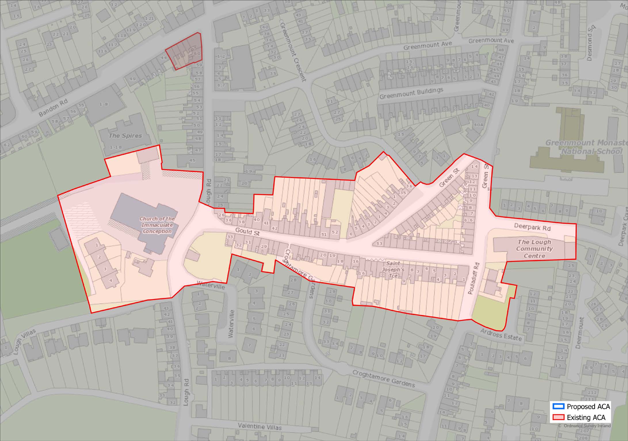
(Click on Map for High Resolution Image)
ACA
Lower Glanmire Road
1.61
The area comprising this ACA is bounded by Kent Railway Station and marshalling yards to the south, by the railway overbridge to the east and by the original line of the former to Cobh and Midleton railway to the north. It contains a variety of terraced house types but which generally date from the early to mid-19th Century. Some have railings and steps to the street, others are entered directly from the street. Most have painted rendered rubble-stone walls, originally with stone-slated roofs and timber sash windows. There are a number of buildings with attractive timber or tiled shopfronts set among the mainly domestic terraced houses of two to three principal storeys.
(Click on Map for High Resolution Image)
ACA
Mardyke

1.62
The Mardyke Architectural Conservation Area (ACA) is defined by a linear pattern of development, centred along the main thoroughfare running from The Maltings complex in the east to the grounds of the Sacred Heart Catholic Church on Western Road. It is bound to the north by the River Lee while the rear gardens of predominantly terraced housing shape the southern boundary of the ACA.

1.63
The linear street pattern of Mardyke Walk and Dyke Parade, running west-to-east, provides a strong framework which contains varied styles of architecture constructed from the 18th century to the present. It retains the character of a tree-lined avenue with historic elm trees along its length while the Constable’s Lodge hints at its past as a gated promenade. While the area is primarily residential in character with recreational and educational uses incorporated along its northern boundary on the floodplain of the River Lee, it is split into two distinctive sections by the junction of Mardyke Walk and Slí Chumann na mBan.
1.64
To the east, the area is made up of Dyke Parade and a portion of Mardyke Walk. Predominantly urban in character, it is characterised by its extensive roadway with wide pedestrian footpaths and orthogonal stands of trees. Its historic stock of Georgian and Late Victorian terraced houses is grouped together in formally designed terraces, and range from 3-storey on-street townhouses to more modest 2-storey dwellings with walled front gardens of varying finishes including smooth render, cut-stone with red brick quoins, some with limestone coping and often surmounted by wrought iron railings. The area contained between the roadway and the river is home to various important educational institutions including St. Josephs National School whose position almost directly on the street edge combined with its rough-rendered boundary wall with high wrought iron railing contributes to its prominence within its historic surroundings.
1.65
To the west of Slí Chumann na mBan, the area centred on Mardyke Walk is markedly different in character with a mix of recreational and residential uses. It is much smaller in scale and far less urban in character, contributed to by a more uniform cover of shrubbery and trees along the northern boundary of a more modestly sized roadway. The varying treatment of the boundary between private residences and the public domain is an important feature that affects the character of this area, whether that be the tall gates and garages of the rear gardens of large 3 and 4-storey buildings facing onto Western Road, the low rendered walls with wrought-iron railings of the front gardens of smaller Victorian 2-storey terraced dwellings facing onto Mardyke Walk or the higher pebble-dashed walls of mid-20th century semi-detached dwellings.
1.66
In contrast, the area north of Mardyke Walk is primarily recreational in character and is home to many historic sporting associations including the Sunday’s Well Boating and Tennis Club and the Cork County Cricket Club, the early 20th century clubhouses of which, both designed in the Colonial style, contribute to the character of the area. The important public amenity of Fitzgerald’s Park as well as the boundary of the UCC Mardyke Sports Complex, formed of dressed limestone walls with rendered coping and fine wrought-iron railings with trident motif combined with the turnstiles at the junction of Mardyke Walk and Western Road, are of social and heritage value and contribute to the varied historic character of the area.
ACA
Marie Place 1-12,
Windmill Road
1.67
An interesting terrace of 12 two-bay two-storey houses, built c. 1895 and located on the western side of Windmill Road. The gable fronted facades of this terrace contrast with the more regular facades in this area of the city and their scale and form make a positive contribution to the streetscape.
(Click on Map for High Resolution Image)
ACA
North Main Street
(Click on Map for High Resolution Image)

1.68
The area is centred around North Main Street and part of South Main Street. It is bounded on the east by the rear of (but not including) the properties on Grand Parade, Cornmarket Street, on the west by Grattan Street, on the south by Hanover Street, and on the north by part of Bachelor’s and Kyrl’s Quays.

1.69
In addition to its architectural significance, it is an area of the greatest historic and archaeological significance within the city’s boundaries and is therefore of civic importance for Cork. It is the site of the original medieval city with the present-day street and lane layout reflecting the early medieval burgage plots. The buildings are mainly of 18th and 19th Century origin built after the narrow medieval main street was widened. Beneath the current street and building fabric there is a rich archaeological repository of the City’s medieval past. The remains of the city wall are a recorded monument as is the entire below-ground archaeological zone.
1.70
North Main Street extends from Griffith Bridge (the former North Gate Bridge) in the north, which carries the road from Shandon to the river-island, to Castle Square in the south via the river-island. The road makes its way across the former river-island with a slight curve and a noticeable widening towards its southern end, characteristics typical of the medieval period. The road crosses a now culverted channel to the present day South Main Street and terminates at the former Castle Square.
1.71
The buildings on the western sides of Grand Parade, Cornmarket Street, Henry Street and Cross Street are built approximately along the line of the former city wall. These streets correspond with the river channels which formerly surrounded the walled medieval city and provided both access for trading and protection from attack.

1.72
Along North and South Main Streets, the buildings are mostly narrow fronted with long plots and with a laneway running between each pair of buildings. Many of the laneways are now incorporated into buildings as hallways or private accesses. Building heights are mainly between 3 and 4 storeys, with commercial premises on the ground floors. Buildings on the secondary streets are similar, but with a mix of commercial premises and domestic houses. Because of the narrow frontages, many businesses in North and South Main Street and the larger side streets extend across a number of buildings and plots.
1.73
External finishes are mainly painted plaster over brick and rubble stone walls, timber sliding sash windows, stone slated pitched roofs with cast-iron rainwater goods. A number of larger scale buildings are located at the northern end of North Main Street which provide city-wide leisure and shopping facilities in modern complexes. There are a number of institutional buildings within the area. Notable examples include the mid-20th century Franciscan and Augustinian Churches, the Catholic Young Men’s Society Hall, and the 18th century former Church of Ireland Parish Church, St. Peter’s (Cork Vision Centre) which is set-back from the street front, behind cast iron railings.

1.74
The area continues to suffer from the continuing decline of its traditional economic and social role despite the uplift generated by the 1994 Historic Centre Action Plan. That initiative needs to be followed up with a sustained effort on the part of the City Council, local residents, businesspeople, property owners and the general community who use the area.
1.75
The lack of integration with the modern commercial city district to the east is improving by way of planned upgrades to Cornmarket Street and by the coming on stream of the key retail opportunity site on the Old Guy’s site. The demand for ground floor retail space is growing but needs to be supported to ensure continued commercial vibrancy of the area. While narrow building frontages and the small scale of buildings make some modern uses difficult to accommodate the overall identity of the area needs to be strengthened so that the aera’s archaeological and architectural richness can be actively maintained.
ACA
North Mall and the Marsh

(Click on Map for High Resolution Image)

1.76
Located between the two principal channels, the North and South Channels of the River Lee, the area is essentially a marsh. Early maps show parallel intermediate water channels along Henry St. and Sheare’s St. which are now in-filled and/or culverted over. The area is bounded to the north by the rocky escarpment which forms the rear boundary of the properties along the North Mall. To the east the area abuts the North Main St. ACA centred around the former walled medieval city. To the west, the narrower neck of flat, low-lying land which contains Dyke Parade and the Mardyke.
1.77
The original Marsh was cut through in the early 19th century by Great George St. (now Washington St.) to a unified design by Sir Thomas Deane to connect the Grand Parade to Lancaster Quay and Western Road.
1.78
The ACA contains the largest group of large and mid-sized 18th century houses in Cork, the larger on both banks of the North Channel (North Mall and Grenville Place), the smaller houses along Sheare’s St. as well as an important designed group of unified buildings on Washington St. West. The largest and most imposing building is the former Lord Mayor’s Mansion House built in the mid-18th century, and in use as the Mercy Hospital since the mid-19th century. The character of the area changes adjacent to the South Channel where a significant number of the former industrial structures remain.

1.79
The area is of architectural, historical and adjacent to the South Channel, of industrial archaeological significance. It is structured as a series of linear spaces running generally east-west parallel with the river channels. On the north edge of the area, the mid-Georgian space centred on the North Channel contains large Georgian terraced houses, and in the centre, the in-filled former waterways of Henry St. and Sheare’s St. are lined with a mix of smaller 18th and early 19th century houses.
1.80
Washington St. contains the large-scale unified brick terraces of mixed use commercial and residential buildings built by the Wide Streets Commissioners, while to the south are the former industrial sites which abut the South Channel, e.g., the various structures associated with the Hive Iron Works. The Mercy University Hospital plays an important role in the evolving development of the area.

1.81
Buildings are typically constructed of painted plastered rubble-stone or brick walls, several with slate hanging on exposed elevations (as at Fenn’s Quay). Where they retain original finishes and features, they have roofs of natural stone slate, robust cast-metal rainwater gutters and downpipes and painted timber doors and windows and many good examples of iron railings and gates. Surviving historic street furniture and paving, such as stone quay walls, limestone steps and kerbing,

1.82
Commercial viability, vacancy and dereliction, flooding, and traffic passing through the area and visiting the hospital.
ACA
Paul Street

(Click on Map for High Resolution Image)

1.83
The Paul Street Architectural Conservation Area is located between Lavitt’s Quay, Cornmarket St., Half Moon St, Academy St. and St. Patrick St. It is predominantly commercial in character, with an emphasis on retailing and evening entertainment. Formerly an enclosed area of marshland bounded by offshoots of the River Lee, the area has largely retained its 18th century street pattern.

1.84
Paul Street is the principal thoroughfare across this former island, lined by 18th century buildings, on small scale plots interspersed with larger, mainly 19th century buildings. The area contains some larger 19th century buildings of significant architectural merit and some 20th century buildings of limited architectural value. It also comprises the Huguenot Quarter consisting of Paul Street, French Church Street and Carey’s Lane.
1.85
The area is of archaeological significance as it is located within the Secondary Zone of Archaeological Potential for the City. It contains two entries on the Records of Monuments and Places (RMP), The Huguenot graveyard site (CO074-111) and St. Paul’s Church (CO074-03502) and associated graveyard (CO074-03501).
1.86
Additionally, the area is of historical, architectural, and social significance for its connection with the Huguenots and as one of the first areas to be reclaimed from the marshes outside the medieval walled city. The original 18th street pattern has been retained and there are examples of building types from the different periods of the city’s development: from the early 18th century houses on Paul St., the 19th century stone warehouses of Carey’s Lane and French Church Street, the churches of St Paul’s, St. Peter and Paul’s and the former Methodist church on French Church Street.

1.87
The area is particularly rich in churches and ecclesiastical buildings of different denominations and in many different architectural styles. Theserange from the 18th century former St. Paul’s Church and churchyard, the relatively modest former Methodist Church set into French Church St., the imposing polychromatic SS. Peter & Paul’s Schools and Presbytery to the magnificent SS. Peter & Paul’s Catholic church by the architects E.W. Pugin and George Ashlin.
1.88
Traditionally, the more modest buildings in the area whether domestic, commercial, or industrial, and dating from the early 18th to the early 20th centuries, are generally constructed of painted plastered rubble-stone or brick walls. Where they retain original finishes and features, they have roofs of natural stone slate, robust cast-metal rainwater gutters and downpipes and painted timber doors and windows.

1.89
The area is under increasing pressure for redevelopment due to its innercity location with demand for large floor plates and for buildings to be combined, for example for retail, pub and restaurant uses.
ACA
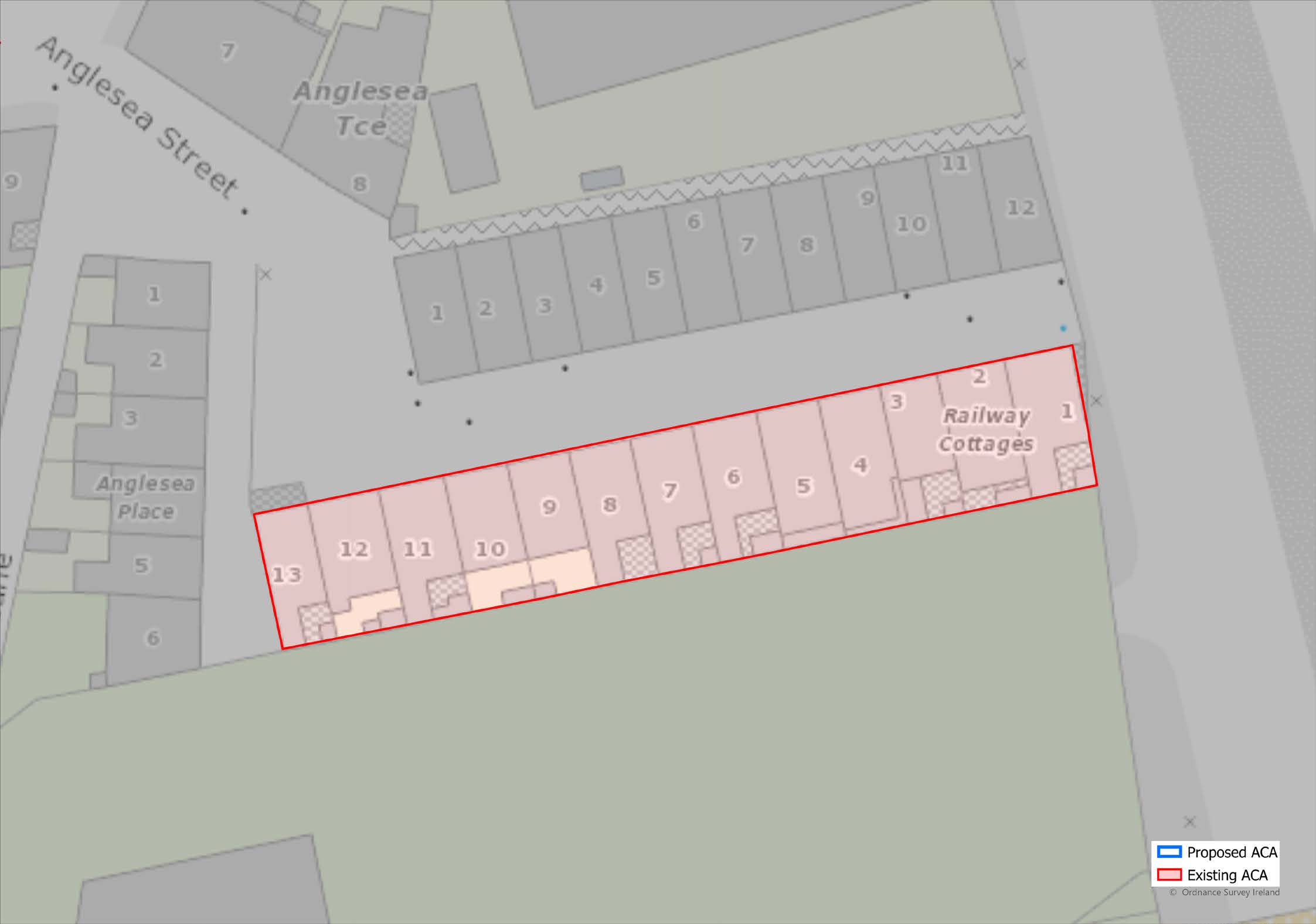
Railway Cottages
1-13, Anglesea Street
1.90
A terrace of 13 two-bay two-storey houses located in a cul-de-sac, built c. 1865-1868. Although altered and modernised they are important as part of a group which retain vernacular, even rural character and are important for the domestic scale of the area.
(Click on Map for High Resolution Image)
ACA
Rockboro Road 18-20
1.91
A terrace of 3 two-bay two-storey houses with attic, built c. 1870. They are significant for their building materials of silver Cork limestone and sandstone, more usually associated with much larger structures. This terrace is an interesting contrast within Rockboro Road which is generally lined by rendered houses.
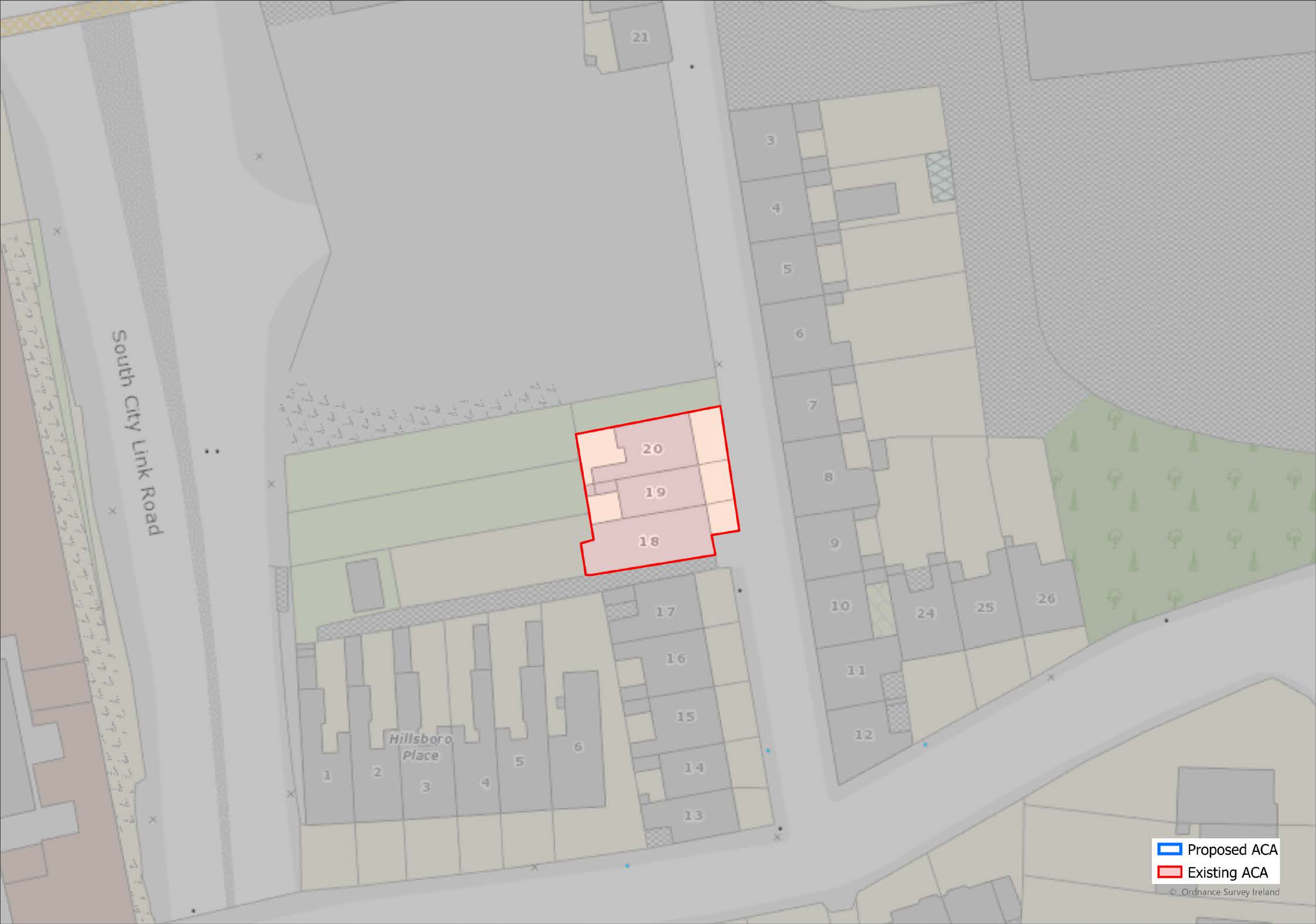
(Click on Map for High Resolution Image)
ACA
Shandon
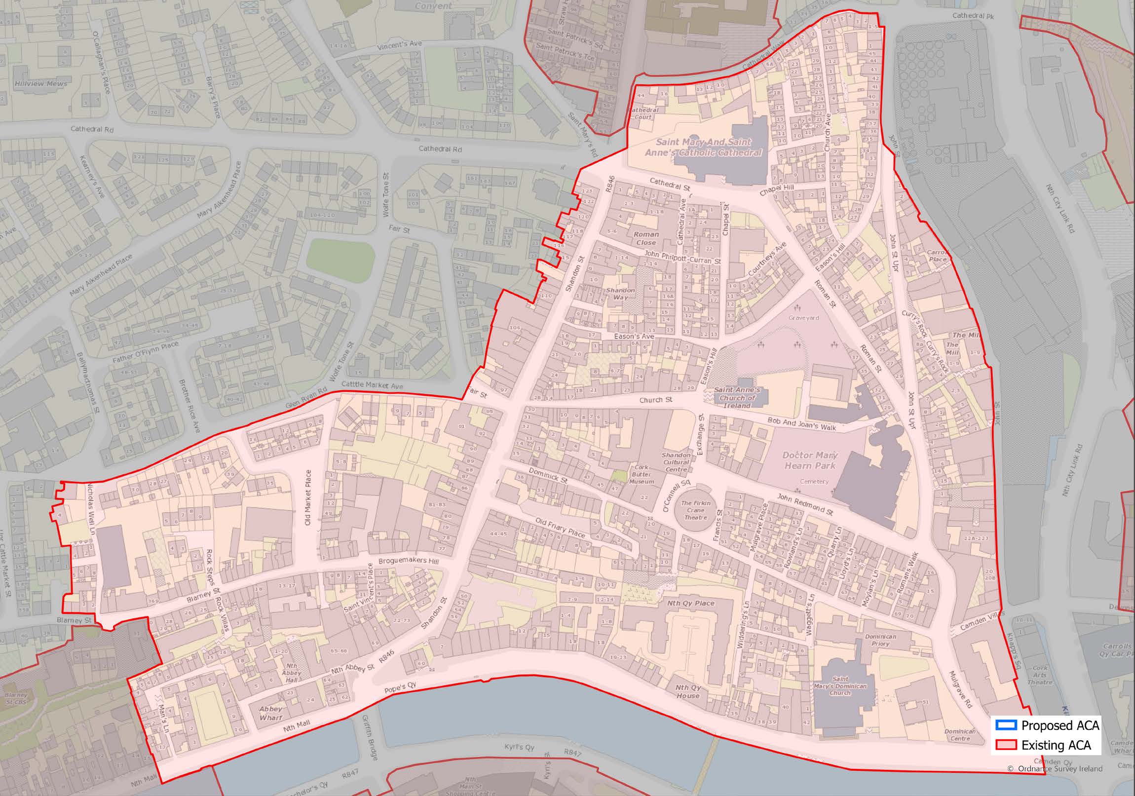
(Click on Map for High Resolution Image)

1.92
The area is centred around Shandon Street, originally known as Mallow Lane, which runs from North Gate Bridge, the entrance to the medieval city, steeply uphill to the ‘North Cathedral’, the Catholic Cathedral of SS. Mary and Anne whose great tower marks the point where the road north out of the city crosses the ridge
1.93
The area is bounded on the north by the North Cathedral, on the south by the North Channel of the River Lee, on the east by the valley of the Kiln River, along which the new Blackpool by-pass runs and on the west by the lanes around the former cattle market area on the rising ground above Blarney Street.

1.94
Shandon is an area of significant social, economic, cultural, and religious importance in Cork City. The area is compact and densely built up, housing a diverse range of activities in its 18th and 19th century buildings as well as in many more recent structures. It is an area that, though it has seen much change in recent years, still retains its historic pattern of streets, lanes and steps. 18th century workers’ cottages sit alongside modern infill developments while monumental buildings such as the Firkin Crane, the North Cathedral and the tower of St. Anne’s Church give the area its own unique identity and mark its presence on the city skyline.
1.95
The central thoroughfare of the area is Shandon St. running from North Gate Bridge up to the North Cathedral. It is a busy shopping street of mainly small narrow-fronted shops and pubs, and divides the area into two distinct parts, one to the west and the other to the east, each with a distinct character and history.
1.96
The eastern area containing John Redmond St., Exchange St., Dominick St., and Church St. functioned as the main trading area when Shandon was at the height of its importance for the provision trade and the export of butter. The lands to the west of Shandon St. and to the north of Blarney St. were historically associated with the cattle trade, cattle being brought to the edge of the city, kept on land now covered with 20th -century houses, before being sold in the cattle market, slaughtered and prepared for consumption or cured for export on board ships.

1.97
The dense network of streets, lanes, archways and steps, running throughout Shandon contain numerous styles of domestic architecture, though the area is better known for its important monumental historic buildings, including the Firkin Crane, former Butter Market (now the Craft Centre), Skiddy’s Almshouses, St. Anne’s Church, its tower perhaps the city’s defining image.
1.98
As is traditional in the area, buildings are generally constructed of rubble-stone or brick, usually rendered and painted. The variety of architectural styles is evident when considering the different scales, heights, and forms of the buildings present. They vary from the imposing three-storey terraced houses found at Pope’s Quay and Upper John Street, to the largely two-bay, two-storey houses lining the narrow streets and laneways that traverse the area. Good examples of early vernacular artisan housing are found at Waggett’s Lane and in the ladder of streets between John Redmond St. and Dominick St. The three-storey commercial buildings lining Shandon Street have some fine examples of traditional timber shopfronts.
1.99
18th century gable fronted buildings are a distinctive feature of the architectural heritage of the area and are now rare outside Cork city. Early examples of these are found at the upper end of Shandon Street and a terrace of two-storey, two-bay gable fronted dwellings exist at Francis Street. There are also several examples of good recent architecture including several attractively designed and scaled local authority and private infill housing schemes, proof that areas can evolve while still respecting their historic character. Where buildings have retained their original features and finishes, they have painted plastered facades, roofs of natural stone slate, cast-iron rainwater goods, and painted timber doors and sash windows.

1.100
Largely due to the densely packed housing, street layout and topography of the area, the potential for public open spaces has been limited in Shandon. However, there are plans to provide public parks in the graveyards associated with St. Anne’s Church, which will greatly improve the amenity of the area. A relatively high transient population and an increase in multiple occupancy rented housing, added to the narrow and restrictive nature of the street layout, has exacerbated the already difficult problem of car parking for local residents. It is important that this situation is improved in order to encourage more long-term residents. A number of prominent buildings on Shandon Street are in a poor state of repair or have suffered dereliction in recent years. The City Council will make use of its powers to help prevent further dereliction from occurring while at the same time resolving the existing situation by encouraging suitable development and repair works that appropriately reflect the character of the area.
ACA
South Parish
(Click on Map for High Resolution Image)

1.101
The South Parish Architectural Conservation Area (ACA) is located to the south of the South Channel of the River Lee and to the north of Evergreen Street. It is bounded on the west by the southern end of Anglesea Street, Infirmary Road and Langford Row and to the east by the southern side of Barrack Street.

1.102
There are 4 distinct sub areas within the ACA:
ACA South Parish
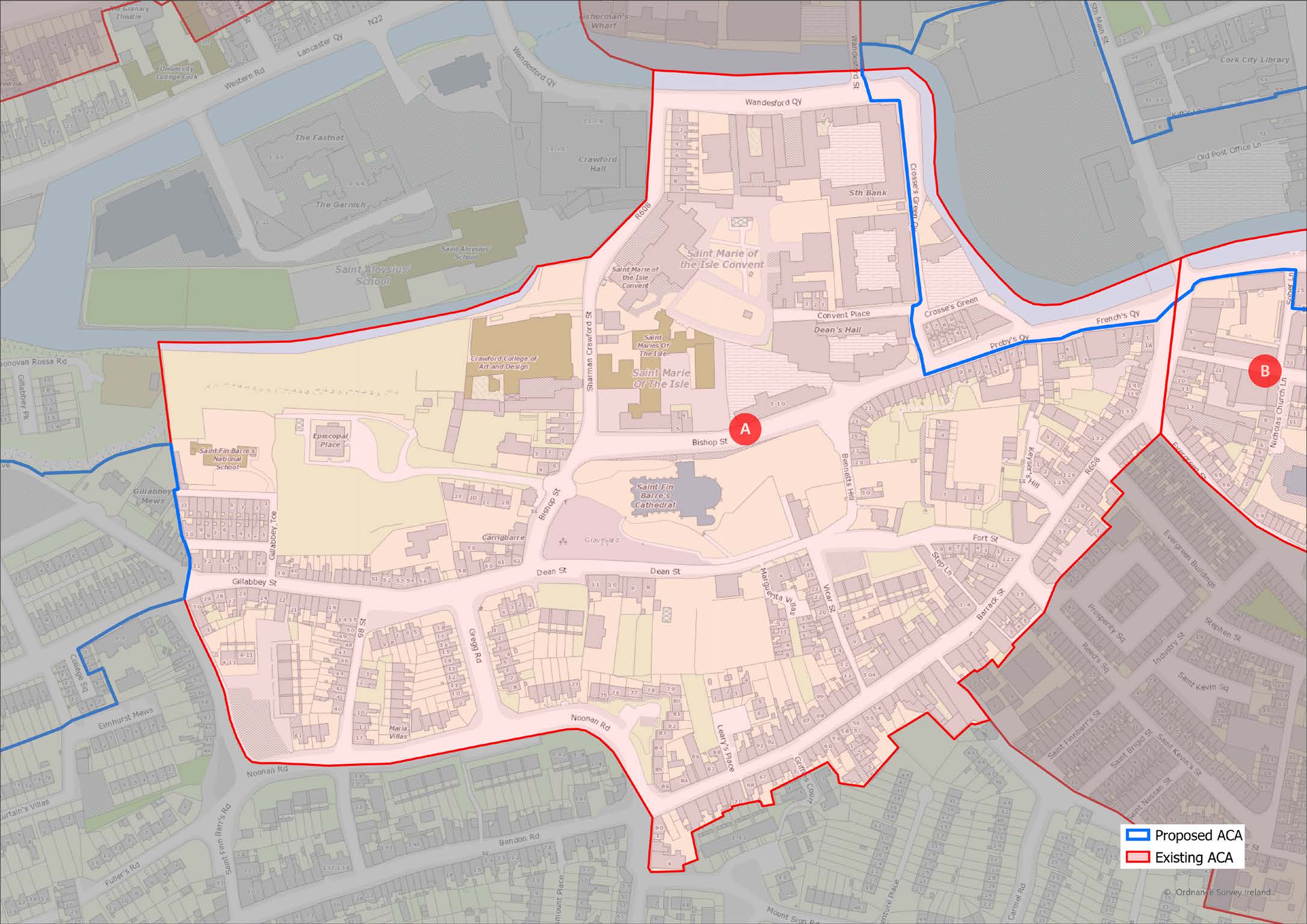
Sub-Area A: Cathedral
Quarter
1.103
This sub-area, of archaeological, historical, architectural and social significance, is located around the ridge containing Elizabeth Fort on the west, St. Fin Barre’s Cathedral at its centre, the 18th century Diocesan Library, sets of walls, railings and gates to the Cathedral and the 18th century Bishop’s Palace on the east. Dean St. immediately adjacent to the north contains terraces of 18th century houses originally associated with the Cathedral precinct. The sub-area is bounded on the south by the buildings of Barrack St., the curving form of the street plots reflecting the original monastic enclosure of the Celtic monastery.
(Click on Map for High Resolution Image)
ACA South Parish
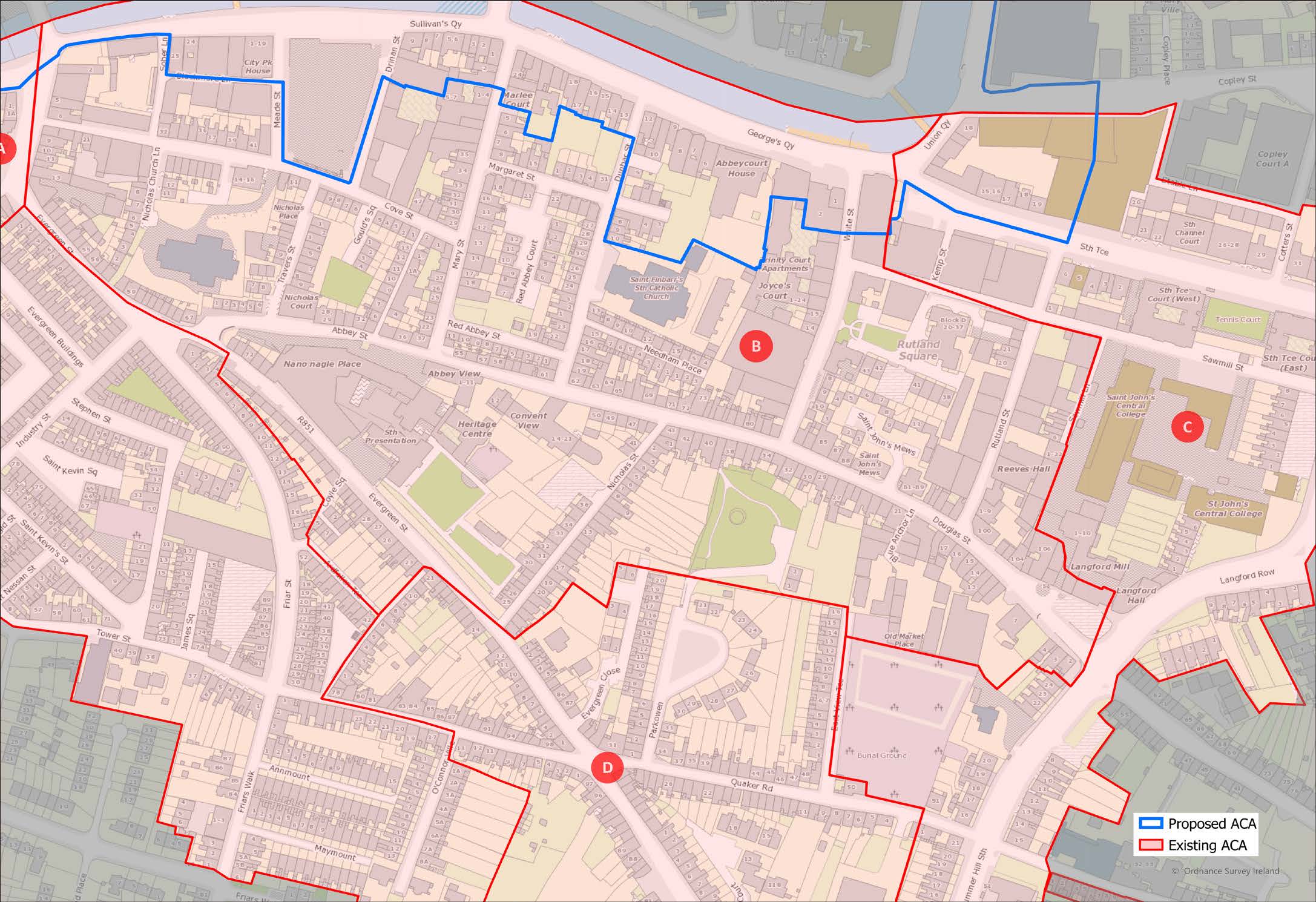
Sub-Area B:
18th Century streets
between Evergreen St
and South Channel
1.104
This sub-area, of archaeological, historical, architectural and social significance, is characterised by its grid of regular streets running between the older arterial roads leading into the old city (Evergreen, Douglas & Abbey Streets) and the subsequently developed quaysides of Sullivan’s Quay and George’s Quay (originally Roche’s Quay). The buildings located in this grid of streets vary from large 3 and 4-storey mid-18th century Georgian style buildings on the quaysides some with brick façades, cut-stone detailing and metal railings, to more modest 18th and 19th century terraced houses in the streets behind. However many of these still have late-Georgian details to doors and windows. The area also contains a number of religious institutions, churches and schools set on larger sites between the terraced houses, including the ruined Red Abbey tower of the former Augustinian friary, the oldest standing structure in the city.
(Click on Map for High Resolution Image)
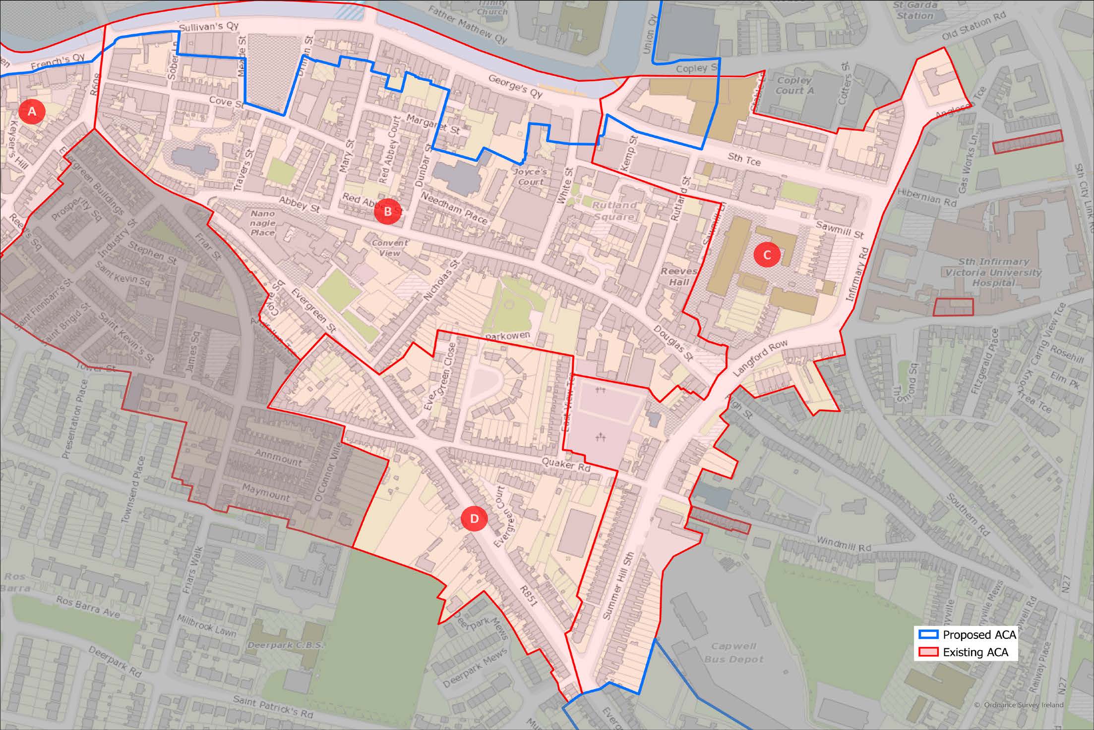
ACA South Parish
Sub-Area C:
Infirmary Road and
Summerhill South
1.105
This sub-area of historical, architectural and social significance, is located on the east side of the subarea B. It is an area of 19th century housing and institutional development on larger sites, largely made available by reclamation of the river marsh following the gradual construction of the Navigation Wall in the later 18th century. The sub-area contains a mixture of larger coherently designed brick terraced houses (many of which are protected structures, South Terrace, Newenham Terrace, terraces along Summerhill), interspersed between the religious and social institutions-among them the protected structures of former St. John’s Church and schools, Langford Place and SS. Joachim & Anne’s home.
(Click on Map for High Resolution Image)
ACA South Parish
Sub-Area D:
Evergreen Road,
Quaker Road

1.106
This sub-area consists of informally designed housing set out along medieval & post-medieval arterial routes to the old city. Its character is given by the eclectic but attractive mix of house types, sizes and styles, varied but coherent. Set into larger sites among them are schools, churches and old graveyards. Typically, buildings are built of brick or rendered rubble-stone originally with stone slate roofs and timber windows and doors.

(Click on Map for High Resolution Image)

1.107
The area is particularly rich in churches, ecclesiastical and religious school buildings of many different denominations and in many different architectural styles. These range from the site of the former Dominican monastery at Crosse’s Green to the ruined Red Abbey tower, from the 18th century structures in the South Presentation Convent site, Church of Ireland Bishop’s Palace, St.Finbarr’s Catholic Church (the oldest in the city), the Quaker graveyard, to 19th century buildings such as Sullivan’s Quay former Christian Brothers school, St. Nicholas Church of Ireland church, St. Mary of the Isles school and convent and of course, St. Fin Barre’s Cathedral. Traditionally, the more modest buildings throughout the sub-areas, whether domestic, commercial or industrial, and dating from the early 18th to the early 20th centuries, are generally constructed of painted plastered rubblestone or brick walls. Where they retain original finishes and features, they have roofs of natural stone slate, robust cast-metal rain water gutters and downpipes and painted timber doors and windows. Where historic street furniture or paving survives, such as limestone steps or kerbing, iron handrails etc., it is important for the character of the area that these are retained.

1.108
The area has a wide range of house types and local facilities including shops, pubs, schools and recreation spaces. However, the area is under increasing pressure from traffic, has difficulties with parking and has a poor-quality public realm which detracts from its amenity for residents and businesses. It is important that this be improved to encourage greater use of the existing building stock in a way that makes best use of its potential. There are also some vacant and under-utilised plots in the area, with scope for development to increase amenity and to reinforce the strong existing of the area.
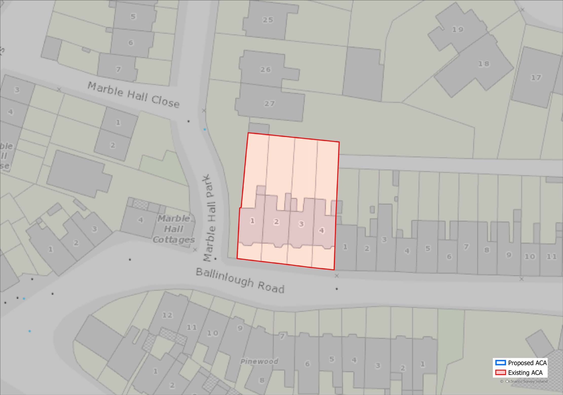
ACA
Vendeville 1-4,
Ballinlough Road
1.109
A terrace of 4 two-bay two-storey houses, built c.1911, as a private development, located on the north side of the Ballinlough Road. They are a very intact and charming group of early 20th century houses which retain their original roofline, iron railings and gates to the front.
(Click on Map for High Resolution Image)
ACA
Victoria Road
1.110
This group includes houses in Grand View Terrace, Woolacombe Place, Park Villas, Parkhurst, Victoria Road, Landsdowne Villas and Park View. They are a mixture of house types comprising detached, semidetached and terraced buildings and vary from twostorey to three-storey in height, some with attics. They are significant as a group of late 19th century houses retaining their original form and features and provide the area with a distinctive quality. Although the houses that make up this ACA show a variety of styles and forms they have an overall architectural coherence because of the shared elevational treatment and the brick and stone front walls with attractive ironwork which give a unified expression to the road.
(Click on Map for High Resolution Image)
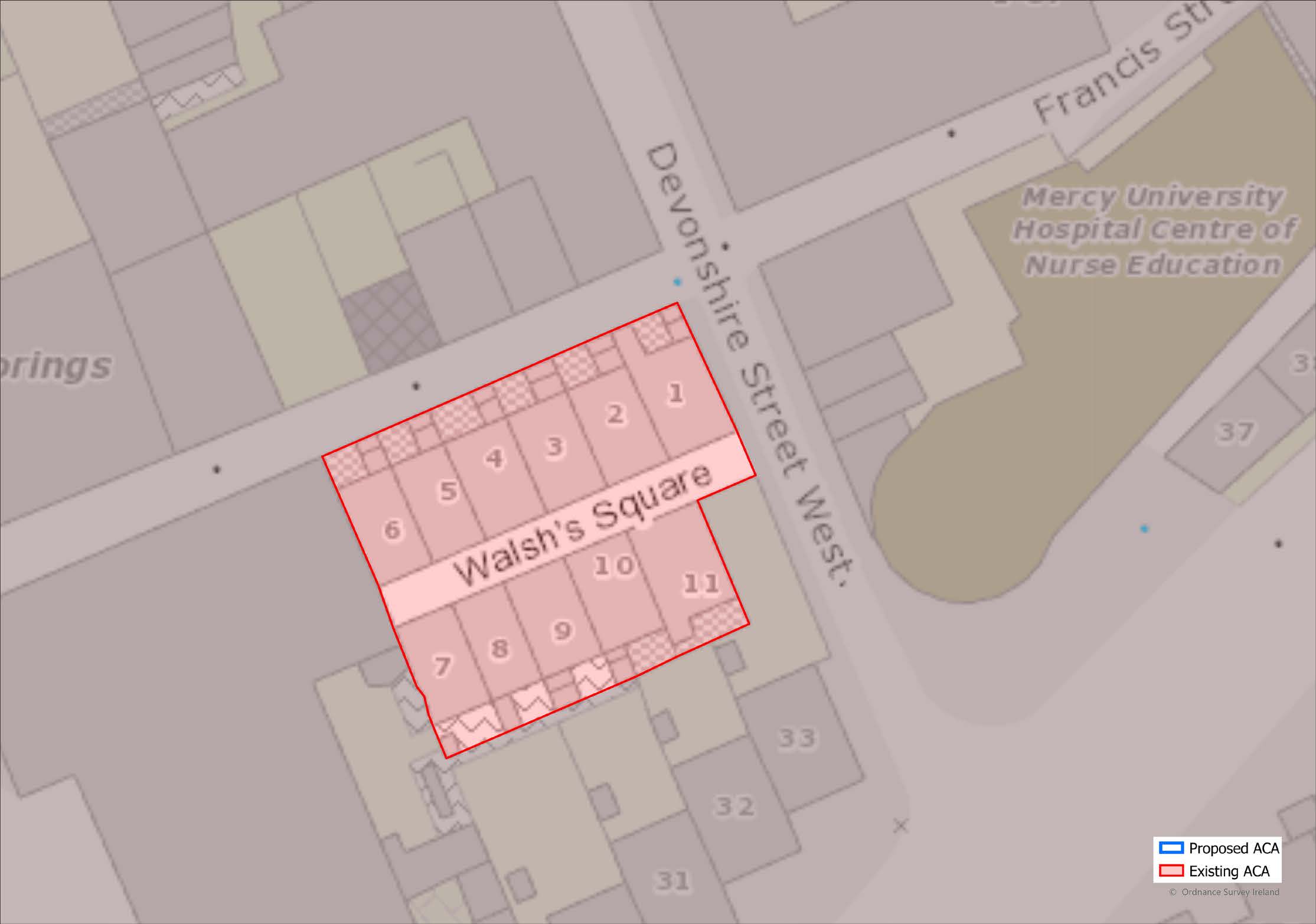
ACA
Walsh’s Square,
Devonshire Street
West
1.111
A small residential enclave comprised of 11 houses organised as two parallel rows of two-bay single storey with attic artisan vernacular houses. The development dates from 1883 with a number of houses subsequently added in c.1900. These houses are a notable example located in the heart of the city of modest workers housing grouped around a narrow lane which is typical of Cork.
(Click on Map for High Resolution Image)
Proposed Modification of Existing Architectural
|
| Blackrock Road |
| Blarney |
| Douglas - Donnybrook |
| Sunday’s Well |
| University College Cork, College Road and Magazine Road |
| Wellington Road and Saint Luke’s |
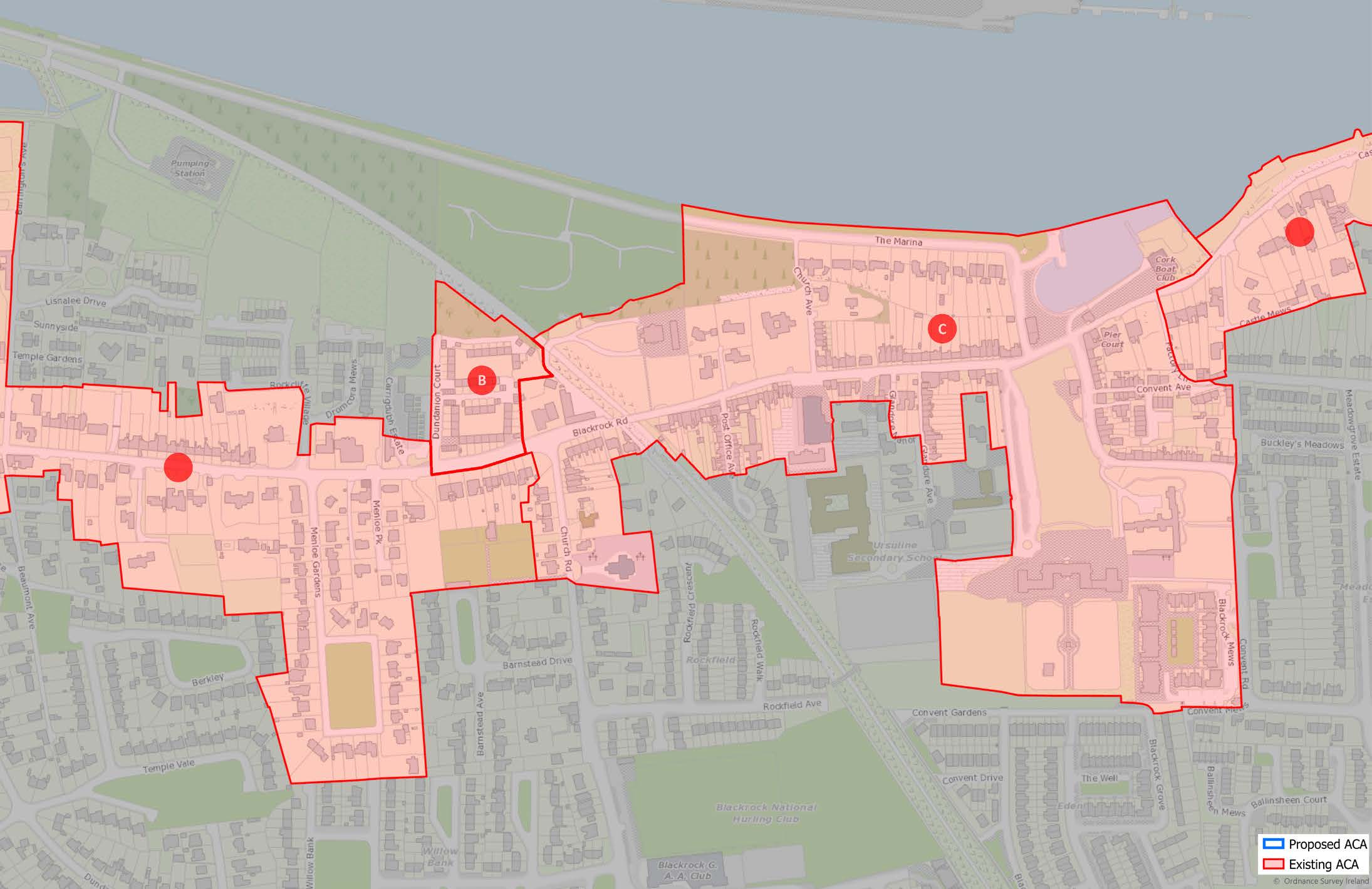
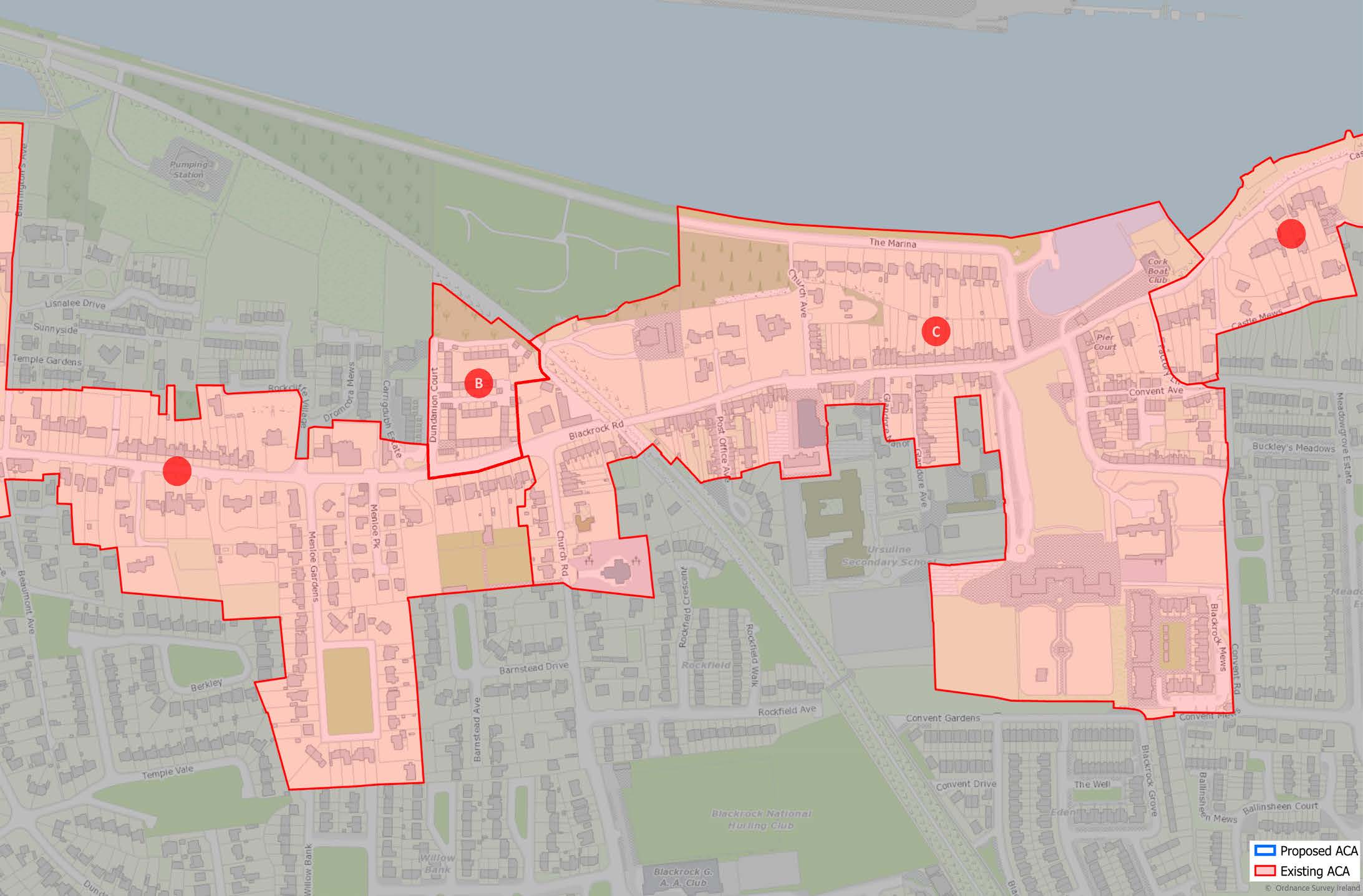
ACA
Blackrock Road
(Click on Map for High Resolution Image)

1.112
The Blackrock Architectural Conservation Area (ACA) is proposed to be extended westwards as far as the junction with Victoria Road, taking in St. Joseph’s Terrace as part of the Sub-area A.
1.113
The ACA is centred on the main thoroughfare of Blackrock Road running from junction with Victoria Road in the west to Blackrock Castle in the east. Its northern boundary is defined by the escarpment adjacent to the southern bank of the River Lee while the south is bound by the rear gardens of the terraced dwellings in Ballintemple and the villas along Castle Road. The southern boundary also takes in various ecclesiastical buildings such as the Ursuline Convent and its associated Chapel and grounds, St. Michael’s Church of Ireland Church and St. Michael’s Roman Catholic Church.

1.114
There are four distinct sub-areas within the ACA:
ACA Blackrock Road
Sub-Area A:
Ballintemple Village
and Surrounding
Suburbs
1.115
This sub-area, of historical, social and architectural significance, is characterized by its linear street layout along Blackrock Road and for its stock of buildings from the 18th to 20th century. The large Georgian houses along its northern boundary are sited to maximise their picturesque riverside proximity and lie within gated enclosures with clear boundaries between the public and private realm.
1.116
Blackrock Road is also sprinkled with gate lodges whose positions mark the former entrances to the grounds of these large residences. These simple structures have retained many original design features which contribute to the overall character of the streetscape. In contrast to the large riverfacing houses, the roadway is lined with terraced and semi-detached dwellings, sharing a direct relationship with the road with front gardens featuring ashlar, cut-stone or roughcast rendered walls with wrought-iron railings, demonstrating an evolving urban character. Despite their differing scales varying from 1 and 2 storey early 19th century small scale Georgian style buildings to larger three storey Georgian dwellings, their front elevations maintain much of their original character with unusually fine joinery, decorative door cases and fanlights, displaying a strong emphasis on craftsmanship.
1.117
At the heart of this sub-area lies Ballintemple Village whose small scale on-street terraced housing and shopfronts are a stark contrast to the set-back, gardenfronted houses of the surrounding area, giving a sense that the buildings contain the street contributing to the distinctly urban feel.
ACA Blackrock Road
Sub-Area B:
Dundanion Court
1.118
Dundanion Court, in contrast to the character of the rest of the area, is an example of a high-quality mid- 20th century housing scheme. It is a prime example of Modernist architecture whose façades feature fine detailing such as cedar external cladding and polished aluminium letter plates. The layout of the development includes external elements that are complementary to the architecture and intrinsic to the character of the area, including: communal soft courtyard spaces providing amenity, and narrow streets and parking courts.
(Click on Map for High Resolution Image)
ACA Blackrock Road
Sub-Area C:
Blackrock Village
1.119
This sub-area is centred on Blackrock Pier which also serves as a focal point for the village centre. Early 19th century terraced housing along Church Road, provide a fine example of Edwardian suburban housing, many retaining much of their architectural detail with well executed renderdetailing being of particular note. The influence of the art and craft movement is apparent in the design of the larger semidetached dwellings along Blackrock Marina, many sporting river-facing balconies. The area also contains a number of religious institutions, churches and schools, set on larger sites set back from the terraced dwellings and shops including the 18th century Ursuline Convent and its grounds. As an important Catholic building of its time, it was designed to be viewed from the river and the northern side of the river valley and served as a symbol of Catholic resurgence and power in a time of fading religious contention.
(Click on Map for High Resolution Image)
ACA Blackrock Road
Sub-Area D:
Castle Road
1.120
A strong feature of this sub-area is the cut-stone boundary wall with rounded capping running along the roadway from the east of Blackrock Village along Castle Road to Blackrock Castle. It also retains the limestone kerbing of the footpath which adds to the character of the streetscape. The roadway is lined with largely detached riverfacing Georgian housing, although many were altered during the Victorian period. Many retain their original architectural detailing and have boundaries featuring smooth render walls with limestone coping, often surmounted by wrought-iron railings and some with original pedestrian cast-iron gates. The area also has a high landscape value due to its tree canopy in larger gardens and the very attractive natural treed landscape along the riverside framing views of Blackrock Castle.
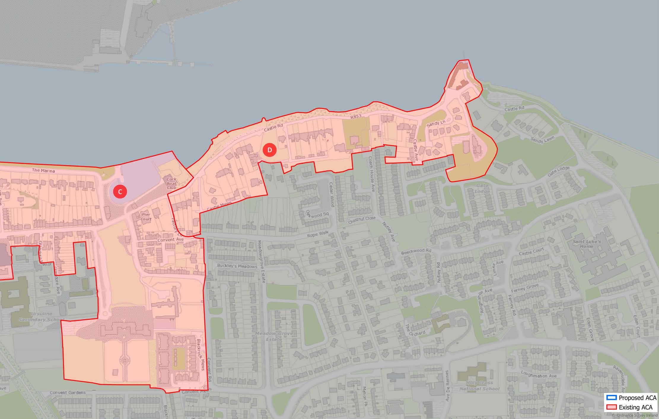
(Click on Map for High Resolution Image)

1.121
Predominantly residential in feel, with the exception of the village centres and a selection of ecclesiastical and educational buildings centred mainly on Blackrock village, the ACA has a rich stock of buildings dating from the 18th to 20th century, whether domestic, commercial or religious.
1.122
The residential buildings which make up most of the area are built of brick or stone, usually rendered to varying finishes i.e., smooth or roughcast. Where dwellings retain original elevational features, they have roofs of natural slate with terracotta ridge tiles and redbrick chimney stacks with clay chimney pots, stone sills, and fine joinery especially of door cases and fenestration. Also of note are the boundary treatments of these residential dwellings featuring ashlar walls or smooth render walls with limestone coping, often surmounted by cast-iron railings and some with pedestrian cast-iron gates and many with original engraved limestone plaques. Castle Road also features limestone kerbing which is an important feature to protect and retain. Interestingly, the modernist suburban housing of Dundanion Court offers a sharp contrast to the original historic dwellings as well as the various infill developments that have occurred over the years. It is under this merit that it should be protected as it represents the evolution of mid-20th century suburban housing.
1.123
The ACA is rich in churches and ecclesiastical buildings of different denominations and many different architectural styles, reflecting the religious, social, and physical expansion of the area over time. These range from the 18th century Ursuline Convent and T-plan chapel designed by Rev Michael Augustine Riordan, St. Michael’s Church of Ireland Church designed by the Pain Brothers to St. Michael’s Roman Catholic Church designed by James Rupert Boyd Barrett and commissioned by Bishop Lucey of Cork in 1960. Blackrock Castle sits on the most eastern boundary and is a landmark riverside 19th century building.

1.124
The area has a wide range of housing types and local facilities including shops, schools and churches. However, the area is under increasing traffic pressure, has difficulties with parking as well as pedestrian and cyclist safety, and has poor public realm especially in Ballintemple and Blackrock villages which detracts from its amenity for residents and local businesses. It is important that the condition and character of the existing building stock be maintained as well as the integrity of the streetscape and the riverside landscape.
ACA
Blarney

(Click on Map for High Resolution Image)

1.125
Blarney ACA is based on the significance and character of Blarney Castle Estate and the original industrial village. Blarney village was a designed village established in the late 1700s arranged around a central green, lined with modest houses and with a Church of Ireland church to the North. The village continued to expand during the 19th century with terraces of workers housing being developed in association with the expansion of the Mills which became the largest integrated mill in Ireland.

1.126
Blarney is a rural village dominated by two large heritage tourist attractions, Blarney Castle and Blarney Woollen Mills. The character of the 18th century village design arranged around a central green has survived well and remains the central focus of the village with shops, an hotel and houses surrounding the green. The entrance to the Blarney Castle Estate is on the south side of the green at the former terminus of the Cork and Muskerry Light Rail. The Mills are located to the East of the square. The River Martin skirts the south of the square and is the principal reason for the location of the Mills and village.
1.127
The character of the 18th century village design arranged around a central green has survived well and remains the central focus of the village with shops, a hotel and houses surrounding the green. The entrance to the Blarney Castle Estate is on the south side of the green at the former terminus of the Cork and Muskerry Light Rail. The Mills are located to the East of the square. The River Martin skirts the south of the square and is the principal reason for the location of the Mills and village.
1.128
The character of the ACA is varied. The bulk of the built heritage stock dates to the 18th and 19th century. The Blarney Castle estate character is defined by the traditional demesne landscape of farming landscape, native woodland areas with formal, designed gardens and the monument at the heart of the estate: Blarney Castle. The character of the estate is defined by its recreational/ tourist attraction status.

1.129
The building stock is varied. Blarney Estate has a mixture of buildings from the Medieval Castle, the stables, the 19th century Country House, gate lodges and associated structures.
1.130
Blarney Woollen Mills building typology is defined by the 19th century industrial buildings and residential buildings associated with the Mills. Residential structures arranged around the central green typically date to the eighteenth century when the village was first laid out. The cottages are single storey 3 bay dwellings with central door opening onto the street. Pitched natural slate roofs, cast iron downpipes, rendered elevations with chimneys punctuating the plot divisions define their character. The eastern side of the green have higher buildings, generally of 2 storeys. The buildings here have been altered with shopfronts inserted in some instances. The Church of Ireland, Church of the Resurrection, is located on the North side of the green and was built as part of the original village design layout.
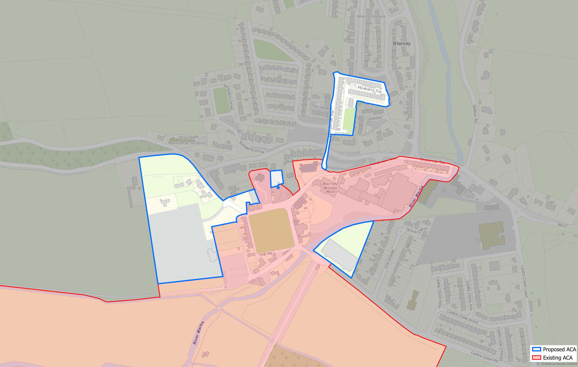
(Click on Map for High Resolution Image)
1.131
The Mills are large, exposed stone industrial structures generally of 3 or 3-and-a-half-storeys in height located on the banks of the River Martin. The workers dwellings of two storeys were developed in 5 terraces during the 19th century and have interesting, curved roofs with Belfast Trusses originally clad with roofing felt and bitumen. The cottages were designed to have exposed stone elevations, overhanging eaves with cast iron rain goods which survive in some instances. Each cottage on the terraces has enclosed front and rear yards.
1.132
The terminus of the Cork and Muskerry Light Rail located at the entrance to the Blarney Castle Estate. Several timber-clad buildings survive, in addition to platforms and turntables.

1.133
The historic character of Blarney village and estate has survived relatively well, however, modern, insensitive development in the area has had a negative impact on the special character of the place. The Castle, Mills and Village are of national and international significance and any future development should take this into account. This requires that development and associated landscaping be of sympathetic scale, materials, use and design.
1.134
The Mill cottages have been altered usually by extensions at ground floor level and the replacement of original timber windows with PVC equivalents. Some of the structures have been rendered or painted. Further unsympathetic extensions or upgrading works will have a negative impact on the historic character of the terraces.
1.135
Development adjacent to the village would require that visitor and local needs be balanced, however, the opportunity exists to further enhance the historic character of the village with every development proposal.
ACA
Douglas - Donnybrook
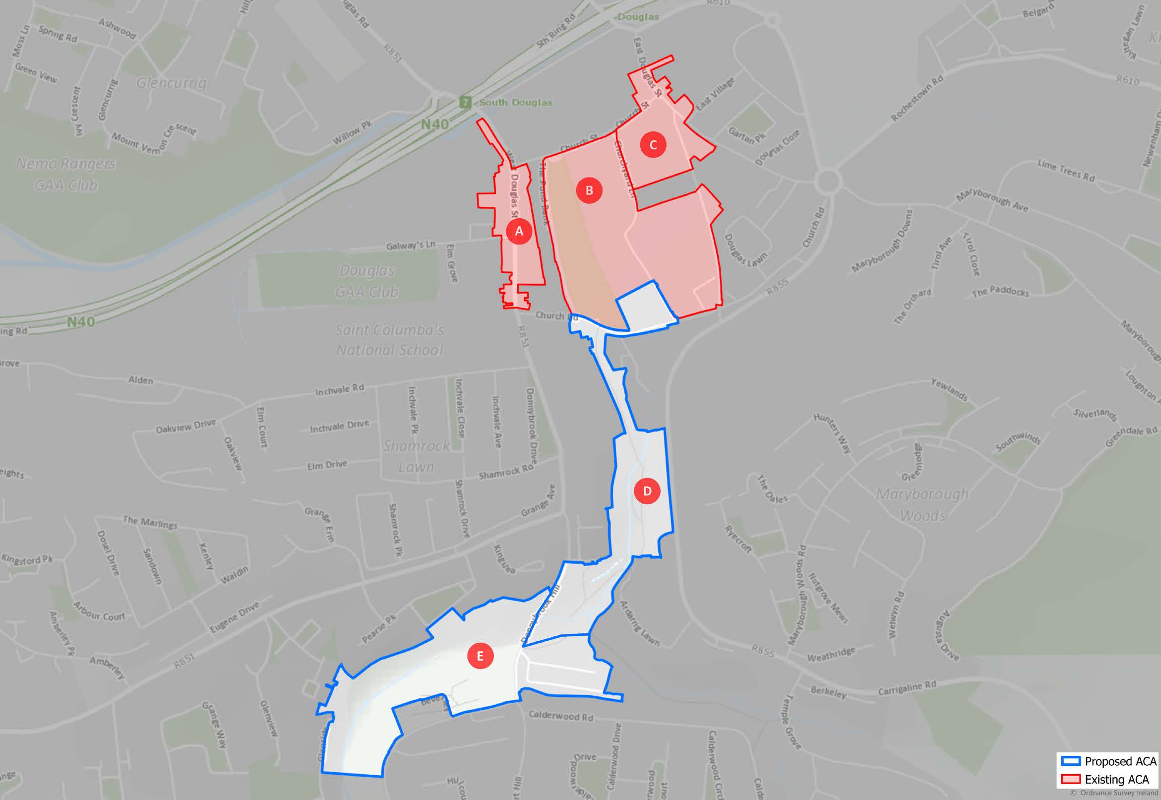
(Click on Map for High Resolution Image)
1.136
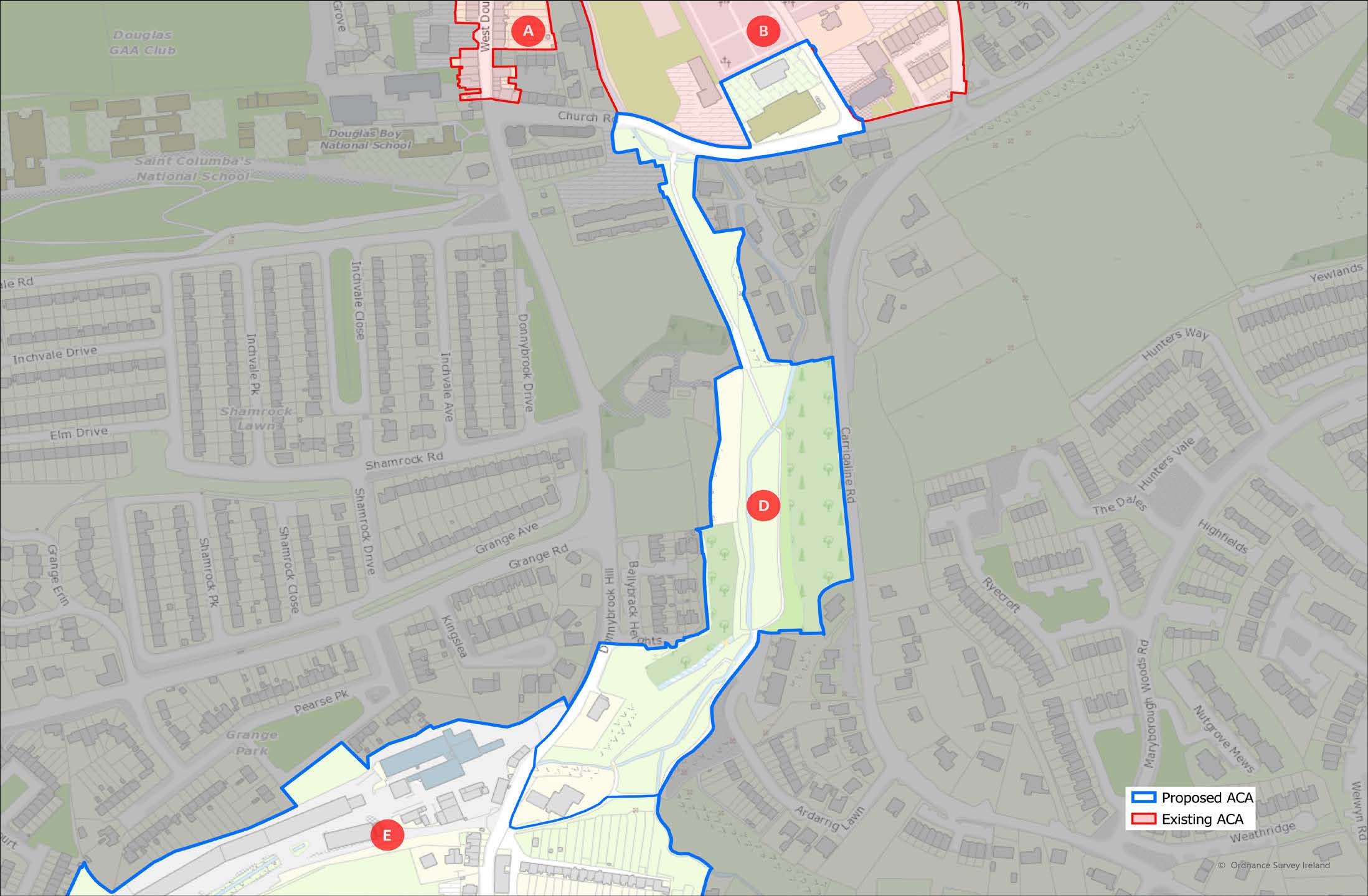
The Architectural Conservation Area contains five sub-areas corresponding to the different elements – industrial, ecclesiastical, and commercial - which constitute the historic Douglas-Donnybrook villages.
ACA
Douglas-Donnybrook
Sub-Area A: Douglas
West

1.137
West Douglas is a flat area bounded by the former mill pond on the East and is located between the Tramore River (subsequently site of St. Patricks Woollen Mills) to the North and bottom of Grange hill to the South.

1.138
This clearly historic street is lined by single storey, 3 bay cottages opening directly onto the street with gardens to the rear. The western side of the street was established by the early 19th century with later infills during the 19th century which reflects the expansion of the various mills in the area.

1.139
The building stock is characterised by early 19th century vernacular, rendered terraced dwellings. Typically, 3 bays with central door opening onto the street. Pitched natural slate roofs, cast iron downpipes, rendered elevations with rendered chimneys punctuating the plot divisions.
1.140
There is a grouping of 7 dwellings at the northern top of Douglas West which are associated with St. Patricks Mills. These differ in typology being formally designed, of coursed limestone with brick window and door surrounds.

1.141
There is pressure to develop the land behind the cottages leading to alterations or loss of the historic, vernacular, street front buildings. Currently some of the historic character to the street has been lost through inappropriate alterations (alterations to roof, insertion of modern shop fronts etc) or demolition and replacement.
1.142
Upgrading/ renovating the structures has meant loss of original windows and doors, cast iron rainwater goods being replaced with plastic and in some instances the replacement of natural slate roofs and the removal of the chimneys which interrupts the plot rhythm. This street is the main access route from the city to the southern suburbs of Grange and Donnybrook. Very heavy two-way traffic along Douglas West makes it difficult to appreciate the character of the area and being predominantly residential, the noise and pollution associated with traffic makes it difficult and uncomfortable for residents on the street.
ACA
Douglas-Donnybrook
Sub-Area B:
Douglas East

1.143
This area is located at close to the estuary on low-lying ground above the bridging point of the Tramore River. Historically the area was the centre of commercial and administrative activity in Douglas village.

1.144
The character is typical of a market town main street from the period before Douglas became part of the growing city.

1.145
Mainly two- and three- storey rendered and painted buildings with stone-slate pitched roofs, rendered chimneys and cast-iron rain goods, and (where they survive) up-and-down timber sliding sash windows.

1.146
As the city expands there is pressure for redevelopment and intensification of uses with associated increase in traffic volumes and in the demand for car-parking.
ACA
Douglas-Donnybrook
Sub-Area C:
Douglas Graveyards,
Churches and Public
Park

1.147
Churches and large graveyards of both denominations, Church of Ireland parish (St Luke’s was established in 1786, replaced with the current building in 1875) and Roman Catholic (St Columba’s dates from 1814) with Churchyard lane running between them. The ecclesiastical centres are located between the twin areas of settlements of industrial Douglas West and the market village of Douglas East. The area predates the industrial development of the village as we know it today. Douglas Community Park is bounded on the West by the Douglas/ Ballybrack stream which was the former mill pond (created by the damming of Douglas Stream). The park is bounded to the East by the Church of Ireland church and graveyard.

1.148
The area is flat having been created on the former floodplain of the Douglas/Ballybrack Stream and the Tramore River with imposing mature trees, cut-stone grave monuments bounded by limestone rubble walls.

1.149
The pre-emancipation classical Roman Catholic Church of St. Columba dates from 1814 and the fine, Neo-Gothic Church of Ireland St. Luke’s of 1875 with associated graveyard monuments are of both architectural and social importance.

1.150
Narrow lanes though of strong spatial character provide an unattractive environment for pedestrian use. Some upgrading associated with the Community Park and recent flood protection works have been carried out but further upgrading of the public realm will provide the opportunity for the enhancement of the historic character. As the city grows and intensifies, there will be pressure for further development of the primary school and community facilities including provision for car parking and public transport adjacent to the Community Park. Careful consideration will be required to balance these needs with the attractive special character of this area.

(Click on Map for High Resolution Image)
ACA
Douglas-Donnybrook
Sub-Area D:
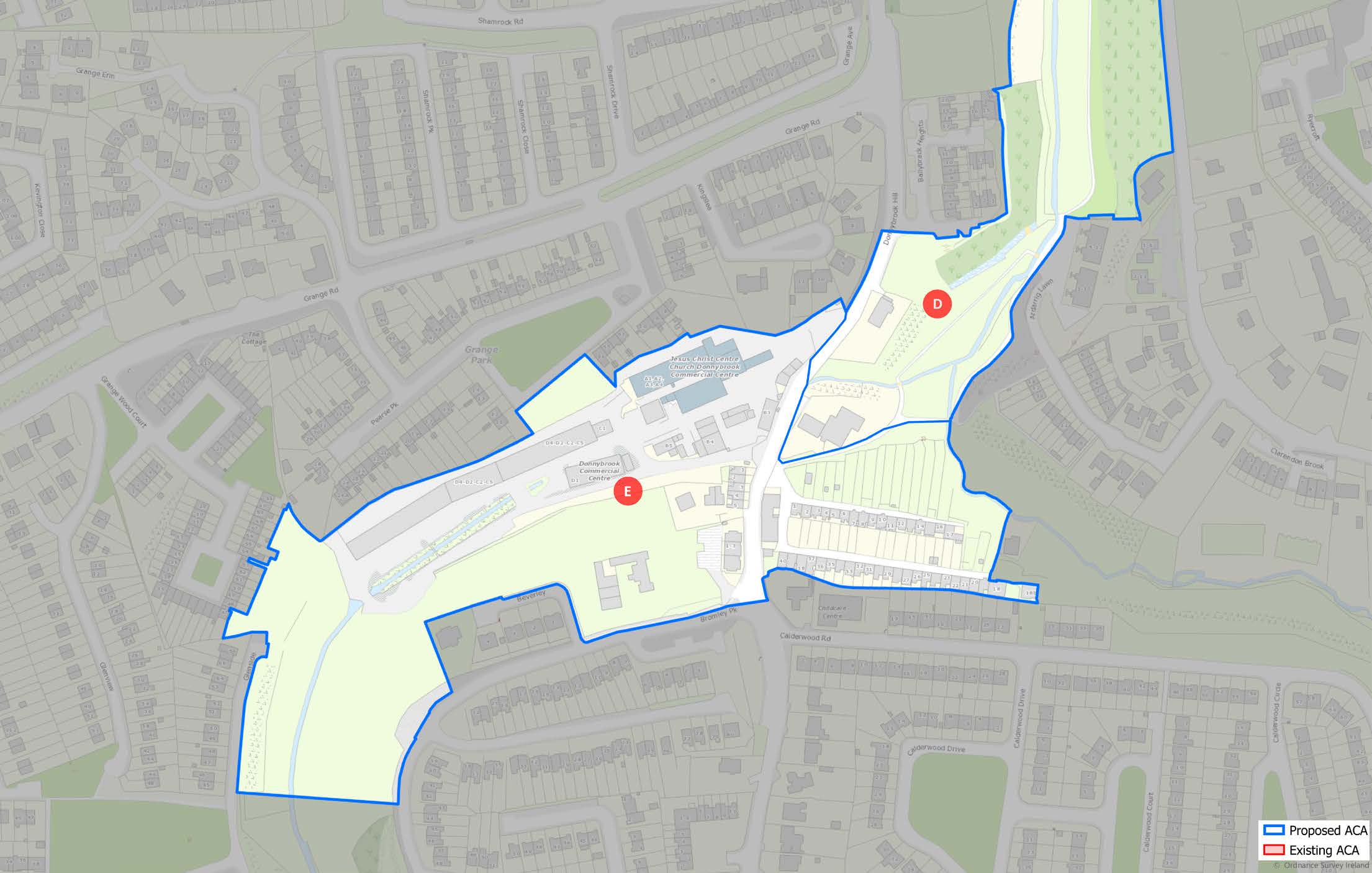
The Mangala

1.151
The Mangala is an urban woodland at the centre of the former industrial landscape associated with Douglas Flour Mills and the Donnybrook Sailcloth Factory (later the largest hemp rope works in the South of Ireland). The Douglas Stream falling into valley gave rise to the development of waterpowered industry. The housing associated with the industries remains to this day and is one of the principal constituents of the character of Douglas village and Donnybrook as they are today.

1.152
Mature woodland on the steep escarpments to the East and West, contains this quiet green oasis at the centre of the former industrial landscape created by the fast-flowing Douglas/Ballybrack Stream, before it falls away to join the Tramore River to the north.

1.153
The popularity of the area could lead to pressure for the development of better public facilities, requiring careful and informed management to avoid negative impact on the natural character and wildlife of this unlikely and quiet green area at the centre of the bustling suburban area.
(Click on Map for High Resolution Image)
ACA
Douglas-Donnybrook
Sub-Area E:
Donnybrook Mill and
Environs

1.154
Donnybrook Mills is located on a narrow valley tributary of the Douglas River. The industrial buildings run parallel with the river, while the associated residential buildings cluster to the east end of the industrial complex. Industrial activity here dates from the eighteenth century when a flax mill was first established. Subsequent expansion saw the earlier mill buildings replaced by the present extant 19th century mill and storage buildings. The ACA includes the terraces of houses built to accommodate owners and workers.

1.155
The landscape is defined by the tributary river to the Douglas River which runs through a narrow valley with a steep rise to the South. The 18th and 19th century industrial buildings of red and beige brick are arranged to run parallel with the river. This cluster of historic structures also includes the associated country house of the owner, terraced residential buildings of cut limestone and rendered, single storey cottages which were inhabited by workers. This collection of buildings is important as all strata of the historic society are represented in the group in addition to the industrial buildings themselves.
(Click on Map for High Resolution Image)

1.156
The multi-storey Mill buildings are characterised by Flemish bond red brick with beige brick window openings and quoins. Large, numerous, camberand square-headed window openings with stone sills characterise the large mill while the ancillary storage and administration buildings also of Flemish bond red brick have window and door openings highlighted with beige brick. Roofs are of natural slate with cast-iron rainwater goods.
1.157
Donnybrook House, an early 18th century residence of one of the original owners of the mill, is an modest sized country house with later early 19th century “Gothick” alterations such as the slate hung towers.
1.158
The terrace of 5 residential buildings at the lower end of Donnybrook Hill are of high quality being of snecked, coursed limestone with brick, blockand-start window, and door surrounds. Pitched natural slate roofs with rendered and red brick chimneystacks, ceramic ridge tiles and some surviving cast-iron rainwater goods. Rendered boundary walls to front and rear with gate piers and wrought-iron gates.
1.159
The two terraces of workers cottages are typified by being single storey, with red brick chimneys punctuating the property divisions on natural slate roofs and originally would have had cast iron rain goods, many of which have been replaced with PVC. The front doors are centrally placed with flanking windows with stone sills. The buildings are, and originally would have been, rendered and painted.

1.160
The requirements for space and light of modern living have given rise to insensitive additions to the industrial buildings. The domestic structures have suffered from the replacement of quality features such as sash windows and cast-iron rainwater goods with unsuitable modern plastic equivalents. The addition of large dormers and porches to the cottages has a negative impact on the rhythm and historic character of the terraces. The historic Donnybrook House is undergoing conservation work to prevent further loss of historic fabric.
1.161
The continuing use of the industrial buildings is welcome, but not all the associated interventions to facilitate modern uses has been carried out to the same standard, resulting in some loss of fabric while insensitive signage proliferates which has a negative impact on the historic character of the mills.
ACA
Sunday’s Well
(Click on Map for High Resolution Image)

1.162
Sunday’s Well is an area located on the steep south-facing slope of the north ridge of the city, overlooking the eastern side of the city centre. It can be seen as a full residential suburb with subareas clustered around a linear street running east west, located halfway up the slope and containing local village services, church, education, shops and pubs set into a mix of older and newer houses, generally orientated towards the south.
1.163
It is bounded to the south by the escarpment of the flood plain of the North Channel of the River Lee, on the north by the rear boundaries of houses on Blarney St., to the east by the older streets off Shandon St. and Blarney St. and to the west by the large-scale institutional lands of the Lee Road. It is proposed to extend the ACA sub-area A by including the section of the south-side of Sunday’s Well Road to the west of the UCC School of Music in the former St. Vincent’s seminary complex.

1.164
There are six distinct sub-areas within the ACA. The ACA combines a strong built form with an equally strong landscape character. The landscape character benefits from an “Area of High Landscape Value” designation (see Volume 1/ Chapter Policy).

1.165
The area’s buildings range from the large institutional buildings in stone and brick through larger detached houses on their own sites, semidetached and terraced houses of considerable scale to smaller houses and cottages on lanes and backstreets. Houses are typically constructed of painted plastered rubble-stone or brick walls, several with slate-hanging on exposed southern facades. Where they retain original finishes and features, they have roofs of natural stone slate, robust cast-metal rainwater gutters and downpipes and painted timber doors and windows and many good examples of iron railings and gates.
1.166
Surviving historic street furniture and paving, such as limestone steps and kerbing, iron handrails and guardrails make a significant contribution to the character of this distinctive area.

1.167
The principal street in the ACA, Sunday’s Well Road, is narrow without sufficient room for two cars to pass along all of its length. Lack of sufficient onstreet parking can be an issue for family occupation of houses, leading to pressure for the creation of offstreet parking with the resultant loss of front gardens. Intensification of vacant and under-used sites, for example in Sub-area D, is problematic because of poor access and integration of the sites with the already narrow surrounding road network.
ACA
Sunday’s Well
Sub-Area A:
Village Centre
1.168
This sub-area of architectural, historical and social significance is located on each side of Sunday’s Well Road, above the escarpment overlooking the flood plain of the River Lee. It contains mixed range of house types, from older 18th C houses which predate the expansion of the city to more regular blocks of houses laid out to take advantage of the views south interspersed with shops, pubs, a church, and other religious buildings. The development of the area in the later 19th century is associated with staff from the Queen’s College moving into the desirable newly developing suburb.

(Click on Map for High Resolution Image)
ACA
Sunday’s Well
Sub-Area B:
North East Panoramic
Terraces
1.169
This sub-area of architectural and historical significance is clustered around Sunday’s Well Avenue, the street which links Blarney St. to Sunday’s Well Road, and which was the main access from the east before the construction of Wyse’s Hill. The buildings, whether individual houses or blocks of terraces are oriented towards the south, generally having gardens on the southern side of the plots independently of whether access is from the north or south.
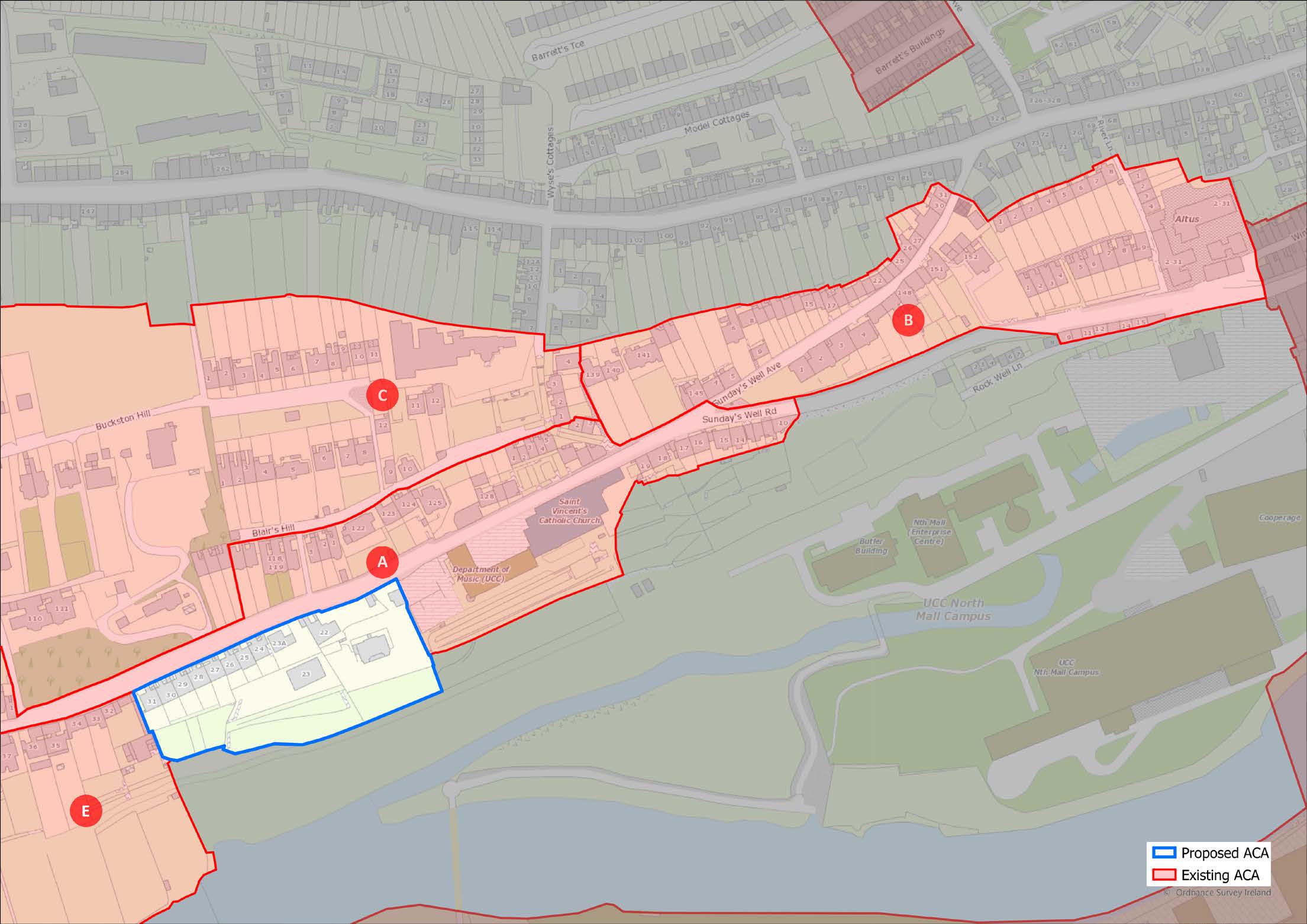
(Click on Map for High Resolution Image)
ACA
Sunday’s Well
Sub-Area C:
Buckston Hill
1.170
This sub-area of architectural and historical interest is located above Sunday’s Well Road on what was vacant land located between the rear of the building plots along Blarney St. and those along Sunday’s Well Road. The buildings, whether individual houses or blocks of terraces are oriented towards the south, generally having gardens on the southern side of the plots independently of whether access is from the north or south.
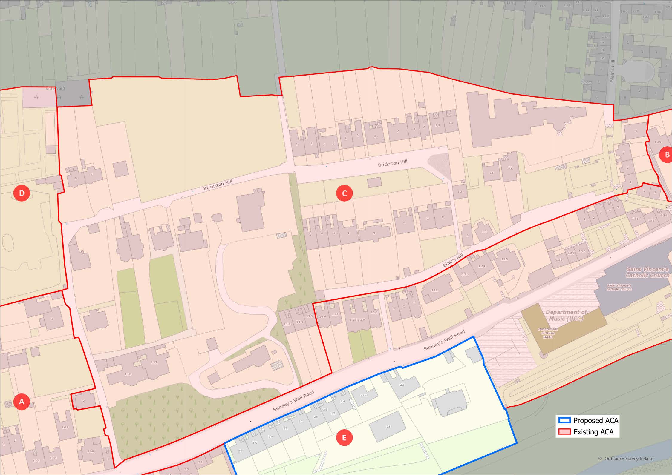
(Click on Map for High Resolution Image)
ACA
Sunday’s Well
Sub-Area D:
Former Institutional
Lands
1.171
This sub-area of architectural, historical and social interest is located above Sunday’s Well Road and to the west of the housing in Sub area C. It contains two large institutions, the former Gaol and the former Good Shepherd convent, laundry, and home - both institutions laid out on very large sites at a time when the sub-area was on the edge of the city. Neither remains in its original use, and the Good Shepherd site has been vacant for many years.

(Click on Map for High Resolution Image)
ACA
Sunday’s Well
Sub-Area E:
South Facing Gardens
1.172
This sub-area of architectural and historical interest is located to the west of Sub-area A, and is similar in character but, as it developed later and is further from the older city centre, many houses have gardens that continue to the edge of the North Channel. The area to the south of the houses is a Landscape Preservation Zone (see Volume 2: Mapped Objectives) and the residual area is an Area of High Landscape Value.
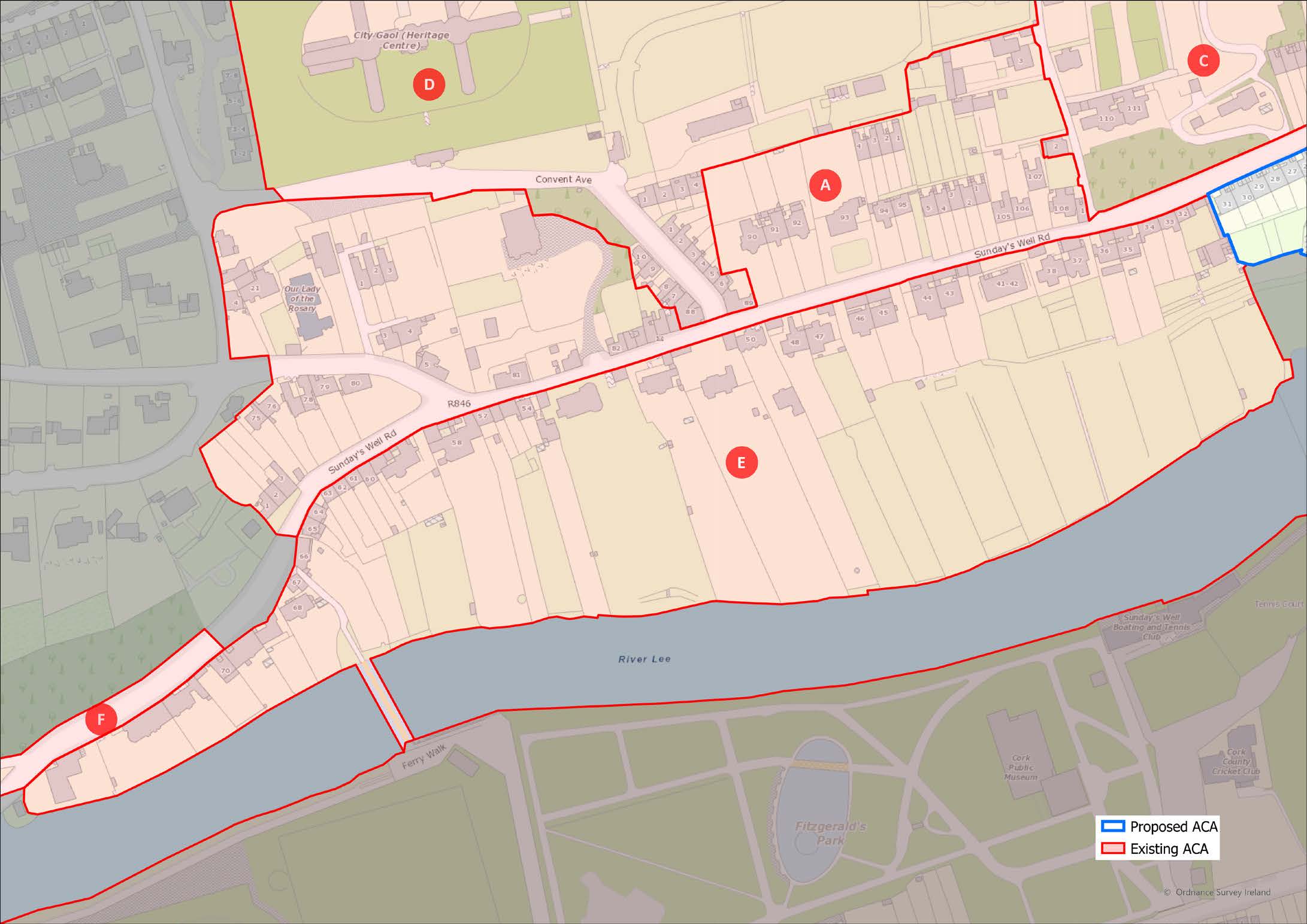
(Click on Map for High Resolution Image)
ACA
Sunday’s Well
Sub-Area F:
Western Edge
1.173
The buildings typically consist of terraced houses located at the north side of the road on sites with long front gardens, overlooking the North Channel of the River Lee.
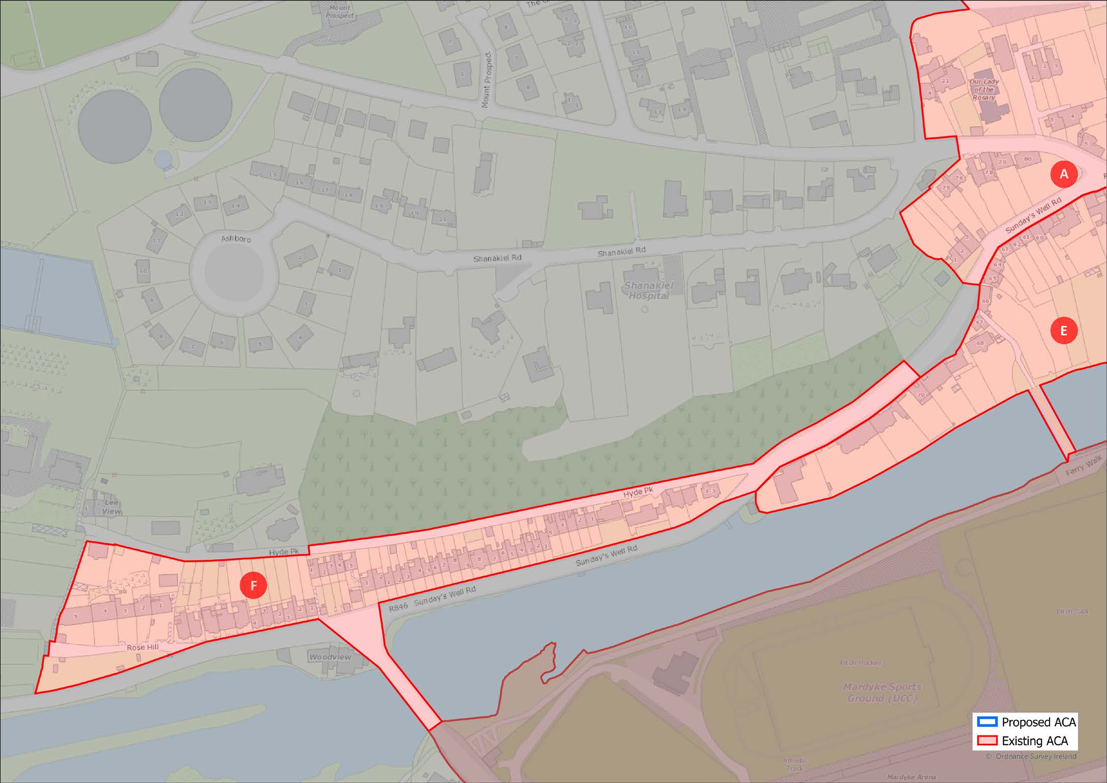
(Click on Map for High Resolution Image)
ACA
University College Cork (UCC), College Road
and Magazine Road
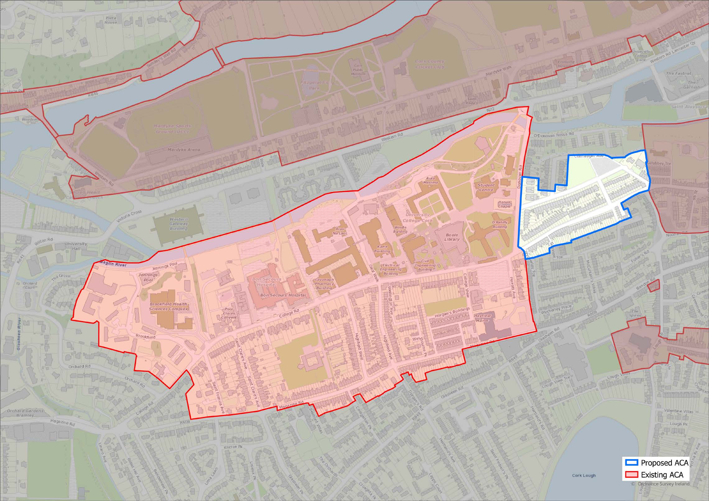
(Click on Map for High Resolution Image)

1.174
This ACA is centred on College Road which runs east west and is bound to the north by the south channel of the River Lee and to the south by Magazine Road. The area is institutional in nature, incorporating University College Cork’s main campus and ancillary buildings, and the Bon Secours hospital. It also incorporates the old County Gaol site which is now integrated into University College/ Magazine Road.
1.175
UCC opened in 1849 and incorporated the quadrangle and other early campus buildings such as the Crawford Observatory. However, the other early buildings have since been removed. Prominent dwellings, namely Áras Na Laoi and Brookfield House, which are under the ownership and occupancy of UCC were some of the first dwellings built for wealthy families in this area of Cork. The remains of the Cork County Gaol site are also integrated into the main grounds of UCC. UCC grounds contain many important trees.
1.176
The Honan Chapel was constructed much later than the initial buildings on the main campus (1915) and the Edwardian houses adjacent to the chapel were also constructed around this time (1910). The university building (geography) adjacent to these houses was constructed in 1928.
1.177
Dwellings along College Road were primarily constructed due to their proximity to UCC in the latter part of the 19th century and early part of the 20th century, followed by the construction of Horgan’s Buildings and dwellings along Magazine Road and Perrott Avenue in the 1920s. Gaol Walk was the primary access bridge to the city and was constructed in 1835. Donovan’s bridge was constructed in 1902 and acted as an additional primary access route to the city, with the UCC entrance bridge from Western Road being constructed in 1916.
1.178
The Poor Claire Colettine Monastery was developed in 1914 and the Bon Secour Hospital was also developed at this time (c.1915) adding to the existing institutional buildings in the vicinity.
1.179
It is proposed to extend the ACA to include the east end of College Road towards Gillabbey St. and Connaught Avenue.

1.180
This area is important in terms of its historical, architectural and social significance. The majority of the current street pattern, particularly College Road, formerly Gaol Road, and Magazine Road reflects the street pattern of the late 19th century. College road acts as the main thoroughfare with Magazine Road acting as the secondary thoroughfare, and the two are connected by relatively narrow roadways.
1.181
The focal point of this area was initially the County Gaol, but the university’s main campus after its opening in 1849 became the main focal point. The area contains a cluster of institutional uses and the university dictates the primary activities of the area. Gaol Walk was the primary access bridge to the city with Donovan’s bridge being constructed much later and acting as an additional primary access route to the city. The UCC entrance bridge from Western Road was constructed after this.
1.182
Ancillary to the institutional uses, the area is primarily made up of medium density short terraced two and three-storey housing, and some retail and commercial uses. The dwellings along College Road were constructed in the latter part of the 19th century and during the early 20th century, followed by the construction of Horgan’s Buildings and dwellings along Magazine Road and Perrott Avenue in 1920s. Many infill developments between College Road and Magazine Road took place in the 20th century.

1.183
The area’s building stock ranges from the 19th to 20th century but is mainly characterised by the 19th and 20th century university buildings, and 19th and 20th century short terraced two and three-storey houses which line the main thoroughfares.
1.184
The variety of buildings on the universities main campus provides a range of styles and finishes. The mid-19th century quadrangle, observatory and Windle buildings are finished in limestone, as is the early 20th century Honan Chapel. These are the standout limestone finished buildings on the university’s main campus and the remaining buildings on the main campus primarily consist of limestone, rendered, roughcast rendered or brickwork finishes.
1.185
There are several examples of 19th century dwellings along College Road which can be identified by their recess from the roadway, gable dormers, arched windows to an upper floor and many also retaining redbrick chimneys. The remaining buildings in this ACA are primarily 20th century dwellings which follow the original street pattern of College Road and Magazine Road, whilst also lining the throughways between these main thoroughfares.

1.186
The majority of the College Road thoroughfare has been upgraded which has improved the aesthetic quality of the streetscape. Other areas of the architectural conservation area would also benefit from such upgrades, particularly Magazine Road. The external condition of many dwellings in the area, commonly student accommodation, is substandard and the continued maintenance of these buildings is required.
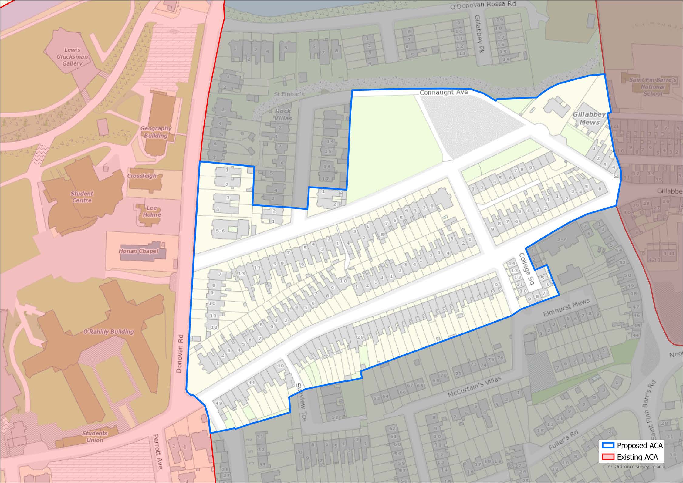
(Click on Map for High Resolution Image)
ACA
Wellington Road / St. Luke’s

1.187
It is proposed to extend the ACA by including the area to the north of Griffith College taking in the terraces of Military Hill and Military Road, and as far west as Sidneyville and Shrewsbury Villas.
1.188
The area is centred on the streets running westto- east, i.e., St. Patrick’s Place, Sydney Place, Wellington Road and St. Luke’s Place. It is bounded on the west by the rear boundaries of (but not including) the properties on St. Patrick’s Hill, on the east and south by Summerhill North (excluding the buildings on the south side of the road), on the north by the rear property boundaries of the terraces along Military Road and as far west as Shrewsbury Villas. The area also takes in the terraces to the north of St. Luke’s Cross along the lower part of Ballyhooley Road, and the bottom of Gardiner’s Hill, including Adelaide Place, as well as St. Luke’s Church and the south facing terraces immediately to the south, Clarence & Victoria Terraces.

1.189
The character of the area, of architectural and historical significance, varies as you move from St. Patrick’s Place, Sydney Place along Wellington Road and up to St Luke’s Cross. The first section from St. Patrick’s Place, Sydney Place, and the lower part of Wellington Road as far as York St. is more city-centre in character, with a mixture of uses including offices, warehouses, schools, and apartments, aimed at city-wide users. Physically, it is older, with large Georgian terraced houses entered directly from the street along the north side, and with a mixture of smaller generally later buildings facing the street along the south side.
1.190
The middle section of the area along Wellington Road is mainly domestic in character. The area is made up principally of Georgian and Victorian houses, some in single-family occupancy, some subdivided into self-contained units. Most of the houses are grouped together in formally designed terraces or in pairs. The terraces are designed to face south, although the principal access is generally, but not always, from the street side irrespective of whether the house is on the north or south side. Many of the buildings are designed to look out over and be seen from a distance from the city centre and the south side of the river. The section to the east end of the area around St. Luke’s Cross is made up of terraced buildings containing shops, public houses, a post office, and other local services in terraces of individual buildings with access directly to the street. Adjacent to the Cross on the east side, there are further blocks of grouped south-facing formally designed terraces, designed to be seen from and to look out over the immediate area and the harbour to the south.

1.191
The buildings which make up most of the area are built of brick or stone, usually rendered in lime or old cement. Where houses retain original elevational features, they have timber sliding sash windows, roofs of natural stone slate and cast-iron rainwater goods. Many houses have architecturally composed boundary walls with doorways or gates, cast-iron railings, and external steps with metal handrails. The area contains significant lengths of footpaths, with stone steps, cast iron railings and stretches of stone-kerbing. There are mature trees along the footpath on Wellington Road.

1.192
The area is undergoing change. Houses in multiple occupancy are being refurbished and returned to single-family use and into larger self-contained units. New houses are being built on former mews lanes and at the rear of large, terraced houses. Car parking for users of local services and residents is at odds with the parking by city centre commuters who park in the area and walk into the city centre.
Proposed New Architectural Conservation Areas |
| Herbert Park |
| MacCurtain Street |
| Melbourn Road Estates |
| Myrtle Hill Terrace |
| Oliver Plunkett Street |
| South Channel |
| Turner’s Cross |
ACA
Herbert Park
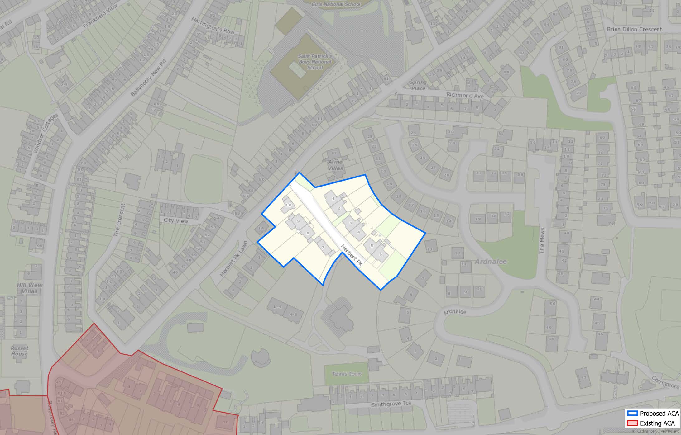
(Click on Map for High Resolution Image)

1.193
Herbert Park is a short cul-de-sac located on the east side of Gardiner’s Hill. The street was laid out in the early 20th C with three pairs of large semidetached houses on the north side of the street facing south. In the early 1930s a number of houses were built on the south side of the street. They were designed by the architect Henry Houghton Hill in a modest but sophisticated modern architectural style distinct to the original houses opposite them but sit comfortably without detracting from the original setting.

1.194
The original early 20th century pairs of houses, thought to be by the noted Cork architect Arthur Hill, are designed in an arts and crafts style characteristic of the Edwardian period. The group retain to a remarkable degree their original architectural features and are a superb example of middle-class housing of their time and place.
1.195
Though the street was originally laid out with building on the north side, a number of houses by the architect Henry Houghton Hill were constructed on the southern side, carefully conceived to not compete with or take from the setting of the larger houses opposite because of their lower level and linear architectural expression.

1.196
The original houses are built in a mix of brick, roughcast render and clay tile, with stone slate roofs and timber sash windows. Each house, though one of a pair, is symmetrically designed around a projecting canted central bay with front door at ground level and a tile-clad gable projecting from the main roof.
1.197
The houses by H. H. Hill on the south side are of more modest architectural expression but of comparable architectural quality. Also, two-storey with attic accommodation, they are roughcast with smooth plaster details, tile roofs, and with smallpane casement windows but with a modernist touch. A number of other houses have been added since which sit comfortably within the pattern set by the earlier phases of building.

1.198
The houses have been well-maintained and have generally been sympathetically upgraded but there has been some loss of original detailing on a number of houses.
ACA
MacCurtain Street
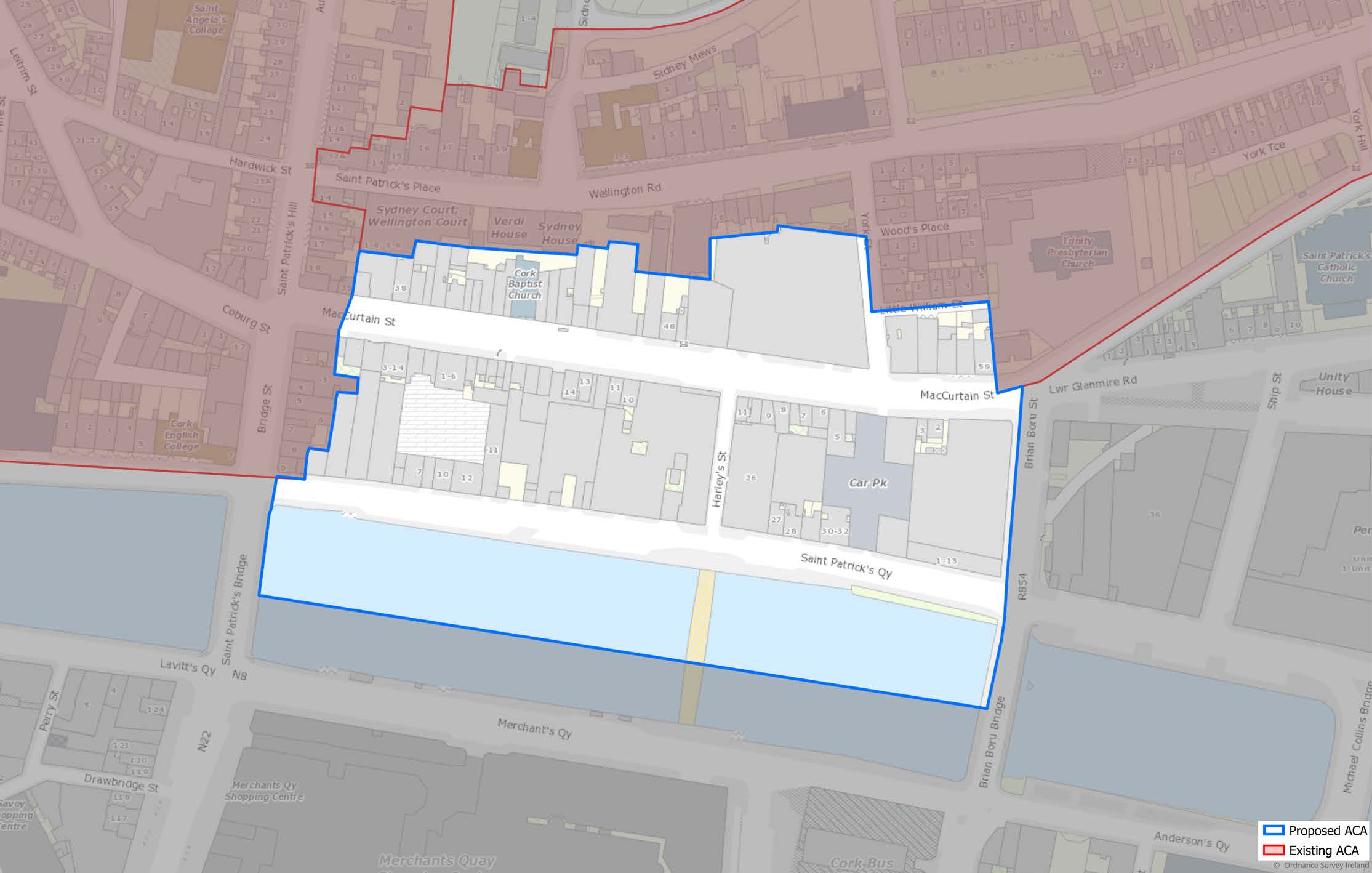
(Click on Map for High Resolution Image)

1.199
The MacCurtain Street ACA runs between Bridge Street to the west and Brian Boru Street to the east, and between the North Channel of the River Lee and the rear of the properties along MacCurtain Street where they abut the escarpment on the south side of Wellington Road.

1.200
The ACA has two principal streets of distinct and contrasting character.
1.201
Mac Curtain Street is a formal Victorian street running between Bridge Street and Brian Boru Street, with a mix of building types – ornate polychromatic stone and brick structures from the later 19th century such as Thompson House, the Metropole Hotel, and Isaac’s restaurant and hotel among them. These are interspersed with slightly earlier painted plastered terraced buildings and with a number of distinctive mid-20th C buildings along the north side, such as the curtain-walled former Thompson Swiss roll bakery and the stone faced former-CBC building.
1.202
St. Patrick’s Quay is a lower-lying south-facing quayside, with a varied streetscape lined by formershipping company offices and warehouses, many fronting enclosed yards, and covered areas behind; the informal nature of the former maritime quayside allowing for the full extent of the back of house areas of the Everyman theatre and the rear of the Metropole Hotel to be clearly seen. The limestone quayside retains steps, bollards, sections of older iron railings and wharves, evidence of its importance in the maritime history of Cork.

1.203
In MacCurtain Street contains a mix of interesting and impressive late-Victorian polychromatic buildings in red sandstone, silver Cork limestone and brickwork, along with more modest narrow frontage painted plastered structures with timber sash windows, stone slate roofs and cast metal rainwater goods. There are a number of notable 20th C structures along the north side of the street in stone, aluminium curtain walling which contribute to the eclectic and distinctive character of the street.
1.204
The buildings along St. Patrick’s Quay also date from the 19th century but are of a more modest, less flamboyant character – former shipping offices with warehouses, the informal rear sections of larger buildings which front MacCurtain Street, generally built with plastered rubble stone or brick walls, with timber windows, stone slate roofs and cast metal rainwater goods.

1.205
The new Mary Elmes Bridge has greatly improved the link between this ‘Victorian Quarter’ and the city centre island and will lead to an intensification of development of underused sites. It is desirable that the existing Victorian and maritime structures are retained as part of the regeneration of the quarter.
The building of bridges to the east in the 20th C cut the quayside from the shipping, and the lack of use has led to the decay of maritime quayside infrastructure. It would be desirable to encourage greater use of the river to take advantage both of the existing infrastructure and of the south-facing aspect of the quayside.
ACA
Melbourn Road Estates
incl. Allendale Avenue, Allendale Drive, Fremont Drive, Woburn
Avenue, Woburn Drive, Nos 20-29 Melbourn Avenue (inclusive),
11-20 Beverly Drive (inclusive), and Melbourn Road (Nos: 15, 17, 19, 21,
23, 25, 27, 29, 28, 30, 31, 32, 33, 34, 35, 36, 37, 38, 39, 40, 42, 44, 46, 48)
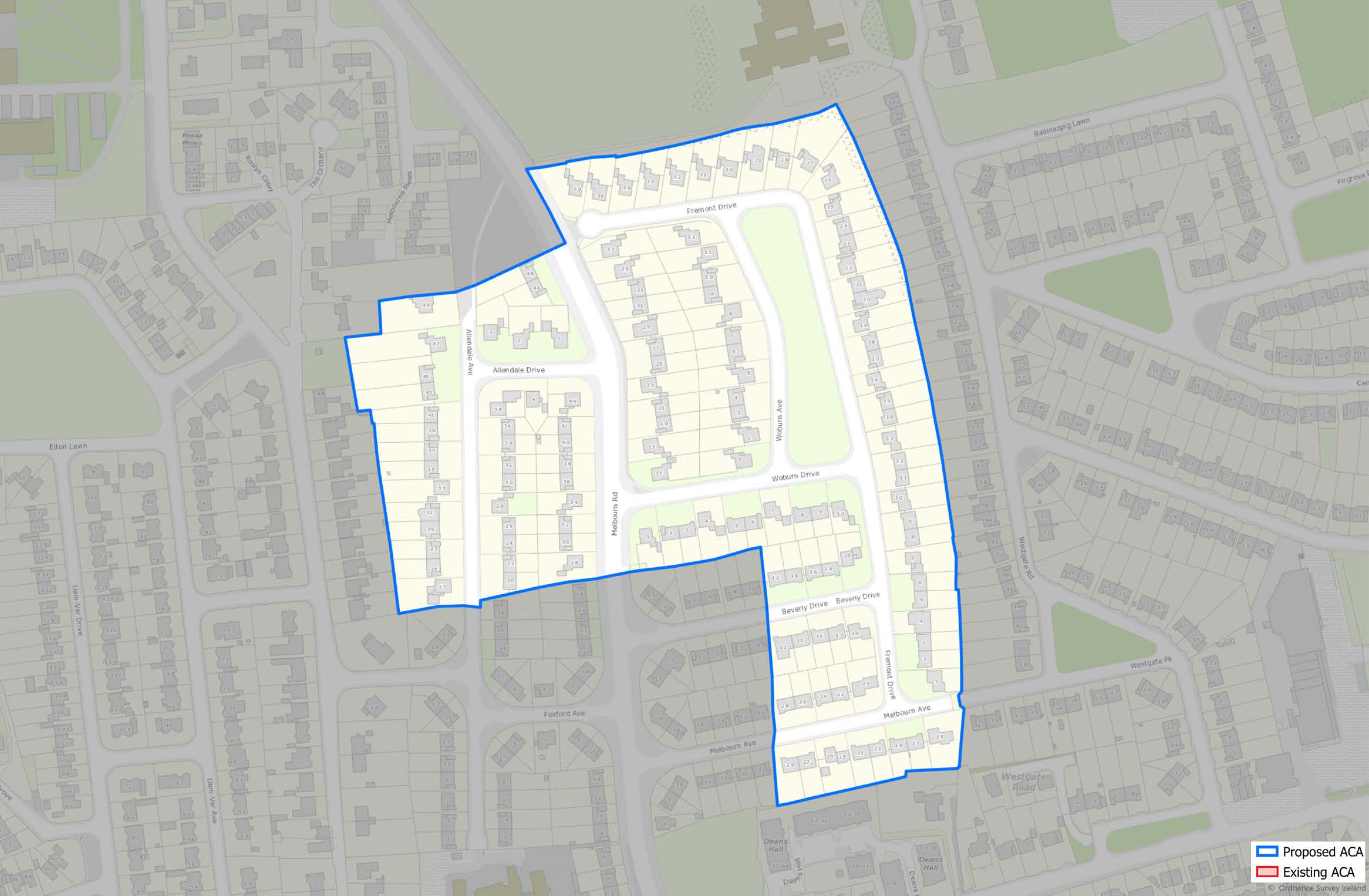
(Click on Map for High Resolution Image)

1.206
This ACA is focussed on the central section of Melbourn Avenue. A suburb developed during the late 1960s and early 1970s. Over time, education buildings such CIT (built 1977), Bishopstown Community School (built 1979), and Scoil an Sprioraid Naoimh Primary School (opened 1964), were built around Melbourn Road. The estate was originally built as a cul de sac from Curraheen Road. In 1979 this was opened onto Rossa Avenue to connect Curraheen Road and the Model Farm Road.
1.207
An estate of 132 houses, designed by Cork architect, Denis Higgins (d.2001) based on a new style of open-plan, sub-urban design, Higgins had spent 4 years in Boston, America during the 1960s (Woburn is a city 9 miles north of Boston. Beverley is also in Massachusetts). He was also the designer of Janeville Blackrock Road. This contrasted with the earlier development of 1965 which was not open plan (Frank Murphy Architects) on what was then Hawkes Estate by builders Cotters of Douglas.

1.208
This is a clearly identifiable modernist, sub-urban landscape characterised by the lack of boundary walls between the properties giving an open, spacious character, quite unique in the city. The houses are a mix of semi-detached and detached homes, surrounded by lawn laid out in a staggered pattern to allow an element of privacy between properties. The area is also defined by wellestablished mature trees planted on the corners of each property either singularly or often in groups of threes for smaller species.

1.209
The houses are characterised by a mid-century modernist design with horizontal windows, overhanging eaves, brick and cedar cladding, gable fronted (for detached dwellings), with pebbledash render to the sides and rear.

1.210
Currently there is an open-plan character to this sub-urban landscape, however increasingly residents are defining property boundaries through the use of fencing or hedging. This will negatively affect the overall character and original design vision for the estate. New fences appear to be generally along the Melbourn Avenue, which is subject to heavy traffic, often over the speed limit, with 2 road traffic fatalities in the recent past. The erection of boundary fences is not generally subject to planning permission requirements as they are at the side or rear of the dwellings however, they do have a negative impact on the open-plan character of the estate. Improved speed limiting measures (electric signs, speed bumps etc) could reduce traffic speed and as a result may remove the desire for boundary fences. The layout and elevations of the dwellings are part of an overall modernist architectural scheme intrinsic to the character of the estate.
ACA
Myrtle Hill Terrace
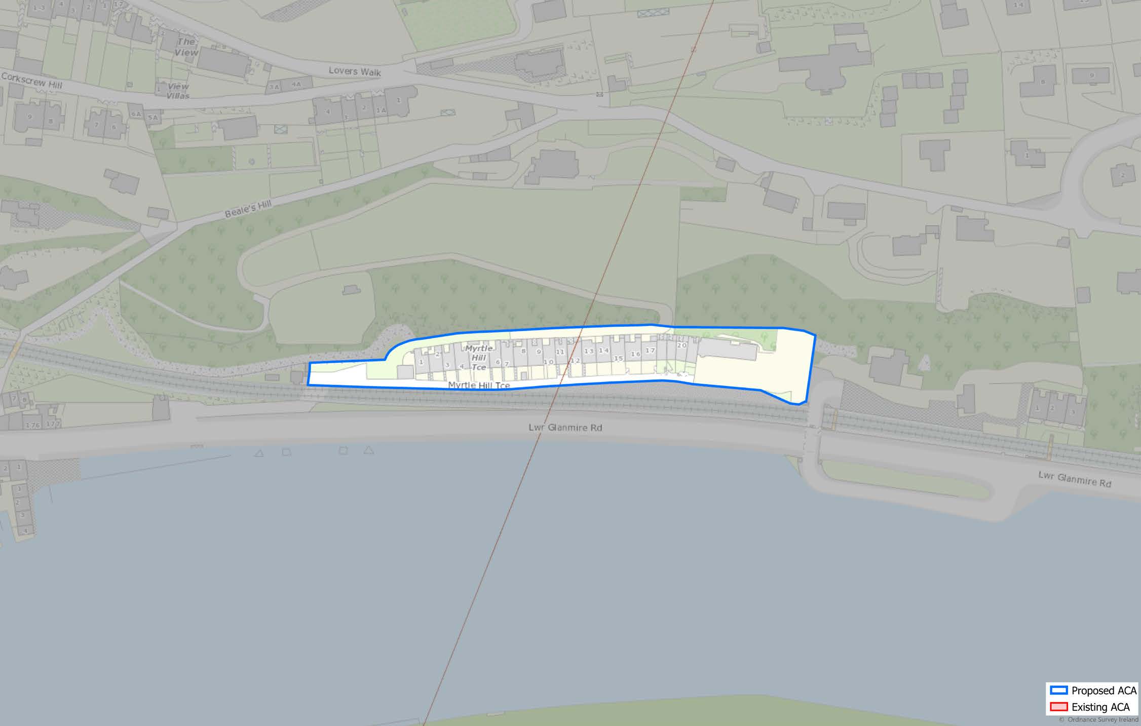
(Click on Map for High Resolution Image)

1.211
The Myrtle Hill Terrace Architectural Conservation Area is located to the north of, and overlooking, the River Lee, and directly opposite Marina Park, and to the South of a private laneway to Myrtle Hill House. The site is bounded by private road, a public road (Lower Glanmire Road) and the railway line. The houses have developed in an East to West fashion, with the older houses located in Eastern section of the terrace, on land to the south of the Myrtle Hill private entrance which still contains a set of limestone pillars and some partially surviving cast iron railings. The houses have been cut off from the public road with the development of the railway and are now accessed over a level crossing.

1.212
The area is of architectural and historical significance and comprises of some protected and non-protected structures, while the houses are overwhelmingly residential in character. Myrtle Hill Terrace is served by a single road which contains two and half and three storey terraced house which are typically single occupancy or sub divided units. These are typically set behind a wall and iron railings. However, some of the original walls, gates and railings have been removed to create space for cars or have been replaced with modern equivalents. Opposite the houses is a stone boundary wall that prevents access to the railway line. All of the houses are designed to face south, and access is from the road side of the house. The terrace has been designed to look out over the river, taking advantage of the views.

1.213
The buildings date back from the 19th Century and are constructed using painted rendered masonry. Many of the buildings retain their original elevation features and curtilage, including string course, sliding sash windows, timber painted doors and door cases with fanlights, columns, window architraves, stone steps, stone slates and original gates and railings.

1.214
Many buildings have been refurbished in recent years. Some buildings have also been subdivided into multiple occupancy dwellings. Some buildings have not been maintained in a manner appropriate to their architectural character. While many of these houses have been refurbished to a high level, some have not, and standards of workmanship and detail can be inconsistent. The need to provide car parking in particular has led to car parking, and the loss of original cast and wrought iron gates and walls.
ACA
Oliver Plunkett Street

(Click on Map for High Resolution Image)

1.215
This area is centred along the east-west axis of Oliver Plunkett Street. It is bounded on the east by Parnell Place and Grand Parade on the west. The Street is also bound by St. Patrick’s Street/Maylor Street to the north, and South Mall to the south.

1.216
In addition to its architectural significance, street is home to the site of Cork’s New Town, laid out in 1715. The Street, originally named after King George, reflects a new form of street design, uniform and straight, with smaller side streets running in a north-south direction. The street has a similar design to the one seen in Edinburgh’s New Town. The centre of the street, around the area of the General Post Office, has rounded corners which create a central space adding to the street’s civic importance.
1.217
Oliver Plunkett Street was a street dedicated to trade and still serves this purpose today. It is still at the heart of the city’s commercial sector over 200 years after the street was originally laid out in the New Town format.

1.218
The street mainly contains buildings with 2-3 bays, however there are some exceptions, such as Keane’s Jewellers, while the building height tends to be between 3 and 5 stories. The ground floor uses for the street tend toward commercial uses, with office and residential spaces on the upper floors. The external elevations are generally painted plaster, and the buildings contains some notable features, such as sliding timber sash windows, various forms of window and door architraves, some cornices, and door cases with fanlights.
1.219
There are a number of large-scale buildings located along the street and these provide a leisure and shopping facility, as well providing services. The street also contains a number of institutional buildings; some notable examples are the Unitarian church, which is still in use today, the GPO, Keane’s Jewellers, Winthrop Arcade and Minahan’s Chemist/Hi-B.

1.220
The street does suffer from some issues such as empty or underutilised upper floors. Unused office space and storage have takenover from what was once a residential use. There are some abandoned buildings along the street as well as some derelict sites/poor state of repair also. The fact that the street is in an inner-city location means there is demand for large floor space and for buildings to be combined to increase floor space sizes.
ACA
South Channel
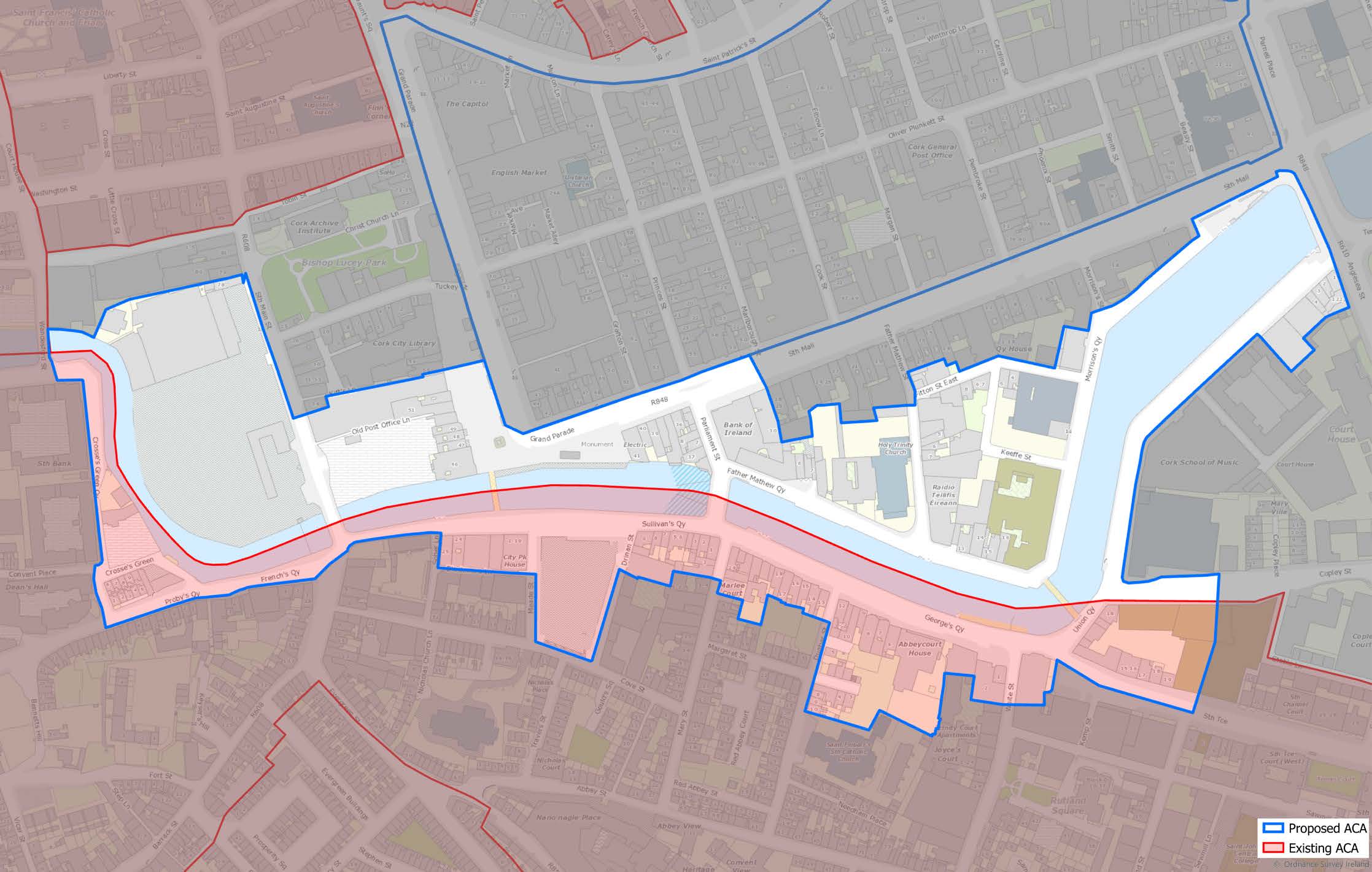
(Click on Map for High Resolution Image)

1.221
The South Channel of the River Lee forms the southern boundary of the central island (historic core) of the city. It is important to remember that the city was shaped around the two channels and so the South Channel is an integral feature of shape of this part of the city and indeed its history. The 1.5km stretch of river forming the ACA begins at Clarkes Bridge to the West and ends at Kennedy Quay to the East (Fig. 1). It has a collection of quays, slips, steps, weirs, and bridges of various ages along the river channel.
1.222
Infrastructure along the river is of significant importance to the urban landscape of this part of the city, iron railings, carved railing piers, limestone steps, slips, mooring rings and immense stretches of wooden quay fenders communicate the connection to the industrial and maritime history of 19th and 20th Century Cork. The fenders from Parliament bridge Albert Quay make up what appears to be the longest stretch of historic quay fenders in Ireland and the UK.
1.223
There are 68 structures in total along the Channel which are listed on the NIAH which form the backdrop to the South River Channel pACA. A defining aspect of the character of this area is the relationship between the river and the buildings built on the riverbanks, these buildings were commercial, warehouses whose form and purpose were directly related to the river and the sea. The established ACA of the South Parish bolsters stretches of this proposed ACA (Fig. 3) which is a testament to the quality of the urban landscape in this area of the city.

1.224
There are a number of infrastructural and architectural elements that contribute to the overall character and special interest of the River Lee South Channel. These include but are not limited to, weirs, different types of moorings, limestone walls, railings, piers, steps, slips and bridges.
1.225
Ashlar masonry of Cork limestone quay walls have significant civil engineering value and represent the emergence of the modern Cork city out of the intricate swampy channels of what was once estuarine marshland. Historic bridges in addition to being focal points and historic access routes add significantly to the historic character of the area.

1.226
The quay walls tell the story of how the city developed over the centuries. A vast number of architecturally significant structures are located along the quaysides of the river where they overlook, interact, and utilise the river. The materials used, local limestone in particular, are of a quality and mass which is irreplaceable today. The craftsmanship that went into carving historic fabric for the piers, bridges and quay walls would be extremely difficult/ prohibitive to replace if lost.

1.227
The course of the river Lee through the modern city centre has been an elaborate exercise in engineering from the earliest marsh land existence of settlement here. The bridges and their locations date from the 1700s, in particular Clarkes Bridge, which was once the widest bridge on the island of Ireland. The widening and deepening of the channels made significant improvement to ‘scourge’ of flooding in early 19th Century Cork as described by Windele (1839) where: “formerly the City was subject to frequent inundations, causing much damage, and it was no unusual thing to see boats plying through the open streets. These visitations have of late years been scarcely perceived, owing to the greater capacity of the channels; and it may be presumed that plying by boats over the paved ways of the City, will not occur again”.
1.228
The shape of the channel itself, with the almost right angle of the bend at Trinity Bridge and again at Crosses Green were informed by older tidal channels and can be traced in shape over the centuries through the old maps of the city. Weirs dating back many centuries, creating pools used by the tanning and brewing industries, are also evident along this section of the river adding interest at low tide.

1.229
The river itself is the foundation of Cork’s success as a merchant city and its history from first settlement is well documented in maps where the form of the river can be traced through changes to its final path. The provisions trade during the late eighteenth century was internationally significant and made possible by the large harbour and navigable harbour and navigable river Lee. The timber fenders fitted to the quay walls are of great historical significance, the scale of which is not seen anywhere else in the UK and Ireland. Timbers along the South Channel have been identified as from the same time where a large-scale fender plan was initiated between 1984-1986 to protect the quay walls.

1.230
The area enclosed in the pACA is of core cultural and social significance to the identity of Cork City. The quays have been the site of import and export of fruits of Corks industrial and agricultural labours, such as the world-renowned butter and provisions trade. Life along the quays is part of the everyday experience of the residents of the city today as it was in the past centuries. Historic quayside infrastructure such as the fenders, steps, slipways, and railings are a direct link to the Quays and the river channel in its former shipping existence. While somewhat under-utilised at present, these existing features have the potential to be reinstated as key aspects to river usage in Cork City’s future.

1.231
The The river is both an urban and natural landscape and is therefore subject to many agents of change such as weather, climate change, pollution, development, and neglect. Changes in use of the river have in some areas resulted in poor maintenance or abandoned areas.
1.232
It is accepted that significant change will occur. Modern Development is part of the evolving character of the city and is welcomed within ACAs provided that the proposed designs are cognisant of and has regard for the relationship between the river and the building stock, forms, patterns, and heritage associated with it. Current and future plans for the riverbanks of the proposed ACA, have and will take account of the extant historic features. The Morrisons Island Public Realm and Flood Protection Project will have no detrimental impact on the ACA and will in fact adhere to and compliment the ACA objectives.
1.233
Natural decay of the fender network is a significant issue with surveys reporting the condition of the 244 fenders on this section of the river as poor to very poor or collapsed in places. Options to conserve, control decay or replace sections of the structures are being considered by the Conservation unit of Cork City Council.
1.234
Traffic on the quays detracts from the feel and use of the river channel, particularly along Morrison’s Island through noise and car parking obstruction.
ACA
Turner’s Cross
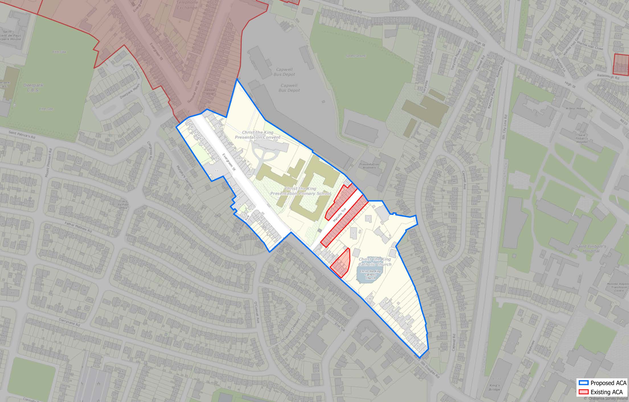
(Click on Map for High Resolution Image)

1.235
Evergreen Street and Turners Cross are located in a southern suburb on the outskirts of the Georgian era Cork City on a relatively flat, raised area of ground overlooking the city. The Western side of the street is raised with limestone kerbed steps leading up from the road.

1.236
Turners Cross ACA is essentially a long historic street lined with predominantly single storey, 3 bay, vernacular cottages which originally had long rear gardens. This area was the once rural market garden for the historic city as can be seen in the First Edition OS map. The area also includes the religious/ educational complex of the Bunscoil Chriost Rí in addition to the highly significant Modernist, Church of Christ the King.

1.237
The building stock is characterised by early 19th century vernacular, rendered terraced dwellings. Typically 3 bay with central door opening onto the street. Pitched natural slate roofs, cast iron downpipes, rendered elevations with chimneys punctuating the plot divisions. Many of these structures would have originally been thatched and there is a possibility of one structure remaining which is potentially thatched under a corrugated iron roof.

1.238
The Currently some of the historic character to the street has been lost through inappropriate alterations (alterations to roof, insertion of modern shop fronts etc) or demolition and replacement. A critical number of historic buildings remain, however. Upgrading/ renovating the structures has meant loss of original windows and doors, cast iron rainwater goods being replaced with plastic and in some instances the replacement of natural slate roofs and the removal of the chimneys which interrupts the plot rhythm. Intensive traffic detracts from the historic character of the street and creates noise and pollution which makes the area unpleasant for residents.

1.239
The policy framework for Cork City’s View Management Framework of views and prospects of special amenity value is set out in Volume 1: Chapter 6: Green and Blue Infrastructure, Open Space and Biodiversity. Tables 1-4 (below) should be read in conjunction with maps that illustrate the views and locations identified set out in Volume 2: Mapped Objectives.