See attached document for submision.
Address redacted.
4. Shaping the Structure of the City
Dúnta26 Mei, 2020, 00:00 - 21 Lún, 2020, 16:00
4.1. Introduction
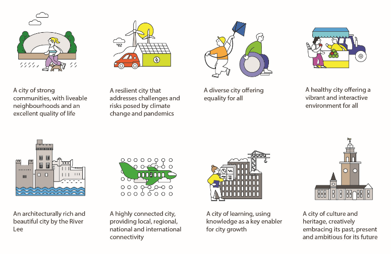
The Cork City Development Plan will provide the framework for shaping the future structure of the city for 2022 - 2028. To do this, the plan will need to be driven by a very clear set of principles, including those illustrated below.

4.2. The Core Strategy
The Core Strategy is the heart of the plan, setting out a framework for spatial growth of the city. It will be based on population, housing and job targets and other guiding policies set out in higher level planning documents, like the National Planning Framework (NPF) and the Regional Spatial and Economic Strategy (RSES). The delivery of compact growth that aligns with national and regional planning policy, alongside sustainable mobility and climate resilience will be key components of the next Core Strategy for Cork City.
Growth Targets for Cork City to 2031 and 20401

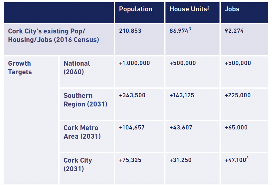
The strategy will set out key locations for future developments that provide the right mix of uses for an area, including housing, employment, community, amenities, education, health and social services, cultural facilities, sports and recreation facilities and other infrastructure. It also seeks to ensure that the right amount of land is zoned, serviced and available in the right locations so that homes, community services, places of employment and other supporting uses are provided at the right scale and balance, in line with the carrying capacity of the local environment.
The successful delivery of the next Core Strategy will also be heavily dependent on other factors including critical investment in key infrastructure and services and the collective ambitions and abilities of the public, private and community sectors. A wide range of government departments state and local agencies, community groups and bodies and other stakeholders will need to come together to inform, embrace and implement the next Core Strategy.
4.3. The Current Structure of Cork City
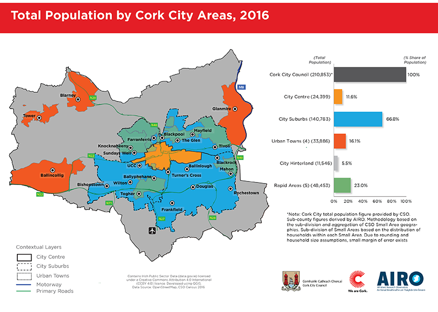
The current structure of Cork City provides the urban and social fabric within which the present city functions. It is also the starting point from where the future city will grow. Cork City’s characteristics and form are key determinants for future growth and can be better understood by dividing the city into the following five areas, which are illustrated in the map below:
- City Centre: The City Centre is a collection of sub areas including; the City Centre island, McCurtain Street, Shandon, South Parish and North and South City Docks.
- City Suburbs: The City Suburbs is a collection of city neighbourhoods, including; Ballinlough, Turners Cross, Sundays Well, Bishopstown, Douglas and also includes Tivoli Docks.
- RAPID Areas: The RAPID Areas 1 are; Fairhill/ Gurranabraher/Farranree, Blackpool/The Glen/Mayfield, Knocknaheeney/Holyhill/Churchfield, Mahon and Togher/ Ballyphehane.
- Urban Towns: The Urban Towns within the city consist of the those with a population of 2,000+ persons, being; Ballincollig (18,159), Glanmire (9,903), Tower (3,274) and Blarney (2,550)
- City Hinterland: The City Hinterland is the remainder of the city, including smaller settlements like Kerry Pike and White’s Cross. It contains a mix of uses, including agricultural and industrial, that are adjacent to the city.
The population living in these five areas of the city varies considerably. The City Centre accounts for nearly 12% of the city’s overall population with significant capacity for future growth, most notably in City Docks. The surrounding City Suburbs are a dense collection of neighbourhoods collectively accounting for two-thirds of Cork City’s population total. The five RAPID areas all form part of the City Suburbs, and together account for nearly a quarter of the city’s total population. The four Urban Towns account for 16% of the city’s population, with Ballincollig accounting for over half of this. The City Hinterland is the largest area by land mass but accounts for only 5% of the overall population living in Cork City.
4.4. Delivering Sustainable City Growth through Liveable Neighbourhoods
City neighbourhoods are the building blocks of all cities, being a combination of local places, spaces and homes that collectively form and inform the connection between a city and its people. ‘Liveable City Neighbourhoods’ are places where these elements combine to enable positive social connections. They are based on a combination of factors that have repeatedly proven to create a happy place to live. Some examples of these factors include;
- An attractive built environment at a human scale;
- A child friendly and age friendly environment with a mix of household types;
- A safe neighbourhood enabling access for all;
- A healthy neighbourhood with direct access to high quality parks and public spaces; and
- A well-connected neighbourhood with easy access to good public transport and active travel.
A key objective of the Cork City Development Plan is to ensure that each neighbourhood, which collectively form Cork City, are attractive places to live, work and interact. The recent 19% increase in population living in Cork City Centre, being four times the growth rate for the overall city 2, reflects the demand for living in urban neighbourhoods that are highly accessible to employment, culture, recreation and other city attractions and events. The planning and development of ‘Liveable City Neighbourhoods’ will be a primary ingredient in achieving a more sustainable and resilient Cork City.

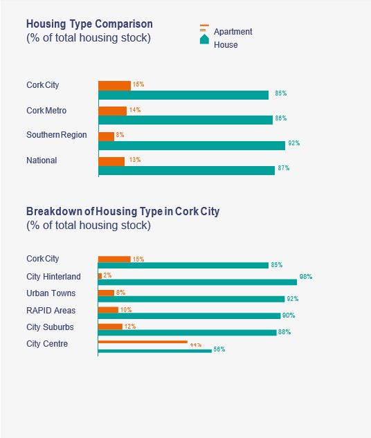
Housing is an essential element in creating ‘Liveable City Neighbourhoods’. Cork City currently has a diverse range of housing types and tenures that differ greatly by location across the city. Understanding the nature and mix of households3 that form these neighbourhoods is an important starting point in planning for the future development of more liveable neighbourhoods.
As the 2016 census shows detached, semi-detached or terraced housing collectively account for the large majority of Cork City’s housing stock (85%), closely matching the national (87%) and Cork Metropolitan Area (86%) rates. Apartments or flats accounted account for a low proportion of Cork< City’s total housing stock (15%). However a breakdown of house types within the city shows that flats and apartments make up close to half the housing stock in the City Centre the City Suburbs (12%), the Urban Towns (8%) and the City Hinterland (2%).In terms of housing tenure, owner occupied housing accounts for the majority of the housing stock in Cork City (58%), being a lower rate than that for the Cork Metropolitan Area (64%), the Southern Region (72%) and the national average (69%). One in four of Cork City’s housing stock is private rental (24%), being a higher rate than in Cork Metropolitan Area (23%), the Southern Region (17%) and the national average (17%). Social housing in Cork City accounts for 14% of the total housing stock, a higher rate than in Cor Metropolitan Area (13%), the Southern Region (11%) and the national average (11%).

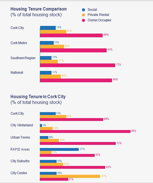
The housing tenure within Cork City differs greatly by location. The City Centre is largely made up of private rental (57%). Nearly two thirds of the housing stock in the City Suburbs are owner occupied (62%). The RAPID Areas are predominately made up of owner occupied housing (52%) and social< housing (37%). The Urban Towns and the City Hinterland both have high levels of owner occupied housing (72% and 86% respectively) and low levels of social housing (8% and 2% respectively)
4.5. The City Capacity Study – Challenges & Opportunities
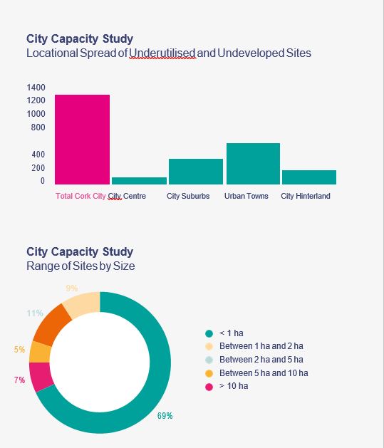
Cork City Council is currently undertaking a City Capacity Study 4 to help identify parcels of lands currently zoned, both within the built-up area and ‘greenfield’ land, that have development potential. To date, this study has identified over 1,200 Ha. of zoned lands throughout the city which are considered underutilised or undeveloped. In addition to these lands, further sites have been identified which have development potential, but the delivery timeframe is difficult to ascertain given the nature of existing uses (e.g. low order industrial parks, older institutional uses, etc.).

Much of the land identified is serviced or serviceable and developable in the short and medium term, including many infill sites and brownfield sites in the built-up area. Other lands require servicing upgrades and the next step in the City Capacity Study will be to complete the assessment of infrastructural and other constraints to gain a more comprehensive understanding of both the viability and potential time constraints in delivering future development on these sites.
The study’s findings show that Cork City has considerable land capacity to deliver the housing and employment targets set out in both the Southern RSES (up to 2031) and the NPF (up to 2040), during the next City Development Plan period and beyond 5. Investment in infrastructure will be critical in realising these targets, as will an integrated planning approach involving multi-stakeholder engagement, from national to local level.
The sites identified in the study to date are spread across the city. Collectively the four urban towns of Ballincollig, Glanmire, Blarney and Tower have the largest total area of underutilised and undeveloped land identified. However, the higher density future developments planned for in strategically important brownfield sites identified in the City Centre, including City Docks 6, will result in the delivery of much higher yields of residential units and employment floorspace within these central and highly serviced areas. Regenerating brownfield lands identified in the City Suburbs, including Tivoli Docks 7, will further help to realise the objective of more compact urban growth. A number of zoned expansion areas are also identified within the City Hinterland, being located alongside serviced and accessible locations.
There is a wide range of site sizes identified in the City Capacity Study to date. The majority are under 1 Ha. in size,< with this category accounting for over two thirds of the overall total. Smaller sites are predominately located in the City Centre and City Suburbs. Over 12% of sites identified to date are 5 ha. or greater, with 7% being over 10 ha. Most large sites are located in the Urban Towns and the City Hinterland, apart from the strategically important regeneration areas of City Docks and Tivoli Docks.
The City Capacity Study will provide an additional evidence base to inform the delivery of the new Core Strategy. This work can also be integrated into Cork City Council’s Active Land Management processes, helping to implement the Core Strategy. In doing this, Cork City Council is seeking to embrace new ways of actively progressing the ambitious growth targets, thereby enhancing Cork City’s role as the heart of both the Cork Metropolitan Area and the Southern Region.
4.6. Shaping the Structure of the City
The City Capacity Study and the Core Strategy will directly inform the wider land use strategy to be delivered within the plan, helping to deliver more ‘Liveable City Neighbourhoods’, both within the plan period (2028) and beyond (up to 2040). In doing this, the plan needs to reconsider the structure of the city and how best to build on the pattern of existing neighbourhoods and communities. The plan will aim to enhance their ability to act as ‘Liveable City Neighbourhoods’ through the delivery of mixed-use developments that are appropriate to their location in terms of type, scale, form and density. The plan will also need to fully consider how best to allocate ambitious population growth targets, based on the existing spread of population across the city.
The findings from the City Capacity Study show the wide range of brownfield infill and regeneration opportunities in Cork City, as well as some opportunities for phased greenfield development in sustainable locations. The plan will consider appropriate land use policies, objectives and actions to help regenerate and develop these sites, including:
• Delivering regeneration of sites of national strategic importance (e.g. City Docklands and Tivoli Docklands
- Regenerating underutilised sites (e.g. vacant and underutilised industrial/ institutional lands)
- Intensifying uses within existing City Neighbourhoods (e.g. Blackpool, Douglas and Mahon
- Expanding and consolidating growth within the four Urba Towns (Ballincollig, Glanmire, Blarney and Tower)
- Reinforcing well serviced urban areas through appropriately scaled and located urban expansion (e.g. Ballyvolane Urban Expansion Area).
In doing this, the plan will require new thinking. Cork Docklands (City Docks and Tivoli Docks) comprise a nationally significant urban regeneration and development opportunity that is key to the future of Cork City and Metropolitan Area, as well as to the realisation of the NPF. The development of the Cork Docklands is therefore inextricably linked t Ireland’s success and to the development of Cork City and its ability to achieve the ambitious growth targets set out for it in the NPF, as well as aiding Cork to become a city of< international significance by virtue of its scale and quality. Cork Docklands is key to delivering the proposed tram (LRT) system for Cork (set out in CMATS 2020), will be a strategi employment and residential location for Cork City, as well asreducing Cork’s carbon impact. Cork City aims for the Cork Docklands to achieve the implementation of innovative design and development responses to the environmental, housing, transport and placemaking challenges facing Irish cities. This ambition will require Cork City Council to work collaboratively with all of its partners, including the Government of Ireland, to frame development strategies and progress the delivery of projects that will be of a quality that Cork can be proud of, including the provision of enabling infrastructure and the provision of new public spaces to benefit the wider city.
Other strategically important brownfield sites will be identified and planned for to help achieve targets for compact growth and sustainable mobility. City Neighbourhoods and Urban Towns with capacity for increased compact growth will be identified. Innovative polices will be needed that focus on city regeneration that increase densities while respecting the city form. The significant potential that exists in bringing vacant upper floors back into use must be prioritised, most notably within the City Centre Island. Serviceable expansion areas within the city that can be accessed by sustainable mobility will also need to be considered for strategically phased development.
4.7. Key Questions
- How do we make our city more compact to avoid undesirable sprawl and increase the delivery of walkable city neighbourhoods and urban towns that are highly accessible by public transport?
- How do we make the most of lands that are underutilised and undeveloped in the city centre, city suburbs and the urban towns, while retaining the character and environmental importance of the city’s hinterland?
- How do we ensure the most effective use of land, infrastructure and resources, while balancing the need to retain the character, landscape, urban form and environmental qualities of Cork City?
- Do you think there are specific locations within the city that should be strategically identified for development to achieve balanced sustainable growth, if so, where and how?
- How do we achieve the regeneration of City Docks and Tivoli Docks to enable the sustainable growth for Cork City, Cork Metropolitan Area and the Southern Region?
- 1- Revitalising Areas through Planning, Investment and Development (RAPID) works with communities across Cork City focusing on areas designated as disadvantaged.
- 2- The population of Cork City Centre increased by 19.2% from 2011-2016 versus a 5.4% increase in the overall city
- 3-
- 4- The City Capacity Study is assessing lands with capacity for future development, consolidation, intensification, etc. and covers a range of sites including brownfield, underutilised industrial, infill and others. As the study is a work in process, all figures given are estimates and are subject to change.
- 5- A high level assessment of the lands identified to date within the study show a yield of c. 60,000 residential units /c. 140,000 persons (using an averages density of 50 units per Ha. and an average household size of 2.4 persons)
- 6- There are a total of c.90 Ha brownfield lands available for regeneration within City Docklands
- 7- There are a total of c.60 Ha brownfield lands available for regeneration within Tivoli Docklands
Clár ábhair
Ábhair
Tuairimí
Tuairimí
Submission seeking residential zoning of lands at Knocknacullen East.
See attached document for submission.
Address, email address and phone number redacted.
Rezoning of site-specific land in Maryborough, from 'Agricultural' to 'Residential'.
See attached document for submission.
Address and phone number redacted.
Increasing population density in the City Centre.
See attached documant for submission.
Submittor email address, work address and phone number redacted.
The purpose of this submission is to respond to the matters raised in the City Council’s Issues Paper relating to the development of the City, particularly focusing on the settlement of Blarney.
The purpose of this submission is to respond to the matters raised in the City Council’s Issues Paper relating to the development of the City, particularly focusing on the settlement of Blarney. In...