
Please see attached documents.
2. Core Strategy
Dúnta26 Iúil, 2021, 09:00 - 4 D.F., 2021, 16:00
Introduction
2.1
This chapter sets out the Core Strategy for the City Development Plan. Informed by Cork City’s context and a range of international, regional and local plans and policies it includes Strategic Objectives designed to improve the quality of life in the city. Population and housing targets are set out in line with the Housing Needs and Demand Assessment, the Housing Strategy and the Capacity Study that underpin the Plan. Suitable locations for development and growth are identified, with an emphasis on achieving sustainable development, compact livable growth and enhancing the quality of life in the city.
Cork City's Context
2.2
Built around estuarine islands in the valley of the River Lee, Cork City is shaped by its rolling landscape, waterways and a rich mix of natural, built and cultural heritage. Having gradually extended up the steep hills that rise to the north and south, the city now expands deeper into its hinterland. Today, Cork City’s urban environment includes a collection of streets, buildings, rivers and waterways, parks, public spaces, natural habitats, native woodlands, trees and hedgerows. The quality of this environment directly relates to the quality of life, health and wellbeing of everyone who lives, works and visits the city. Recognising, managing and enhancing these qualities is a key task in the delivery and implementation of this Plan.
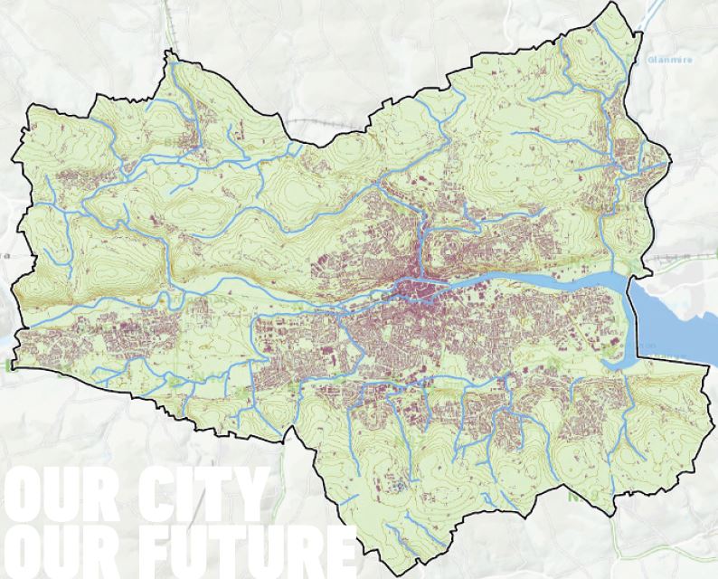
Figure 2.1: Cork City's Built Footprint in Context.
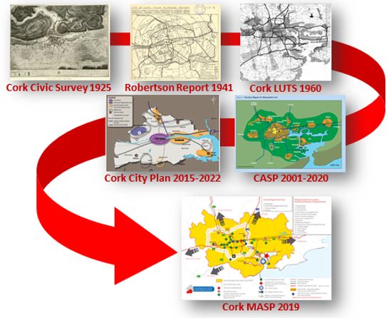
Figure 2.2: Land Use Planning in Cork Metropolitan Area.
Land Use Planning in Cork City
2.3
Land use planning in Cork City has a rich history, providing frameworks for growth that have helped shape the city we know today. Dating from the adoption of the Cork Civic Survey (1925), land use plans have set out objectives and actions guiding new developments within the city. This Plan seeks to build on many of these ambitions by providing a clear framework for future city growth that improves the quality of life for all its residents.
2.4
The Planning and Development (Amendment) Act 2010 introduced the requirement for Core Strategies as part of development plans. Section 10(2A) of the Act requires specific details to be included in core strategies, including how land use zonings accord with national and regional population targets and how these targets will be distributed across the city.
2.5
The core strategy sets out a growth plan for Cork City that includes population targets and locations for future growth up to 2028 and beyond. These targets and growth locations are in line with the overarching ambitions and targets set for Cork City in the NPF and the RSES.
2.6
A central function of the Core Strategy is ensuring an acceptable equilibrium in the supply of zoned, serviced land that allows for the projected population growth up to 2028. This requirement is informed by evidence. Cork City Council and Cork County Council jointly commissioned a Housing Strategy and Housing Needs Demands Analysis (HNDA). The study provides a forecast of the type and tenure of housing that will be required in the City and County for the period of the plan, thereby informing the quantum of zoned serviced land required to meet this target.
The United Nations Sustainable Development Goals
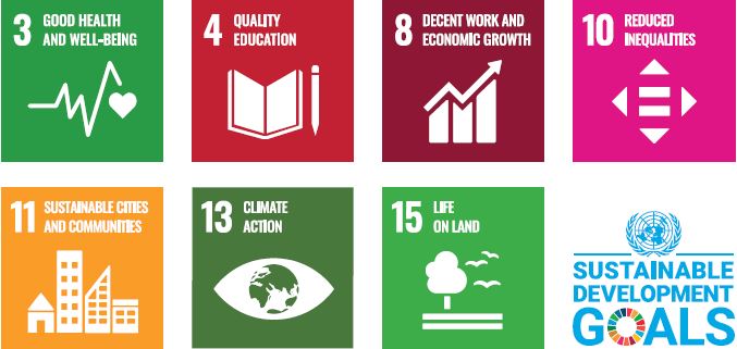
2.7
In September 2015 world leaders adopted the United Nations (UN) 2030 Agenda for Sustainable Development. The Agenda is a global road map setting out actions for people, the planet and prosperity. It is articulated through 17 Sustainable Development Goals (SDGs) set out to end poverty, fight inequality and injustice and tackle climate change by 2030. Each SDG has specific goals, targets and indicators that UN member states are using to frame their agendas and policies. This Plan is designed to ensure Cork City can play its role in supporting the delivery of the SDGs.

Figure 2.3: Irelands Spatial Planning Process in Context

Project Ireland 2040
2.8
Project Ireland 2040 is the Irish Government’s strategy to make Ireland a better country for all its people. It is designed to deliver on many of the UN SDGs by aligning public infrastructural investment with more sustainable spatial growth patterns. The National Development Plan (NDP) and the National Planning Framework (NPF) combine to form Project Ireland 2040. The NPF sets out the spatial strategy for growth and development and is underpinned by the public investment plan set out in the NDP.
2.9
The NPF is a statutory blueprint that plans for a projected 1 million increase in our national population, 550,000 more homes and an additional 660,000 jobs by 2040. The delivery of compact growth is central to the NPF, designed to enable people to live closer to where they work, maximise return on public investment and direct a shift away from current unsustainable spatial growth patterns. The NPF and the accompanying NPF Roadmap provide the statutory framework for the Regional Spatial and Economic Strategies (RSES) and all City and County Development Plans.
2.10
The NDP (2018-2027) provides investment policy to give certainty to future national growth. It includes investment priorities for Cork City and the wider region that underpin the implementation of the NPF, enabling a stable environment for infrastructure led growth. The delivery of infrastructure led development is critical to realising the NPF’s targets and the objectives for compact liveable growth set out in this Plan.
2.11
This Development Plan recognises the important overarching roles the UN SDGs, the NPF and the NDP play in shaping land use planning and management in Cork City. The Plans 9 strategic objectives connect directly to 17 UN SDG’s and the 10 National Strategic Outcomes (NSO’s) in the NPF.
Figure 2.4: Strategic Objectives for Cork City 2022-2028.
Regional Spatial and Economic Strategy for the Southern Region (RSES) and Cork Metrpolitan Area Strategic Plan (MASP)
2.12
The Regional Spatial and Economic Strategy for the Southern Region (RSES) is a regional framework supporting Project Ireland 2040 programme for change. As a regional plan it ensures coordination between the NPF, the NDP and the Cork City Development Plan. The central themes of the RSES are place making, climate action and sustainable economic growth.
2.13
The RSES is based on a regional settlement hierarchy. The strategy contains the Cork Metropolitan Area Strategic Plan (MASP) which provides a guide for investment and sustainable development across the Cork Metropolitan Area up to 2031. The MASP reinforces Cork City’s role as an international centre of scale to complement Dublin, targeting 50-60% population growth by 2040. This growth strategy uniquely positions Cork Metropolitan Area as:
• A principal complementary location to Dublin with a strong international role;
• A primary driver of economic and population growth in the region;
• A Metropolitan Area strengthening the vibrancy of its City Centre;
• A compact metropolitan area with increased regional connectivity; and
• A City Region focusing growth on the delivery of sustainable transport patterns.
2.14
The RSES supports investment and planning in Cork City and Metropolitan Area, including:
• Best practice regeneration of City and Tivoli Docks to deliver compact metropolitan growth;
• Investment in initiatives that delivery housing growth, increasing affordable housing and tenure mix, tackling vacancy and enhancing communites;
• Strengthen social and community development driven through the Local Economic Community Plan (LECP), Local Community Development Committee (LCDC) and RAPID initiatives;
• Investment in Cork as a Learning City including additional delivery of strategic educational and innovation infrastructure as enabling assets within the city;
• Capital investment in the TEN-T network and continued investment in the Port of Cork’s Strategic Development Plan including the relocation of the Port to Ringaskiddy;
• Delivery of a network of large city parks and smaller green areas throughout the metropolitan area and inner-city areas; and
• The continued development of Cork Airport as an international airport and the provision of high-
2.15
These and other aims are set out in a large number of Regional Policy Objectives (RPOs) which this Development Plan will aim to achieve.
2.16
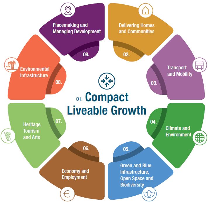
This Plan sets out nine Strategic Objectives (SO’s) to guide the future development of Cork City. The Core Strategy focuses on the SO of Compact Liveable Growth. The remaining SO’s each have an individual chapter setting out specific development objectives and actions. Given their nature, all nine SO’s are not solely the responsibility of Cork City Council to implement. The shape of the City’s future development will be a result of the joint efforts of Cork City Council, residents, stakeholders, developers, Government Departments and State and local development agencies, along with a range of other stakeholders in the city. The Plan’s 9 SO’s are summarised below, with the full text of each individual SO included in their relevant chapter within the Plan.

|
SO 1: Compact Liveable Growth Deliver compact growth that achieves a sustainable 15-minute city of scale providing integrated communities and walkable neighbourhoods, dockland and brownfield regeneration, infill development and strategic greenfield expansion adjacent to existing city. |

|
SO 2: Delivering Homes and Communities Provide densities that create liveable, integrated communities by using a mix of house types, tenures and sizes linked to active and public transport. Provide amenities, services and community and cultural uses to enable inclusive, diverse and culturally rich neighbourhoods. |
|
|
SO 3: Transport and Mobility Integrate land-use and transportation planning to increase active travel (walking and cycling) and public transport usage. Enable the key transport projects in the Cork Metropolitan Area Transport Strategy (CMATS) delivering multi-modal usage and smart mobility, accessible for all. |

|
SO 4: Climate and Environment Transition to a low-carbon, climate-resilient and environmentally sustainable future. Implement climate mitigation and adaptation measures that reduce our carbon footprint including sustainable energy consumption, sustainable transport, circular economy, green construction and flood risk mitigate and adaptation. |

|
SO 5: Green & Blue Infrastructure, Open Space and Biodiversity Manage and enhance green and blue infrastructure, to protect and promote biodiversity, ecology and habitat connectivity, protect natural areas, enhance landscape character and maritime heritage, and manage access to green and blue spaces that provide recreation, amenity and natural areas. |

|
SO 6: Economy and Employment Be a national and regional economic driver delivering strong, resilient, diverse and innovative economic growth. Focus new employment in strategic areas across the city. Enhance Cork’s role as a city of learning, using knowledge and talent as a key enabler for city and economic growth. |

|
SO 7: Heritage, Tourism and Arts Protect and enhance the unique character and built fabric of the city its neighbourhoods, urban towns and settlements by caring for Protected Structures, archaeological monuments and heritage, Architectural Conservation Areas and intangible heritage. Identify, protect, enhance and grow Corks unique cultural heritage and expression in an authentic and meaningful way. Ensure Cork’s heritage, culture and arts are celebrated and developed to create an attractive, vibrant and inclusive place to live, work, study and visit. |

|
SO 8: Environmental Infrastructure Ensure efficient and sustainable use of water services, enhance water quality and resource management. Manage waste generation and treatment and support the principles of the circular economy. Improve air quality and promote pro-active management of noise. Enable the sustainable delivery of digital infrastructure, renewable energy and environmental improvements. |

|
SO 9: Placemaking and Managing Development Develop a compact liveable city based on attractive, diverse and accessible urban spaces and places. Focus on enhancing walkable neighbourhoods that promote healthy living, wellbeing and active lifestyles, where placemaking is at the heart. Follow a design-led approach with innovative architecture, landscape and urban design that respects the character of the city and neighbourhood. |
Table 2.1: Strategic Objectives for Cork City 2022-2028
Cork City 2040
2.17
The ambitious growth targets set out for Cork City in Project Ireland 2040 require long term planning. This includes active land management, long term investment, climate action, infrastructure led development, integrated community development and enhanced heritage, culture and arts. Delivering these will require sustained co-ordination between many city, regional and state stakeholders.

2.18
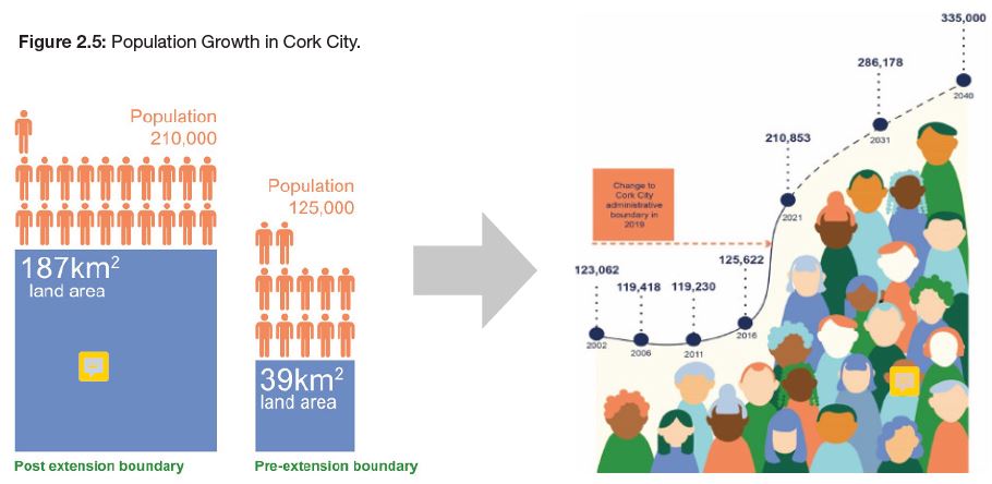
The extension of Cork City Councils administrative boundary in May 2019, expanded the city by five times its previous size, increasing its population to 210,853 persons. Cork is now defined as a medium sized European Port City, comparable to Malmo, Bilboa, Aarhus and Bremerhaven in terms of scale and function. The NPF recognises this status, setting out bold new growth targets reflecting the city’s critical role in enhancing Ireland’s metropolitan profile. To effectively fulfil this role, the NPF requires the city to have ambitious vision that maximises its potential as an internationally competitive and sustainable growth city in a best practice European context.
Figure 2.5: Population Growth in Cork City.
2.19
The NPF targets 60% population growth for Cork City by 2040. This will result in an additional 125,000 people living in the City within 20 years. A breakdown of shows how the City will need to achieve 10% - 17% population growth within each of the next four census periods. Over the last 30 years, Cork City has grown at a lower rate of 2% - 5%. Significant planning and investment will be required over a sustained period to achieve the NPF growth target by 2040.
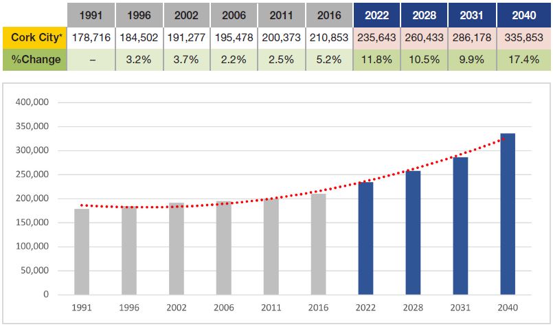
Figure 2.6: Population Trends and Targets, 1991-2040 ('Best estimates based on current boundary)

2.20
Cork City seeks to achieve ambitious 2040 growth targets in a way that delivers a high quality of life for all residents. This involves long term strategic planning and proactive land management to sustain investment and growth, tackle climate change, care for community and neighbourhood development and protect and enhance the City’s natural and built heritage. The Cork City 2040 Concept Plan sets out longer-term context for the delivery of land use planning and management. While not a statutory land use plan, it applies relevant RSES and NPF targets, policies and objectives up to 2040 to provide a framework for the delivery of the ambitions for Cork. It focuses on how Cork City can best drive the development of the Southern Region and in particular the Cork Metropolitan Area. The Concept Plan will be further articulated in future City Developments Plans.
2.21
Figure 2.8 illustrates how the concept plan is intended as a spatial framework to provide clearer pathways for longer term growth within an existing and emerging network of neighbourhoods and areas that make up Cork City. The regeneration of City Docks and Tivoli Docks along with other brownfield sites are important in delivering compact liveable growth in Cork City by 2040. Expansion of residential, employment, cultural and community uses in the City Centre and City Suburbs will increase vibrancy in existing neighbourhoods and decrease underutilised buildings and sites.
2.22
The delivery of Light Rail Transit (LRT) and its interaction with the Lee to Sea greenway, suburban rail network, orbital bus routes and strategic bus corridors will deliver transport orientated development in key areas such as Blackpool, Ballyvolane, Mahon and South Ballincollig and an integrated multimodal city transport system. Longer term strategic planning and delivery of growth in areas such as Tramore Road, Stoneview and the lands located between the City and Ballincollig will further enhance the delivery of growth in Cork City and align with the NPF’s strategic objectives and population growth targets out to 2040.
Figure 2.7: Cork City 2040
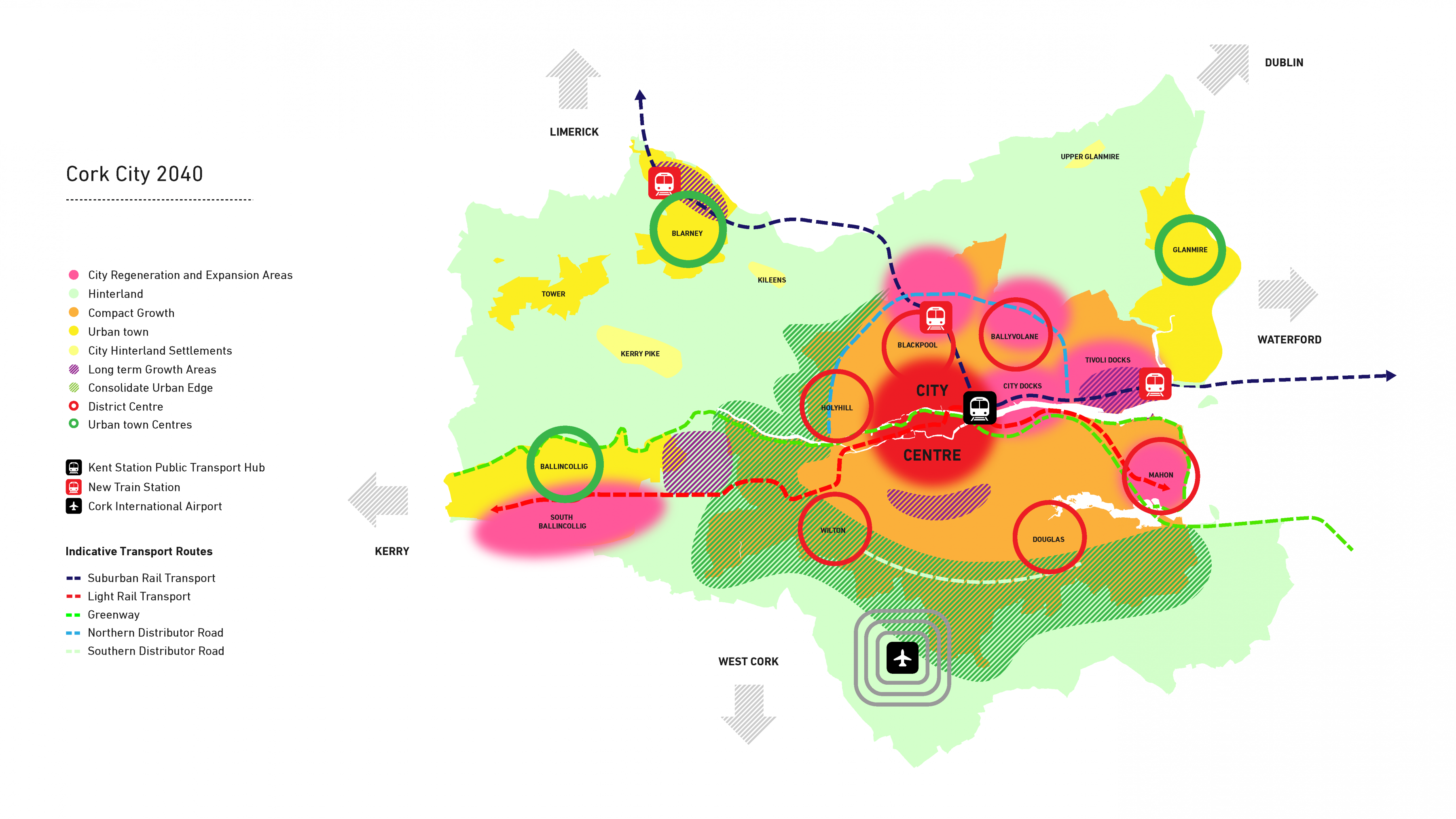
Figure 2.8: Cork City 2040 Concept Plan. (Click on Map for High Resolution Image)
Delivering Compact Liveable Growth
2.23
A number of key factors have influenced the Core Strategy set out in this plan. The ‘15-minute city’ and ‘walkable neighbourhoods’ are ’ two key approaches offering sustainable building blocks for land use planning, central to delivering compact liveable growth in the City. A series of supporting strategies and studies have also been carried out to provide an evidence base in areas such as housing, green and blue infrastructure, employment, retail, urban density and building height. In addition, a City Capacity Study was undertaken to fully assess capacity for future development within underutilised zoned lands.

2.24
This Plan is being prepared and delivered in a time of a global climate change emergency and a global pandemic. This context has reiterated the need for a more resilient city that maintains and improves the quality of the natural and built environment for the benefit of current and future generations. The 15-Minute City is an urban planning response to the UN SDGs and the Climate Change emergency. It provides a timely framework that combines proximity and social fabric to achieve positive change in our urban lifestyle and a new rhythm in our City. This new rhythm centres on increasing multipurpose functions, ease of access, peopleorientated design and a sense of place.
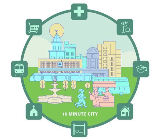
Figure 2.9: The 15 Minute City.
2.25
The basic concept of a 15-minute city is where residents have easy access to their essential needs at distances taking no more than 15 minutes by public transport, foot or by bicycle. It is based on a network of liveable neighbourhoods and communities that offer diverse housing options, with safe access to active and public transport, local health care, education, shops, and other community infrastructure. Every resident’s 15-minute city differs due to their mobility preferences, their location, the quality of services and differing abilities to access these services.
2.26
In a highly functional 15-minute city, all residents enjoy a high quality of life through the ease in which they live, work, provide, care, learn and enjoy life within their urban environment. It also supports social inclusion by providing jobs, housing and services within the people’s immediate neighbourhood. Integrating a diverse mix of uses into an urban environment is of central importance, counter-acting traditional land use planning approaches of separating land uses from each other. Applying the 15-minute city to objectives within this City Development Plan and during its implementation will help achieve positive changes in urban lifestyles and a new city rhythm.

2.27
The 15-minute city is based on a network of neighbourhoods at a scale that puts people first. While the 15-minute city includes travel by public transport, walkable neighbourhoods concentrate on local active travel – walking and cycling. The design of new buildings and public spaces respect local context and offer constant opportunities to interact. New development focuses on creating a positive experience for people and communities in their neighbourhood, including a mix of uses that increase interactions at street level. Well designed neighbourhoods provide a quality of life for the individual and their neighbourhood that stimulates and enriches everyday lives.
2.28
Cork City has an existing and emerging network of neighbourhoods within the city centre, the city suburbs and the four urban towns. This network is based on 10-minute walking areas (800m) that provide a mix of homes, schools, shops, parks, jobs and community spaces. Planning for Liveable Walkable Neighbourhoods requires the integration of a range of house types and tenures, jobs, recreation, green space, local shops, medical centres, small businesses and more. New developments need to reflect and respond to existing context by delivering the right mix of uses at a scale and design that creates high quality places. They also need to enhance the neighbourhood by increasing social interactions that improve the quality of life.
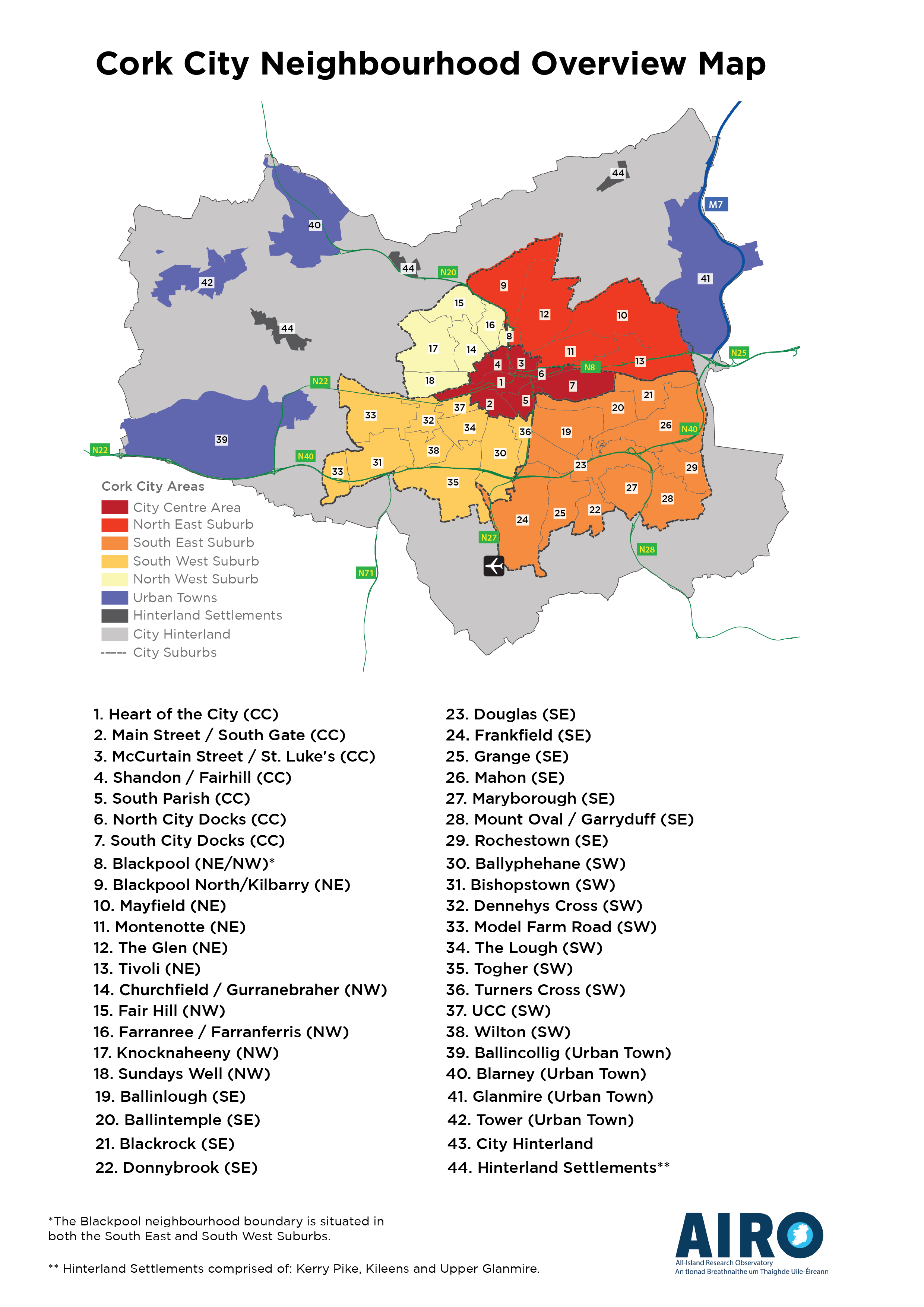
|
1. Heart of the City (CC) 2. Main Street / South Gate (CC 3. McCurtain Street / St. Luke’s (CC) 4. Shandon / Fairhill (CC) 5. South Parish (CC) 6. North City Docks (CC) 7. South City Docks (CC) 8. Blackpool (NE/NW)* 9. Blackpool North/Kilbarry (NE) 10. Mayfield (NE) 11. Montenotte (NE) 12. The Glen (NE) 13. Tivoli (NE) 14. Churchfield / Gurranebraher (NW) 15. Fair Hill (NW) |
16. Farranree/Farranferris (NW) 17. Knocknaheeny (NW) 18. Sundays Well (NW) 19. Ballinlough (SE) 20. Ballintemple (SE) 21. Blackrock (SE) 22. Donnybrook (SE) 23. Douglas (SE) 24. Frankfield (SE) 25. Grange (SE) 26. Mahon (SE) 27. Marybourough (SE) 28. Mount Oval/Garryduff (SE) 29. Rochestown (SE) 30. Ballyphehane (SW) |
31. Bishopstown (SW) 32. Dennehys Cross (SW) 33. Model Farm Road (SW) 34. The Lough (SW) 35. Togher (SW) 36. Turners Cross (SW) 37. UCC (SW) 38. Wilton (SW) 39. Ballincollig (Urban Town) 40. Blarney (Urban Town) 41. Glanmire (Urban Town) 42. Tower (Urban Town) 43. City Hinterland 44. Hinterland Settlements** |
Figure 2:10: Liveable Walkable Neighbourhoods, Communities and Urban Towns. (Click on Map for High Resolution Image)
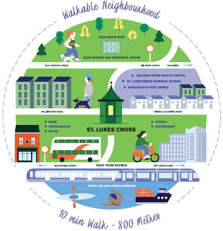
Figure 2:11: A Liveable Walkable Neighbourhoods.
2.29
Understanding the nature and context of an existing neighbourhood, town or community is the starting point for good planning and design. The Cork City Neighbourhood Profile (2021) sets out a socioeconomic profile of the network of neighbourhoods, towns and communities in the city. Based on census data, it uses a series of indicators to provide individual profiles. It also provides comparative data to gain a better understanding of similarities and differences between neighbourhoods. The profile has been designed as an evidence base to allow developers, planners and the wider community to make informed decisions about the nature, mix and form of new development at neighbourhood level. The profile will be updated following the completion of the next census, providing further evidence for monitoring and review at neighbourhood level.

2.30
In preparing this Plan, Cork City Council carried out a series of supporting strategies and studies that provide an evidence based approach to planning and, where possible, to reflect on best international practice. The studies cover a range of land use planning areas such as housing, green and blue infrastructure, employment, retail, urban density and building height and are prepared to inform the delivery and implementation of this Plan.
Cork City and County Joint Housing
Strategy and Housing Need Demand
Assessment 2022-2028:
This strategy, which was jointly commissioned by Cork City Council and Cork County Council, provides an evidence base to inform development plan targets for housing and population, and to understand the likely mix of households looking to find a home in Cork City and County. The HNDA and Housing Strategy provide the necessary analysis and policy recommendations to ensure that housing demand supply will be met.
Cork Metropolitan Area Joint Retail
Strategy 2022-2028:
This strategy, which was commissioned jointly by Cork City Council and Cork County Council, sets out a plan-led approach to retail development and the retail hierarchy, floorspace allocations and objectives for the sequential approach to retail planning across the Cork Metropolitan Area. Specific objectives guiding retail typologies, placemaking, vacancy and regeneration are also set out in the strategy.
Cork City Neighbourhood Profile:
This study sets out a socio-economic profile of the network of neighbourhoods, towns, and communities in the city. It uses a series of indicators based on census data to provide individual profiles for neighbourhoods and towns. It also provides comparative data to evaluate these places. The profile provides the evidence to inform developers, planners and the wider community to make evidence based decisions on the nature, mix and form of new development at neighbourhood level.
Cork City Active Recreational
Needs Study:
This study determines the quantum of active recreational needs facilities required, the role of these facilities and the benefits of investing in sport including policy guidance to safeguard the provision of land for recreation and open space. As part of this study an audit and review of the existing recreational infrastructure in the City was carried out, including consultation with key stakeholders.
Cork City Strategic Employment
Locations Study:
This study focuses on strategic employment and is informed by a baseline assessment of existing zoned employment land in the city, and by scenario modelling, market analysis and international best practice. The study recommends a jobs growth target and associated zoned employment land target to support the population and jobs growth ambitions for the City in accordance with the NPF and MASP.
Cork City Urban Density, Building
Height and Tall Building Study:
The study provides a coherent analysis of Cork City and its potential to accommodate dense forms of development based on the suitability and sensitivity of areas to change due to their particular characters. The study focuses on increasing densities in locations benefitting from access to good levels of public transport, services and designation as opportunity areas. This also reiterates the importance that Cork City Council will place on innovation in design and that increased densities are design led and functional for the people and communities that will use them.
Cork Green and Blue Infrastructure
(GBI) Study:
GBI is the term used to describe the network of natural and semi-natural green and blue spaces and corridors in a given area such as parks and gardens, woodlands, fields, hedges, lakes, ponds, playing fields, coastal habitats, cycle routes, rivers /water courses. Compact liveable growth includes the need to reduce the human impact on the environment and transition to a low carbon city. This study reviewed GBI assets in Cork City to consider how to protect, enhance and link this network of spaces. Locations where new high quality GBI is needed to support existing communities are identified.
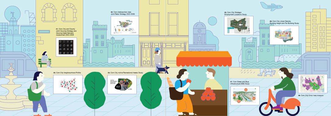
Figure 2.12: An Evidence-Based Approach to Cork City's Development Plan
Cork City Child Yield Analysis:
This study was prepared to plan for the needs of children in development proposals, this study analyses census data, international best practice and uses trend-based modelling to indicate the likely number of children expected from any given development. The study presents estimates for childcare, education and open space needs arising from an individual scheme or multiple schemes using forecast modelling.

2.31
A City Capacity Study was carried out to assess the capacity of Cork City for future development within existing underutilised zoned lands, which includes a combination of greenfield, brownfield and infill sites. The study was undertaken in the context of National Policy Objective 72(a) set out in the NPF. NPO 72(a) requires Planning Authorities to apply a stadardised, tiered approach to differentiate between; (i) zoned land that is serviced and (ii) zoned land that is serviceable within the life of the Plan. This study has informed the required level of land use zoning for residential use in Cork City to meet targets set out in the NPF for the plan period 2022 – 2028.
2.32
Much of the underutilised land identified is serviced or serviceable in the short and medium term, including many infill and brownfield sites within the existing built-up area. Other lands require new infrastructure or have additional constraints such as contamination, remediation, access issues or servicing. Investment in infrastructure will be critical in realising the development of these lands.
2.33
Some brownfield sites with existing active uses, such as state or institutional, were excluded. Their delivery timeframe cannot be estimated as they may or may not change use over time. These will be treated as windfall sites, if or when they become available. Such sites will require careful planning and design, including detailed framework plans that ensure best practice regeneration based on the character and nature of their existing urban environments.
IMAGE BUS

2.34
The Joint Cork Housing Strategy includes an assessment of housing market trends in Cork since 1970. Fig 2.13 shows how Cork has consistently accounted for 10% - 15% of national new-build homes. Following the economic crash in 2010, new home construction declined dramatically. While gradually recovering, it remains well below the long-term average. The housing strategy highlights how the Cork housing market is currently marked by a supply/demand mismatch, with under-supply remaining a serious issue, particularly in key urban areas.
2.35
Figure 2.14 shows how, reflecting the national trend, the City’s more recent dwelling completion rates is characterised by considerable change. In the period between 2011 - 2016 dwelling completion rates were minimal. From 2016 completion rates have generally grown steadily, all be it from a very low base.

Figure 2.13: An analysis of Housing Completions in Cork since 1970, source: Joint Housing Strategy.
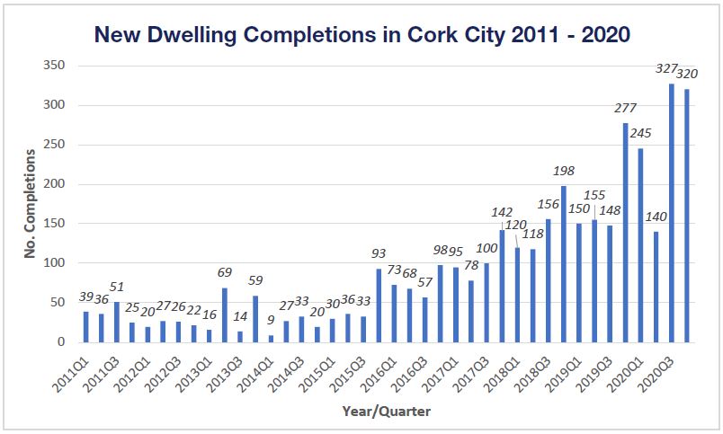
Figure 2.14: Quarterly Dwelling Completions for current Cork City area 2011-2020 (Source: CSO 2021).
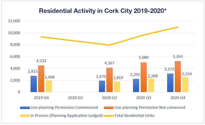
Figure 2.15: Residential Development Activity, Source: CSO 2021 ('excludes social and student units).
2.36
Figure 2.15 is an analysis of recent residential development and planning activity in Cork City. In Q4, 2020 commencement was underway on sites with planning permission to deliver over 3,173 new residential units. In addition, the city has capacity to deliver more than 5,200 additional residential units via live planning permissions not yet commenced. A further 2,554 residential units are currently being assessed through the planning application stage.
2.37
While this increase in planning activity is a progressive step, it illustrates how the implementation of planning permissions and the delivery of residential units remains largely dependent on the market. As Fig 2.16 shows, further measures are needed to ensure the housing market in Cork City can deliver the housing stock required to meet the ambitious NPF population growth targets set out in this Plan.
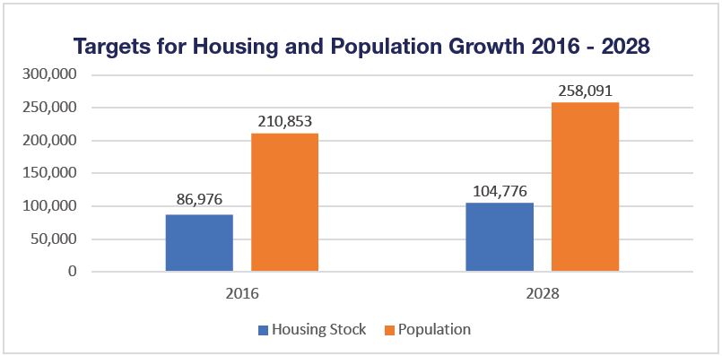
Figure 2.16: Targeted Housing Stock and Population Growth, Source: CSO 2021
2.38
The introduction of the vacant site levy under the Urban Regeneration and Housing Act 2015 (as amended) is an enabling tool for local authorities to stimulate development. Cork City Council will continue to progress the delivery of development on these sites through active land management measures. Under the Derelict Sites Act 1990 (as amended), Cork City Council also has powers to add sites and buildings to the Derelict Sites Register. Cork City Council will continue to implement these powers to reduce dereliction in the city.

2.39
Residential development is a central driver in realising and sustaining population growth. There are other additional factors that need consideration when planning for population change. Changes to average household size, migration and immigration rates and changes to tenure mix and student housing numbers all contribute to population change in the city. Quality of life also plays a defining role in influencing population change. Delivering a wide range of improvements in the urban environment, community infrastructure and cultural experiences improves the quality of life on offer in a city. This higher quality of life leads to an increase in the numbers of people seeking to live, work, study, visit and experience the city.
2.40
Trends over the last 20 years show an increasingly urbanised global and national population. Cork City has begun to experience this trend more recently, with the population living in the city centre growing by 19% during the last census period (2011-2016). This growth was four times the rate experienced within the wider city (+5%) and occurred during a period of very low new residential development. Changes in household size have a significant impact on population growth. Ireland recorded an average household size of 2.75 in Census 2016. Cork City recorded a smaller AHS of 2.63 with notable differences at neighbourhood level, ranging from 1.74 in St. Luke’s to 3.25 in Frankfield. Figure 2.17 illustrates the range and variety in AHS across the city.
2.41
The Joint Cork Housing Strategy and Housing Need Demand Assessment (HNDA) 2022-2028 has carried out detailed assessment to help predict and plan for changes in future AHS during the plan period and beyond.
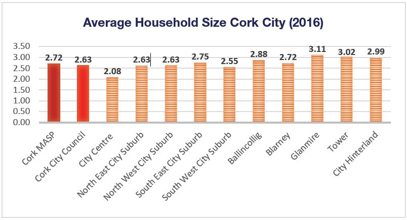
Figure 2.17: Average Household Size (AHS), Source: Census 2016
Figure 2.18: Average Household Sizes (AHS), Source: Census 2016
Cork City 2028: Compact Liveable Growth
2.43
Compact Liveable Growth promotes growth at the right locations primarily through regeneration, consolidation and re-intensification. This growth is supported by new physical and social infrastructure that puts people first, supporting everyday life that makes it easy and safe to move around Cork City. A mix of uses and densities provide high quality design and ensure a balance between protecting the amenities and character of a neighbourhood.
2.44
New development is designed to create people friendly environments for new homes, communities, employment, culture and learning. Buildings, public space and public places are designed for people, making room for life to unfold within the city at different times of day and night. Vibrancy is achieved through increasing social proximity that delivers a mix of uses, densities, house types and tenures, age groups, cultures and experiences within a rich urban environment. This mix creates a diverse, resilient and adaptable city more responsive to the changing world in which we live.

2.45
Cork City’s Core Strategy Map (Figure 2.20) and Table (Table 2.2) set out a land use strategy for Compact Liveable Growth for the plan period and beyond. The NPF population targets, detailed in section 2.9, are distributed to enhance and grow the existing network of neighbourhoods, towns and settlements in the city. The strategy provides the rationale for land use zonings and site-specific objectives set out in this Plan. It is based on a detailed analysis of the housing delivery potential carried out in the Joint Cork Housing Strategy and HNDA. It has also been prepared and informed by an appraisal of infrastructural capacities of sites and areas to accommodate new development within and adjoining the existing built-up area of the city.
2.46
The Core Strategy Map spatially illustrates strategic expansion areas within the city and the Core Strategy Table sets out accompanying population targets. The strategy also focuses on the delivery of core bus corridors, the Lee-to-Sea greenway and the longer-term delivery of an LRT alongside enhancing walking and cycling networks. The strategy is based on the following objectives for city growth, detailed further in Table 2.5.
1. City Centre:
Increased regeneration and consolidation of Cork City Centre focusing on the delivery of more homes and providing a broader mix of uses to enhance the city centres role as an employment, retail, cultural, learning and entertainment destination.
2. Docklands:
The City Docks regeneration project is of international importance, offering 146ha of brownfield lands adjacent to the city centre with potential to be an exemplar for sustainable urban living. Tivoli Docks is a unique opportunity for longer-term brownfield regeneration of 56ha of waterfront located 2.5km from the city centre and on the rail line.
3. City Consolidation and Expansion:
The delivery of compact growth includes the consolidation and expansion of seven strategic areas within and adjoining the existing City:
• Blackpool (Kilbarry),
• Ballyvolane (East)
• Ballyvolane (West)
• South Ballincollig (Maglin)
• South Glanmire (Ballinglanna)
• Douglas (Castletreasure)
• East Blarney.
4. District Centres and Urban Town Centres:
Six district centres are identified to enhance the role these areas already play as centres providing a mix of uses for their surrounding neighbourhoods. Three urban town centres are identified to further deliver an appropriate mix of uses to meet local need.
5. Neighbourhood Development Sites:
The strategy identifies underutilised sites within existing neighbourhoods and towns that are locally important. These sites have significant capacity for neighbourhood regeneration to enhance the delivery of walkable neighbourhoods and the 15-minute city (see ch.10 for more detail).
6. The Hinterland:
Growth in the city hinterland is managed through the delivery of scaled community, housing and local employment developments in the settlements of Killeens, Upper Glanmire and Kerry Pike. Any development proposals in the remainder of the hinterland will be closely managed to protect against unnecessary and unplanned urban sprawl.
Figure 2.19: Cork City 2028.
2.47
The Core Strategy Table (Table 2.2) distributes the NPF population targets within the city. These targets are set against the current population of an area (Census 2016) showing proportionate levels of growth being planned for at a local level. The table sets out a range of different targets including major growth for City Docklands, the strategic expansion of areas such as Ballincollig, Glanmire and Blarney and the consolidation of the City Centre, the City Suburbs and Tower.
2.48
The Core Strategy provides certainty on the location of all lands zoned needed to achieve NPF growth targets within the city up to 2028. By breaking these targets down to site specific locations, the strategy directly links to the zoning objectives set out in Chapter 12 Land Use Zoning Objectives. This approach allows all stakeholders to concentrate on more detailed planning required to deliver housing, service and transport infrastructure, neighbourhood amenities, urban design and place making at a local level. It also allows Cork City Council to carry out other active land management measures necessary to help realise the ambitious growth targets set out for the City.
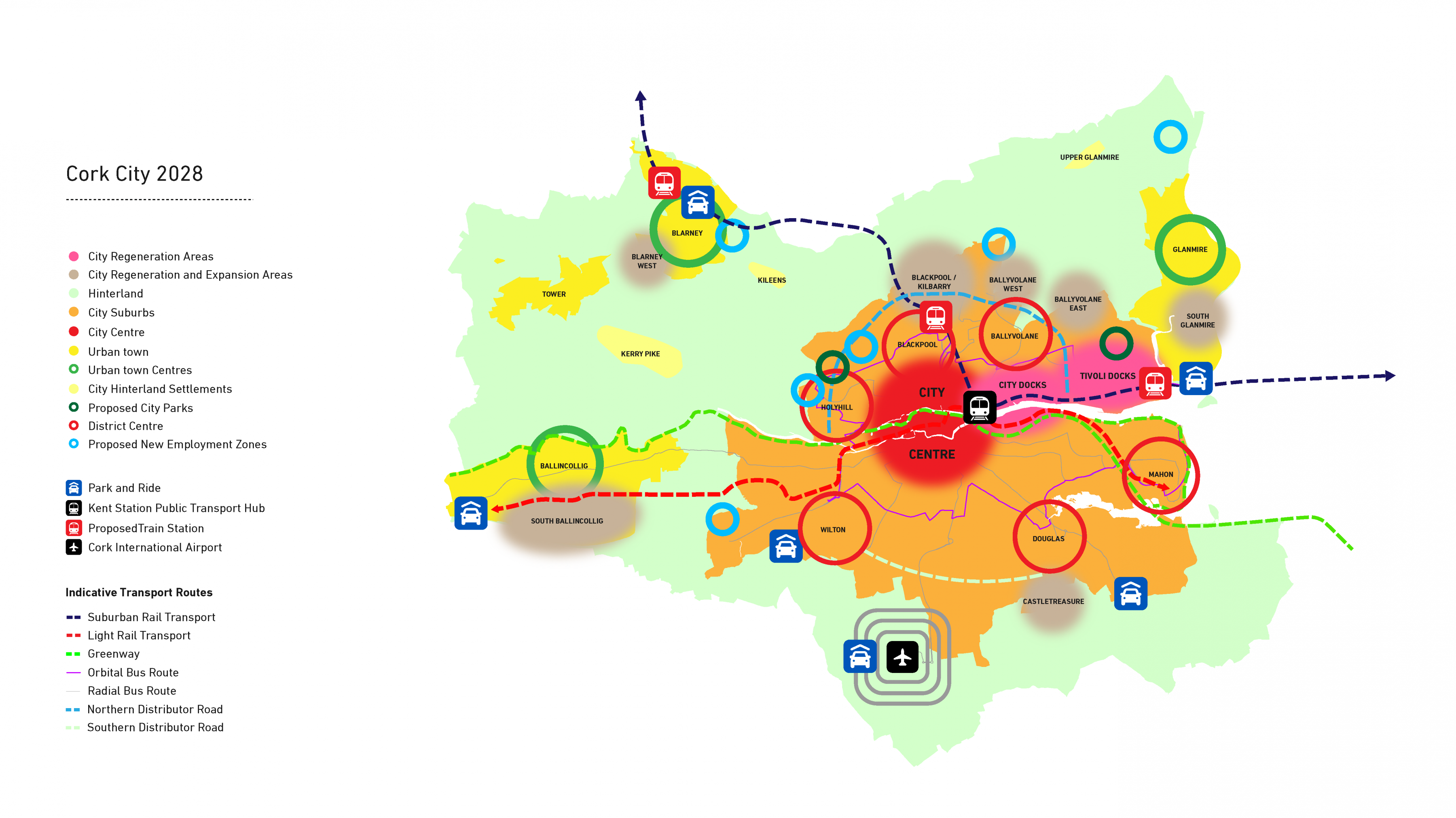
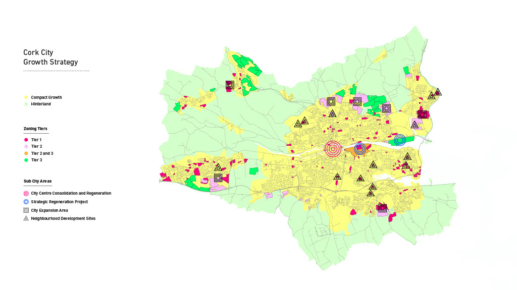
Figure 2.20: Core Strategy Map 2022-2028. (Click on Map for High Resolution Image)
Core Strategy 2028: Compact Liveable Growth1 |
||||||
|---|---|---|---|---|---|---|

|
Baseline Population (2016) |
Future Population Growth (2028) |
Actual Population Growth (2028) |
|||
|
Exiisting Population |
% of Total Population |
Future Population | % of Total Growth | Actual Population Growth | Proportionate Growth Rate | |
| City Centre | 22,732 | 10.8% | 26,218 | 7.0% | 3,486 | 15% |
| City Centre Regeneration (New Build) | - | - | 23,945 | 2.4% | 1,213 | 5% |
| City Centre Consolidation (re-use) | - | - | 2,273 | 4.6% | 2,273 | 10% |
| Docklands | 1,667 | 0.8% | 7,737 | 12.2% | 6,070 | 364% |
| City Docks | 1,667 | 0.8% | 7,239 | 11.2% | 5,572 | 334% |
| Tivoli Docks | 0 | 0.0% | 498 | 1.0% | 498 | - |
| City Suburbs | 141,808 | 66.7% | 160,289 | 37.3% | 18,481 | 13% |
| North East Suburb | 26,841 | 12.7% | 35,561 | 17.6% | 8,720 | 32% |
| North West Suburb | 23,125 | 11.0% | 23,728 | 1.2% | 603 | 3% |
| South East Suburb | 51,605 | 24.5% | 58,457 | 13.8% | 6,852 | 13% |
| South West Suburb | 40,237 | 19.1% | 42,543 | 4.7% | 2,306 | 6% |
| Urban Town | 33,886 | 16.1% | 54,650 | 41.9% | 20,764 | 61% |
| Ballincollig | 18,159 | 8.6% | 29,003 | 21.9% | 10,844 | 60% |
| Blarney | 2,550 | 1.2% | 5,881 | 6.7% | 3,331 | 131% |
| Glanmire | 9,903 | 4.7% | 15,329 | 10.9% | 5,426 | 55% |
| Tower | 3,274 | 1.6% | 4,437 | 2.3% | 1,163 | 36% |
| Hinterland | 10,521 | 5.0% | 11,300 | 1.6% | 779 | 7% |
| Hinterland Settlements (3) | 1,792 | 0.8% | 1,971 | 0.4% | 179 | 10% |
| City Hinterland (Single Dwellings) | 8,729 | 4.1% | 9,329 | 1.2% | 600 | 7% |
| NET Total (-25% site area) | 210,8532 | 100% | 260,194 | 100% | 49,580 | 24% |
Table 2.2: Core Strategy Table 2022-2028.
2.49
The Growth Strategy Map and Table set out in Figure 2.21 and Table 2.3, provide site level detail of the growth allocations set out in the Core Strategy. The map and table are in line with the estimated future housing need set in the Joint Cork Housing Strategy and the Housing Needs Demand Assessment (HNDA).
2.50
In accordance with National Policy Objective 72(a) of the NPF, the map and table differentiate between Tier 1 and Tier 2 sites. Tier 1 sites are zoned lands that are currently serviced by physical infrastructure. Tier 2 sites are zoned land that are considered serviceable by physical infrastructure within the life of this Plan. While the NPF’s tiered approach does not focus on community infrastructure, this is of central importance in the creation of sustainable neighbourhoods and is covered in detail in Chapter 3 Delivering Homes and Communities.
2.51
This Plan also identifies Tier 3 lands zoned but considered as being unlikely to be serviced during the lifetime of this Plan. These lands are identified as long term strategic sites needing long term planning and service delivery. They are identified to ensure active land management by safeguarding and strategically planning for the longer term growth needed to achieve ambitious NPF growth targets. For these reasons Tier 3 lands are not included within the Core Strategy for calculation purposes. Table 2.4 details the location and quantum of Tier 3 lands within the city.
2.52
The potential unit yields set out in the Growth Strategy Table below are based on the following:
• An Average Household Size (AHS) of 2.49, in line with the Housing Strategy;
• For sites with valid planning permission, the number of granted units is applied;
• For sites with no valid planning permission, densities set out in the Cork City Urban Density and Building Height Study are applied;
• Where there is no valid planning permission, a gross to net deduction of 25% of the site area has been applied to allow for the provision of roads, open space, community facilities, etc;
• Given the windfall nature of sites without valid planning permission in the City Centre and Suburbs, a 50% yield is applied to capture more realistic delivery levels up to 2028;
• Given existing infrastructural constraints in the city, an 80% yield is applied to Tier 2 sites without valid planning permission to capture more realistic delivery up to 2028; and
• For City Docks and Tivoli Docks, specific unit targets are applied based on population target objectives set out in chapter 10 of this plan.
2.53
The unit output from all current extant planning permissions are accounted for within the Growth Strategy Table (Table 2.3). These generally have lower residential densities than allowable under this plan. The Growth Strategy Table therefore has a lower potential population yield than set out in the Core Strategy Table (Table 2.2), when the AHS of 2.49 is applied. This difference is based on the expected increased densities on sites with extant planning permissions. This will be achieved by way of future planning permissions granted in accordance with the objectives set out in this plan.
2.54
The Growth Strategy Map also indicates planning categories for different areas within Cork City, to reflect their role in delivering the core strategy. These categories are discussed in more detail in Table 2.5 below, and Chapter 10 of this plan:
1. City Centre Consolidation and Regeneration: Regeneration and consolidation of Cork City Centre focusing on the delivery of a broader mix of uses to enhance vibrancy and activity.
2. Strategic Regeneration: Regeneration of Cork Docklands as project of international importance with potential to be exemplars for sustainable urban living.
3. City Expansion Areas: The consolidation and expansion of seven strategic areas as new neighbourhoods, within and adjoining the existing city.
4. Neighbourhood Development Sites: Locally important underultised sites with capacity for mix used regeneration that deliver walkable neighbourhoods.
Figure 2.21: Growth Strategy Map 2022-2028 (Click on Map for High Resolution Image)
Growth Strategy 2028 (Tier 1 & 2)3 |
||||
|---|---|---|---|---|
| Location |
Underutilised Sites (NetHectare's) |
Potential Tier 1 & 2 Yield (Units) | Tier 1 Potential Yield Units | Tier 2 Potential Yield Units |
| City Centre | 2.0 | 487 | 487 | 0 |
| Docklands | 16.8 | 2,438 | 988 | 1,450 |
| City Docks | 14.4 | 2,238 | 988 | 1,250 |
| Tivoli Docks | 2.4 | 200 | 0 | 200 |
| City Suburbs | 304 | 7,477 | 3,627 | 3,850 |
| North East Suburbs | 169.1 | 3,568 | 603 | 2,965 |
| North West Suburbs | 10.7 | 242 | 242 | 0 |
| South East Central Urban Area | 92.7 | 2,741 | 2,417 | 324 |
| South West Central Urban Area | 32.4 | 926 | 365 | 561 |
| Urban Town | 315.5 | 8,339 | 4,075 | 4,264 |
| Ballincollig | 157.4 | 4,355 | 2,156 | 2,199 |
| Blarney | 47.3 | 1,338 | 641 | 697 |
| Glanmire | 89.7 | 2,179 | 1,089 | 1,090 |
| Tower | 21.1 | 467 | 189 | 278 |
| Total | 632.2 | 18,741 | 9,177 | 9,564 |
Table 2.3: Cork City Growth Strategy Table 2022 - 2028
Cork City - Tier 3 Lands4 |
||
| Location | Underutilised Sites (NetHectare's) | Potential Tier 1 & 2 Yield (Units) |
| City Centre | 0.0 | 0 |
| Docklands | 86.9 | 12,527 |
| City Docks | 36.6 | 7,775 |
| Tivoli Docks | 50.3 | 4,752 |
| City Suburbs | 152.8 | 3,008 |
| North East Suburb | 132.7 | 2,479 |
| North West Suburb | 0.0 | 0 |
| South East Central Urban Area | 0.0 | 0 |
| South West Central Urban Area | 20.1 | 529 |
| Urban Town | 161.8 | 5,463 |
| Ballincollig | 26.1 | 850 |
| Blarney | 116.5 | 4,071 |
| Glanmire | 13.9 | 332 |
| Tower | 5.3 | 210 |
| Total | 401.5 | 20,998 |
Table 2.4: Table of Tier 3 Lands.


2.55
National Planning Objective 3(b) of the NPF requires at least half (50%) of all new homes targeted in each of Irelands 5 cities to be delivered within their existing built-up footprint. Appendix 4 of the NPF sets out a definition of “existing built-up footprint” based on a CSO definition. When applied to Cork City this definition is too broad, as it covers the majority of lands within the City boundary. To address this, an assessment of the location and nature of all sites in the Core Strategy has been carried out. This determined whether these sites are within the existing built-up footprint or are greenfield in nature. Sites largely surrounded by existing development are considered to be within the city’s existing built-up footprint. This includes infill and brownfield sites and sites contiguous to the existing city or urban town. Lands that are largely separate from the existing built-up footprint are considered greenfield in nature. Table 2.5 and Figure 2.20 show how 67% of the Tier 1 and Tier 2 lands set out in the core strategy are located within the existing built-up footprint of the City. This reflects the Core Strategy’s objectives and targets to deliver compact growth in line with the NPF.
Existing Built-Up Footprint & Greenfield Targets 2022-2028 Tier 1 and Tier 2 Lands |
|||
|---|---|---|---|
| Type of Land | Net Hectares | Potential Residential Output | % of Total Housing Output |
| Existing Footprint | 356.7 | 12,123 | 64.7% |
| Tier 1 | 223.1 | 7,896 | 42.1% |
| Tier 2 | 133.6 | 4,227 | 22.6% |
| Greenfield | 275.5 | 6,618 | 35.3% |
| Tier 1 | 34.7 | 1,269 | 6.8% |
| Tier 2 | 240.8 | 5,349 | 28.5% |
| Total | 632.2 | 18,741 | 100% |
Table 2.5: Built-Up Footprint and Greenfield Growth Targets 2022-2028
Figure 2.22: Built-Up Footprint and Greenfield Growth Target Locations 2022-2028. (Click on Map for High Resolution Image)

2.56
Following on from the Core Strategy Maps and Tables presented above, the Table below identifies the roles, key sites and key deliverables the Core Strategy will play in shaping land use planning in Cork City during this Plan period:
| City Area | Role in the Core Strategy | Some Key Sites | Key Deliverables |
| City Centre |
Consolidate and regenerate the city centre to underpin its role as the vibrant, living and working heart of the city and metro area. Provide a wider range of employment, cultural, learning and community uses that increase vibrancy and activity. Encourage more homes in mixed use areas by increasing residential and employment uses, especially on upper floors. Encourage a broader mix of cultural and tourism uses, including educational entertainment. Develop at a scale and form that reflects and respects the city centres historic character. |
Grand Parade Quarter
Infill and consolidation |
1. Grand Parade Quarter: A Transformational Project. 2. Cork City Centre Revitalisation Action Plan 2021-2025. 3. Guidance and actions to increase upper floor uses. 4. Progress the Vacant and Derelicts sites registers and supports. |
| Docklands | Phased regeneration of the City Docks and Tivoli Docks as high quality, higher density, mixed use sustainable waterfront areas with new urban quarters and transformational projects acting as catalyst for further investment and regeneration of the City. |
City Docks: Marina Park,
Tivoli Docks: New train |
1. City Docklands: A Transformational Project. 2. Establish the Cork Docklands Office. 3. Deliver catalyst infrastructure. 4. Progress planning and infrastructure to deliver regeneration in Tivoli Docks. |
| City Suburbs |
Consolidate and enhance by providing a mix of new neighbourhood uses in suitable underutilised locations. Prioritise walking, cycling and public transport access. Deliver uses, layouts and densities that enhance existing local character. Deliver high quality sustainable transport orientated development in combination with high frequency bus routes, the new commuter station at Blackpool (Kilbarry) and prioritised cycling and walking routes set out in CMATS. |
Ballyvolane, Mahon Blackpool / Kilbarry, North-West Quarter Regeneration area, Old Whitechurch Road. Regenerate underutilised sites in existing neighbourhoods including Mayfield, Douglas, Grange, Togher and Wilton. |
1. Delivery of CMATS 2. Framework plans for Blackpool / Kilbarry, Ballyvolane, and Douglas. 3. Action plans for Neighbourhood Development Sites. 4. New City Parks in the Northeast and Northwest suburbs. |
| Urban Towns | Phased delivery of strategic sites by targeting growth proportionate to the existing population within the four urban towns. All development shall focus on prioritising walking, cycling and public transport use. Apply a mixed-use approach to regenerating key underutilised locations. Use a range of designs and densities that reflect and enhance the individual character of each town. |
Expansion of South
Opportunities to |
1. Framework plans for South Ballincollig and South Glanmire. 2. Heritage led plans for Blarney and Tower. 3. Action plans for key sites (Neighbourhood Development Sites). 4. Plan for the long-term delivery. |
|
Hinterland Settlements |
Allow for the sustainable growth of Killeens, Glanmire Upper and Kerry Pike through infill, brownfield or edge of centre development within defined settlement boundaries. |
Growth of 15% within the three hinterland settlements. |
1. Consolidated village centres. 2. Apply Sustainable Growth targets. |
| City Hinterland | Additional development needs to be examined in the context of the local and environmental characteristics of the area. Balance any future development with the wider needs of Cork City to achieve compact growth and more sustainable transport patterns. Ensure environmental preservation and the retention and enhancement of urban and rural character. Cork Airport will be supported in its role as an international gateway for the City, wider Metropolitan Area and Southern Region from a transport, connectivity and economic viewpoint. |
Cork Airport, GBI networks, local community |
1. Sustainable development of Cork Airport 2. Sustainable development of green and blue infrastructure networks |
Table:2.5: Summary of Key Objectives for City Growth.
City Hinterland Strategy
2.57
The City Hinterland encircles the existing built-up footprint of Cork City, its urban towns and settlements. Its size, character and nature provide a number of very important planning functions:
• Acts as a greenbelt preventing urban sprawl into the surrounding countryside;
• Is rich in biodiversity, ecology and wildlife;
• Provides a valuable range of green and blue infrastructure assets;
• Ensures a distinctive landscape character and setting within the Cork Metropolitan Area; and
• Protects the character and integrity of the city and its urban towns and settlements.
2.58
Figure 2.23 and Figure 2.24 show how the incremental development of single houses in the City Hinterland has increasingly led to urban sprawl that is changing the landscape and character of this area.
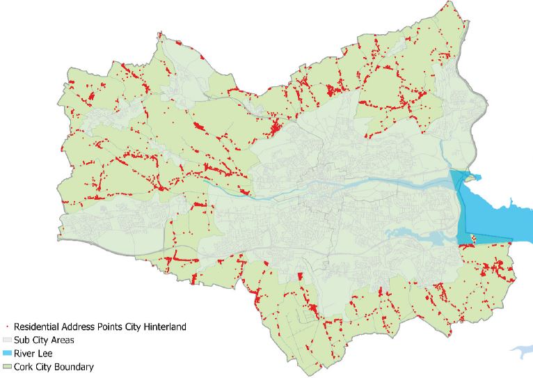
Figure 2.23: Residential address points in Cork City's Hinterland 2021 (Source: Geo-Directory).
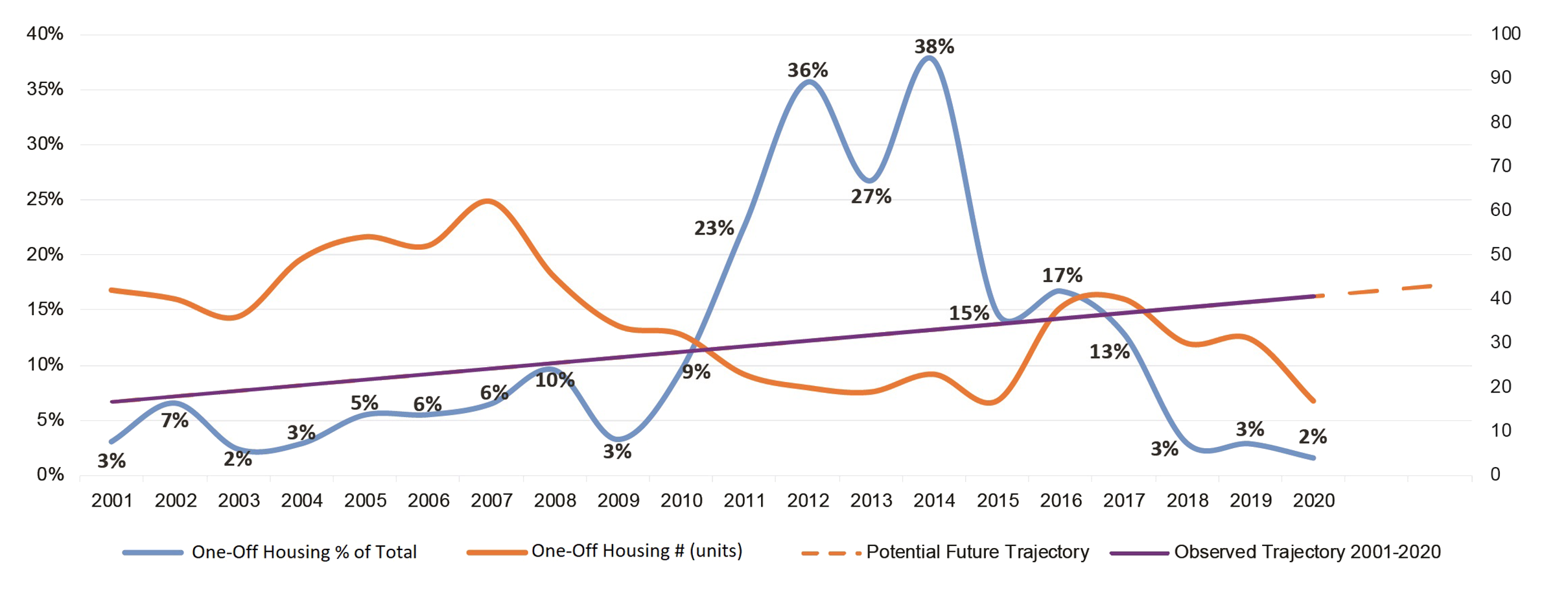
Figure 2.24: One-Off Housing in Cork City 2001-2020 (Source: Draft Joint Cork Housing Strategy).
2.59
The primary objective for City Hinterland is to preserve the character of the area generally for use as agriculture, rural amenity, open space, recreational uses, green and blue infrastructure and to protect and enhance biodiversity. Chapter 10 sets out detailed objectives to achieve these aims.
Delivering the Core Strategy
2.60
Delivery of the Core Strategy will be supported through active land management, focusing on measurable performance in accordance with the objectives set out in this section. Cork City Council will identify priorities and incentives, including relevant finance and funding options, to help deliver compact liveable growth. Cork City Council will collaborate with key stakeholders to support the achievement of Core Strategy objectives. Furthermore, Cork City Council will monitor the delivery of the Plan to support the realisation of these objectives.

2.61
A key aim of Cork City Council is to unlock the development capacity of strategic growth areas identified in the Core Strategy. These sites will require enhanced co-ordination between stakeholders and service providers with a strong focus on delivering enabling infrastructure. To support this aim, the Council will promote an active land management approach that accelerates the development of strategic growth areas.

2.62
In partnership with Government departments, state agencies and service providers, Cork City Council will play an active role in enabling the growth and development set out in this Plan. The Council will seek to maximise delivery of strategic funding initiatives like the Urban Regeneration and Development Fund (URDF), the Local Infrastructure Housing Activation Fund (LIHAF) and the Serviced Sites Fund (SSF) that support local authorities in providing key enabling infrastructure. Cork City Council will also seek to highlight the importance in actively addressing any critical infrastructure blockages, to accelerate delivery of housing and regeneration on key development sites by helping to minimise delays in the delivery of utilities such as water, transport, energy services and other key infrastructure delivered by national service providers.

2.63
The resourcing and delivery of financing structures will be critical to unlocking the regeneration of strategic sites within Cork City. Given the complex nature of developing urban sites including the mix of land ownerships involved, alternative sources of financing and innovative funding mechanisms will be required. The need to increase the supply of affordable housing and affordable cost-rental further increases the challenges in designing appropriate financing mechanisms.
2.64
Having regard to these challenges, Cork City Council will seek to enable suitable partnerships that harness financial expertise that exists across a range of publicly supported institutions such as; the Land Development Agency (LDA), National Treasury Management Agency (NTMA), National Asset Management Agency (NAMA), Housing Finance Agency (HFA), Ireland Strategic Investment Fund (ISIF) and Home Building Finance Ireland (HBFI), among others. The delivery of sustainable and best practice urban regeneration, including increased levels of affordable housing, shall be a central consideration in the design of these financial mechanisms.
IMAGE RIVER CATHEDRAL

2.65
Cork City Council will monitor the delivery of the actions and objectives set out in this Plan to better understand to what extent the Plan is being realised. This approach to monitoring moves toward to a richer form of planning review by incorporating measurable indicators for bette evaluation, and will assist Cork City Council in meeting statutory reporting requirements including the two year progress report (as required under Section 15(2) of The Act) and the report to the Southern Regional Assembly setting out progress made in support of the RSES (as required under Section 25A(1) of The Act).
2.66
While planning policy objectives often take a number of plan cycles to be fully realised, the monitoring of the delivery and implementation of this Plan will provide a first step towards assessing the plans outcomes, continuing through successive City Development Plans.
2.67
Cork City Council will also seek to adapt and update the Cork City Capacity Study database for use as an urban brownfield and infill land register for the purposes of monitoring the NPF compact growth targets. This database will draw from other relevant spatial datasets used nationally to support active land management, development oversight and monitoring.
2.68
In conjunction with the Southern Regional Assembly, Cork City Council will review how the City Development Plan is progressing by monitoring the environmental effects of the plans implementation as set out in the SEA Environmental Report and Statement.
|
To increase the population of Cork City in line with national and regional growth targets.
To support the delivery of the Core Strategy by: Applying a tiered approach to land use |

|
Objective 2.1 |
|
Objective 2.2 |
|
United Nations
|
National Planning
|
|||
|
|
Objective 2.3 |
|
Objective 2.4 |
|
National Development
|
Cork Metropolitan Area
|
|||
|
|
Objective 2.5 |
|
Objective 2.6 |
|
Regional InvestmentTo identify and seek investment packages into the Cork Metropolitan Area from European and Government Exchequer funding streams that help deliver population and job targets, prioritise infrastructure led investment and quality of place. |
Strategic ObjectivesPrioritise the development of areas in accordance with the 9 Strategic Objectives (SO’s) of the Core Strategy, as set out in Table 2.1, including areas which are experiencing and/or are likely to experience large scale development or regeneration within the plan period. |
|||
|
|
Objective 2.7 |
|
Objective 2.8 |
|
Long Term PlanningTo support a longer-term strategic planning approach to help safeguard strategically important lands necessary to deliver future compact growth in Cork City in line with the NPF 2040. |
The 15-Minute CityTo support the delivery of a 15-Minute City delivering Compact Liveable Growth through walkable neighbourhoods, towns and communities with a mix of uses, house types and tenures that foster a diverse, resilient, socially inclusive and responsive city. Strategic infrastructure and large-scale developments shall demonstrate how they contribute to a 15 minute city and enhance Cork City’s liveability. |
|||
|
|
Objective 2.9 |
|
Objective 2.10 |
|
Low Carbon CitySupport the delivery of a lower carbon, sustainable city where development avoids, mitigates and adapts to the effects of climate change while protecting and enhancing Cork City’s environmental assets. |
Mix of UsesSupport the delivery of a diverse mix of suitable uses that enhance Cork City’s network of neighbourhoods, towns and communities as places to live, work, provide, care, learn and enjoy. |
|||
|
|
Objective 2.11 |
|
Objective 2.12 |
|
Design-Led CityFollow a design-led approach that delivers sustainable, high quality placemaking. Development shall contribute positively to the quality of the surrounding built and natural environment and shall be planned and designed with reference to climate change mitigation and adaptation. |
Walkable Neighbourhoods
New development shall be designed to make positive additions to their neighbourhoods, towns and communities by: |
|||
|
|
Objective 2.13 |
|
Objective 2.14 |
|
Cork City Neighbourhood
|
Neighbourhood MixPromote high quality neighbourhoods by increasing the range of community, recreational, local enterprise, cultural and leisure related facilities. |
|||
|
|
Objective 2.15 |
|
Objective 2.16 |
|
Neighbourhood DesignThe design and siting of development shall create a sense of community and identity, enhance connectivity, incorporate creative approaches to urban design, enhance landscape character and green and blue infrastructure and respect the local context and character of the area. |
Supporting Strategies
|
|||
|
|
Objective 2.17 |
|
Objective 2.18 |
|
Strategic RegenerationSupport and enable the development and renewal of strategic regeneration sites in Cork Docklands, Cork City Centre and areas throughout the city as key deliverables to achieve NPF growth targets. |
Underutilised SitesCork City Council will actively seek to address issues of dereliction, vacancy and underutilisation of sites within Cork City by encouraging and facilitating their re use and regeneration subject to good planning and the infrastructural carrying capacities of the area. |
|||
|
|
Objective 2.19 |
|
Objective 2.20 |
|
Windfall SitesStrategic brownfield sites with existing active uses will be treated as windfall sites. The redevelopment of these sites, if or when they become available, will require careful consideration. For such sites, Cork City Council will require agreement on a detailed framework plan at an early stage to ensure best practice regeneration and design based on the character and nature of their existing urban environments. |
Vacant Site LevyActively encourage by way of the vacant site levy, the development of vacant sites for housing and regeneration purposes through active implementation of the provisions of the Urban Regeneration and Housing Act 2015 (as amended). |
|||
|
|
Objective 2.21 |
|
Objective 2.22 |
|
Derelicts Site RegisterProgress, by way of the Derelict Sites Register, the development of derelict sites for housing and regeneration purposes through consultation with landowners and the application of powers under the Derelict Sites Act 1990 (as amended) and other means available to Cork City Council. |
Population GrowthIn planning for future population growth, Cork City Council will assess important factors such as changing average household size, tenure, type and mix (including student accommodation) and existing occupancy and vacancy rates within an area. These factors will help inform policy making, development management guidance and decisions for new development proposals in the city. |
|||
|
|
Objective 2.23 |
|
Objective 2.24 |
|
Quality of LifeIn planning for future population growth, Cork City Council will assess and monitor quality of life factors including improvements in the urban environment, community infrastructure and cultural experiences that can increase the numbers of people seeking to live, work, study, visit and experience the city. |
Implementing the
|
|||
|
|
Objective 2.25 |
|
Objective 2.26 |
|
Compact GrowthIt is an objective to target the delivery of 65% of all new homes in Cork City on lands within the existing built footprint of the city, as set out in the Core Strategy. |
Housing SupplySupport an increase in the supply, affordability and quality of new housing in city and provide a range of housing options delivering good design that is appropriate to the character of the area in which it is built. |
|||
|
|
Objective 2.27 |
|
Objective 2.28 |
|
Long Term PlanningSafeguard and plan for the longer term delivery of the lands reserved as Tier 3, marked accordingly on Figure 2.21 and Table 2.4. Protect these lands for strategic long term growth. |
Supply of Zoned LandMonitor and review the Core Strategy to ensure that sufficient zoned land continues to be available to meet the City’s housing requirements over the lifetime of the Plan. |
|||
|
|
Objective 2.29 |
|
Objective 2.30 |
|
Development in
|
Managing the HinterlandAny development proposals in the remainder of the hinterland will be closely managed to protect against unnecessary and unplanned urban sprawl. |
|||
|
|
Objective 2.31 |
|
Objective 2.32 |
|
Enhanced Co-ordinationTo promote an active land management approach through enhanced co-ordination with relevant stakeholders and infrastructure providers in the delivery of enabling infrastructure in order to accelerate the development of strategic growth areas. |
Funding Strategic SitesTo maximise delivery of strategic funding initiatives that support local authorities in providing key enabling infrastructure. To actively address any critical infrastructure blockages and delays, wherever possible, to accelerate delivery of housing and regeneration on key development sites. |
|||
|
|
Objective 2.33 |
|
Objective 2.34 |
|
Supporting Enabling
|
Monitoring and
|
|||
|
|
Objective 2.35 |
|
Objective 2.36 |
|
Monitoring RegenerationTo support active land management and development by continuously monitoring the level of development in brownfield, infill and greenfield sites, with an aim to support the targets and objectives of the Cork City Development Plan, the Cork MASP and the NPF. |
SEA Monitoring
Cork City Council shall, in conjunction with the Southern Regional Assembly and other stakeholders as relevant, implement the monitoring programme as set out in the SEA Environmental Report and Statement. This will include the preparation of stand alone SEA Monitoring Reports: |
|||
Photo Location: Father Matthew Memorial Fountain, Fitzgerald's Park
- 1- Includes sites identified in the Cork City Capacity Study measuring 0.25ha in size or greater.
-
2- Includes a margin of error (0.1% or 239 persons) due to the difference between CSO 2016 city figure
and sub city breakdown estimate figures calculated by AIRO
- 3- Refer to section 2.11.2 listing assumptions applied to estimate potential unit yields.
- 4- Refer to section 2.11.2 listing assumptions applied to estimate potential unit yields.
Clár ábhair
Tagairtí
Tuairimí
Tuairimí
Comments on the entire development plan
Please see attached document.
Support for the Save Cork City Plan
Please see letter attached (Please note address and phone no. has been redacted).